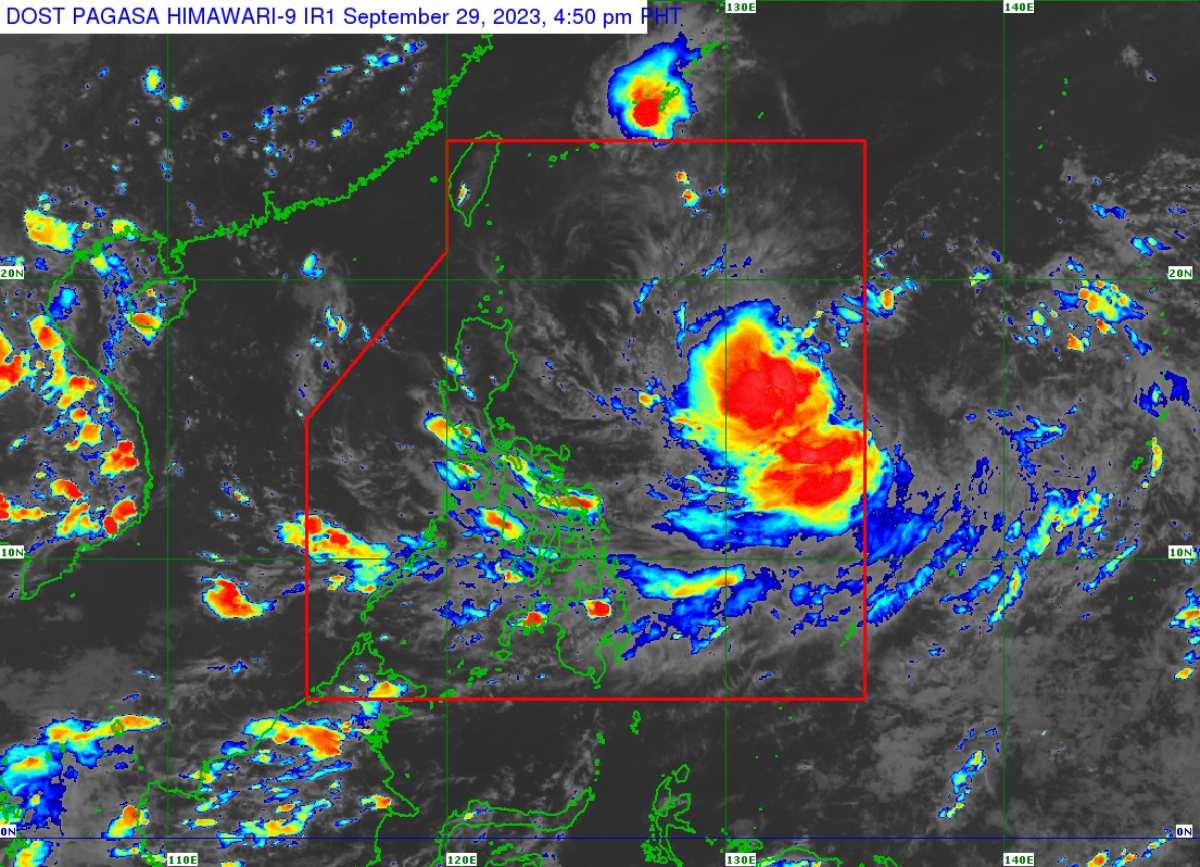
MANILA, Philippines – The low pressure area (LPA) east of Central Luzon has entered the Philippine Area of Responsibility (PAR) and developed into tropical depression 'Jenny', state weather bureau PAGASA announced in its 5:00 pm bulletin on Friday, September 29, 2023.
At 4:00 am today, the center of the eye of 'Bagyong Jenny' was estimated based on all available data at 1,400 km East of Southeastern Luzon.
'Jenny' has maximum sustained winds of 45 km/h near the center, gustiness of up to 55 km/h, and central pressure of 1004 hPa. It is moving westward at 20 km/h. Strong winds extend outwards up to 240 km from the center.
TRACK AND INTENSITY OUTLOOK
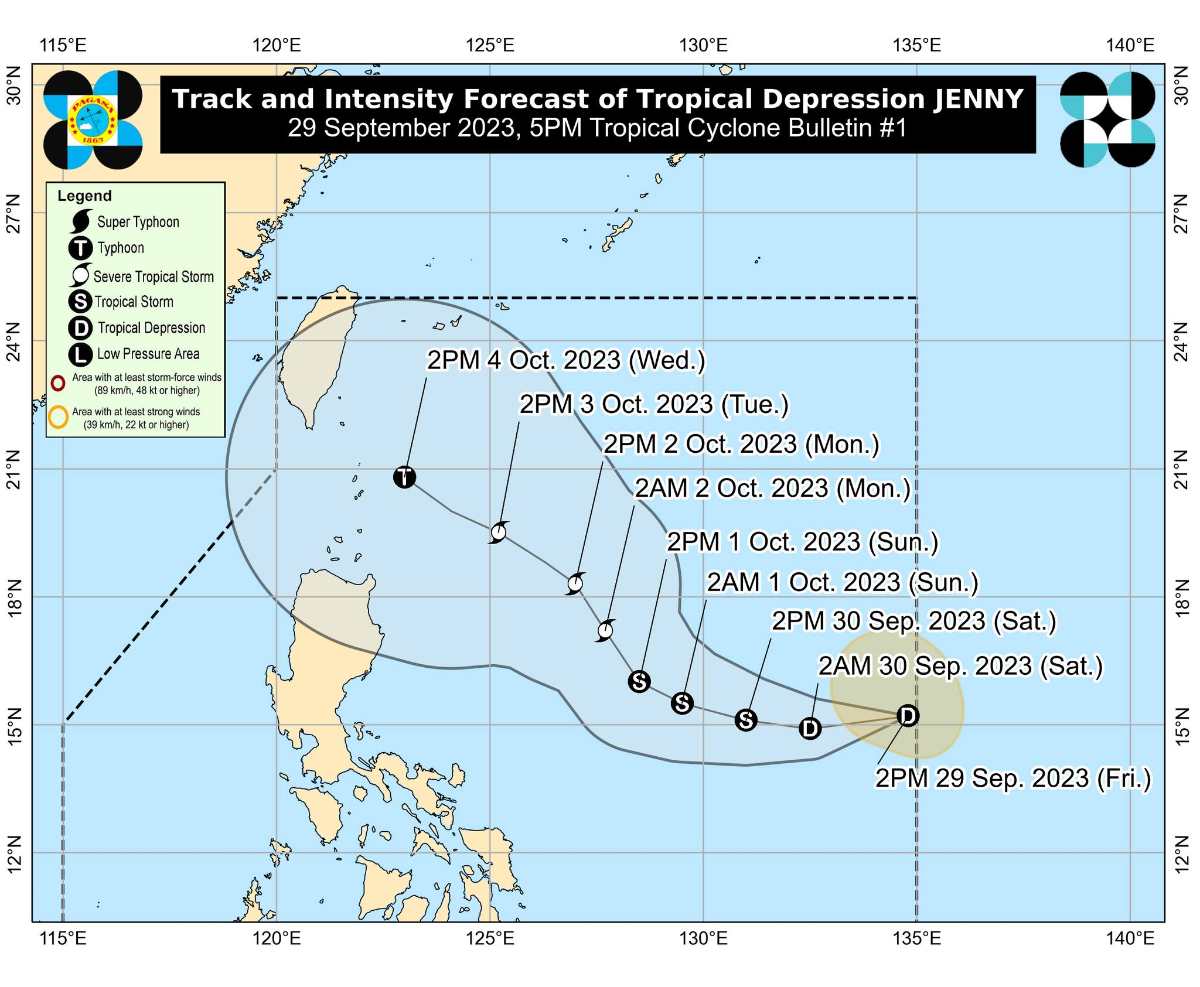
'Jenny' is forecast to track generally westward or west northwestward until Saturday before turning further north over the Philippine Sea east of Northern and Central Luzon.
On the forecast track, a close approach over the Batanes area by Wednesday. A landfall scenario over Batanes-Babuyan or northeastern mainland Cagayan is not ruled out since this is within the forecast confidence cone.
The tropical cyclone is forecast to steadily intensify throughout the forecast period and may reach tropical storm category tomorrow afternoon. It may be upgraded into a typhoon category by Wednesday during its close approach over Batanes area.
TROPICAL CYCLONE WIND SIGNALS (TCWS) IN EFFECT
No Wind Signal hoisted at this time.
HAZARDS AFFECTING LAND AREAS
Heavy Rainfall Outlook
Tropical Depression 'Jenny' is not directly affecting the country. However, considering the proximity of the tropical cyclone to land from the forecast track, this may result heavy rainfall over Batanes and Babuyan Islands in the next five days.
The Southwest Monsoon may be enhanced by this tropical cyclone beginning on Sunday, resulting in possible occasional rains over the western portions of Central and Southern Luzon. As such, the possibility of issuing a Weather Advisory for Southwest Monsoon is not ruled out.
Severe Winds
The current forecast scenario shows that hoisting of Tropical Cyclone Wind Signals over areas in Northern Luzon may begin on Sunday in anticipation of the onset of tropical cyclone severe winds. However, the hoisting may happen earlier should there be changes in the forecast scenario.
The possible enhancement of Southwest Monsoon may result in gusty conditions beginning on Sunday over most of Southern Luzon and Visayas. The gusty conditions are more likely in coastal and upland/mountainous areas exposed to winds.
HAZARDS AFFECTING COASTAL WATERS
On Monday, 'Jenny' may bring moderate to rough seas (1.5 to 2.5 m) over the coastal waters of Extreme Northern Luzon and the northeastern portion of mainland Cagayan.
Mariners of motor bancas and similarly-sized vessels are advised to avoid navigating in these conditions, especially if inexperienced or operating ill-equipped vessels.
TROPICAL CYCLONES
'Bagyong Jenny' is the 10th tropical cyclone to enter PAR this year.
On average, there are 20 tropical cyclones that could form or enter the PAR each year. Only half of those are projected to make landfall.
SEE ALSO: LIST: Typhoon, tropical cyclone names in the Philippines 2023
— The Summit Express
 |
| Satellite image of 'Bagyong Jenny' as of 4:50 pm, September 29, 2023. Photo courtesy of DOST-PAGASA |
At 4:00 am today, the center of the eye of 'Bagyong Jenny' was estimated based on all available data at 1,400 km East of Southeastern Luzon.
'Jenny' has maximum sustained winds of 45 km/h near the center, gustiness of up to 55 km/h, and central pressure of 1004 hPa. It is moving westward at 20 km/h. Strong winds extend outwards up to 240 km from the center.
TRACK AND INTENSITY OUTLOOK
'Jenny' is forecast to track generally westward or west northwestward until Saturday before turning further north over the Philippine Sea east of Northern and Central Luzon.
On the forecast track, a close approach over the Batanes area by Wednesday. A landfall scenario over Batanes-Babuyan or northeastern mainland Cagayan is not ruled out since this is within the forecast confidence cone.
The tropical cyclone is forecast to steadily intensify throughout the forecast period and may reach tropical storm category tomorrow afternoon. It may be upgraded into a typhoon category by Wednesday during its close approach over Batanes area.
TROPICAL CYCLONE WIND SIGNALS (TCWS) IN EFFECT
No Wind Signal hoisted at this time.
HAZARDS AFFECTING LAND AREAS
Heavy Rainfall Outlook
Tropical Depression 'Jenny' is not directly affecting the country. However, considering the proximity of the tropical cyclone to land from the forecast track, this may result heavy rainfall over Batanes and Babuyan Islands in the next five days.
The Southwest Monsoon may be enhanced by this tropical cyclone beginning on Sunday, resulting in possible occasional rains over the western portions of Central and Southern Luzon. As such, the possibility of issuing a Weather Advisory for Southwest Monsoon is not ruled out.
Severe Winds
The current forecast scenario shows that hoisting of Tropical Cyclone Wind Signals over areas in Northern Luzon may begin on Sunday in anticipation of the onset of tropical cyclone severe winds. However, the hoisting may happen earlier should there be changes in the forecast scenario.
The possible enhancement of Southwest Monsoon may result in gusty conditions beginning on Sunday over most of Southern Luzon and Visayas. The gusty conditions are more likely in coastal and upland/mountainous areas exposed to winds.
HAZARDS AFFECTING COASTAL WATERS
On Monday, 'Jenny' may bring moderate to rough seas (1.5 to 2.5 m) over the coastal waters of Extreme Northern Luzon and the northeastern portion of mainland Cagayan.
Mariners of motor bancas and similarly-sized vessels are advised to avoid navigating in these conditions, especially if inexperienced or operating ill-equipped vessels.
TROPICAL CYCLONES
'Bagyong Jenny' is the 10th tropical cyclone to enter PAR this year.
On average, there are 20 tropical cyclones that could form or enter the PAR each year. Only half of those are projected to make landfall.
SEE ALSO: LIST: Typhoon, tropical cyclone names in the Philippines 2023
— The Summit Express

