MANILA, Philippines – 'Bagyong Hanna' (international name: Haikui) maintains its strength over the Philippine Sea, state weather bureau PAGASA announced in its 5:00 am bulletin on Friday, September 1, 2023.
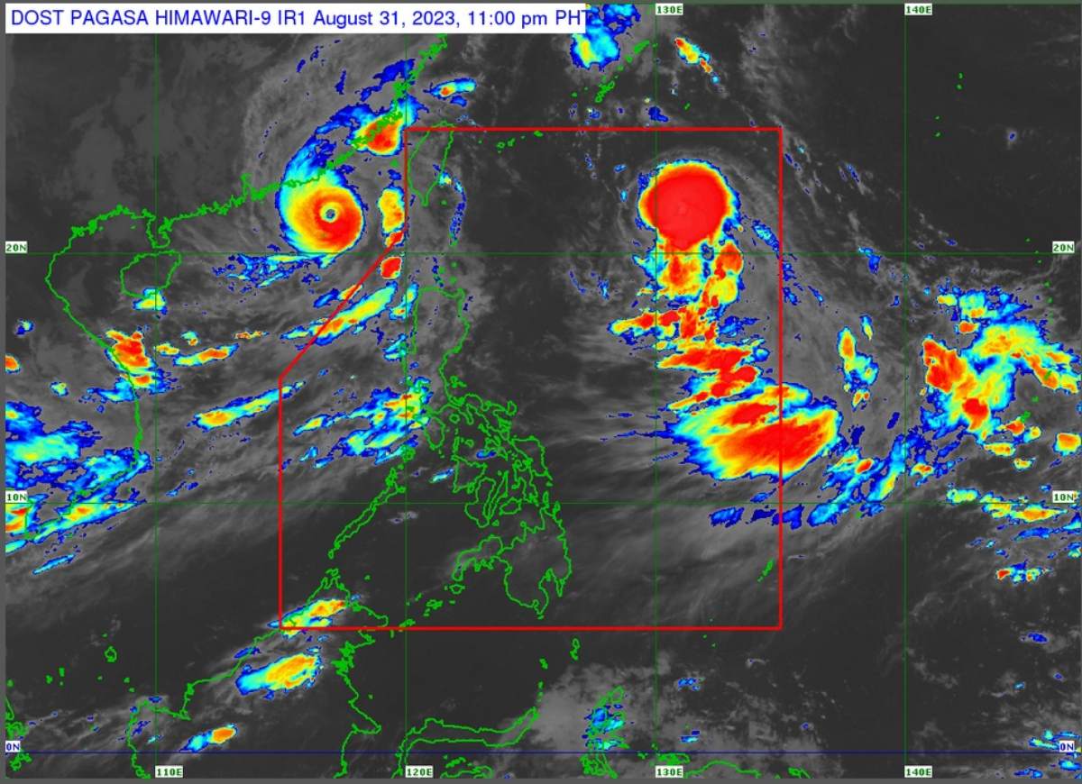
At 4:00 am today, the center of Severe Tropical Storm 'Hanna' was estimated based on all available data at 870 km East of Extreme Northern Luzon.
'Bagyong Hanna' has maximum sustained winds of 110 km/h near the center, gustiness of up to 135 km/h, and central pressure of 980 hPa. It is moving west northwestward at 20 km/h. Strong to storm-force winds extend outwards up to 340 km from the center.
TROPICAL CYCLONE WIND SIGNALS (TCWS) IN EFFECT
No Wind Signal hoisted at this time.
TRACK AND INTENSITY OUTLOOK
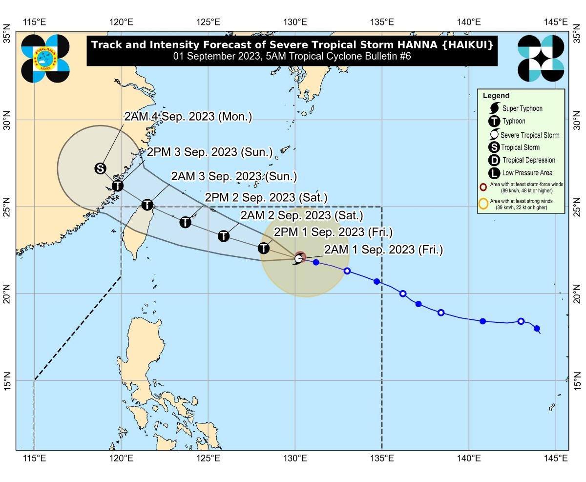
'Bagyong Hanna' is forecast to move generally west northwestward throughout the forecast period.
On the track forecast, the tropical cyclone is forecast to pass close or make landfall in the vicinity of Yaeyama Islands in the Ryukyu archipelago between tomorrow morning and afternoon, then make landfall or pass close to the northern portion of Taiwan tomorrow evening or on Sunday morning.
'Hanna' is forecast to exit the Philippine Area of Responsibility (PAR) on Sunday morning.
Outside the PAR, the tropical cyclone will turn more northwestward as it passes over the Taiwan Strait before making another landfall over mainland China on Sunday afternoon or evening.
It is forecast to reach typhoon category today. It may also reach its peak intensity tomorrow prior to its close approach or landfall over northern Taiwan. Rapid weakening will then ensue following its landfall over mainland China on Sunday.
HAZARDS AFFECTING LAND AREAS
'Hanna' is less likely to directly bring heavy rainfall over the country throughout the forecast period. However, the Southwest Monsoon currently enhanced by 'Hanna', Super Typhoon Saola (Goring), and Severe Tropical Storm Kirogi will bring occasional to monsoon rains over the western portion of Luzon in the next three days.
HAZARDS AFFECTING COASTAL WATERS
'Hanna' is less likely to bring rough sea conditions over any seaboard of the country through the forecast period.
However, due to the Southwest Monsoon that it is slightly enhancing, a Gale Warning is in effect for most seaboards of Luzon and Western Visayas, and the seaboard of Northern Samar.
Disruption in civilian maritime activities is expected over these areas (e.g., suspension of sea travel) due to hazardous sea condition.
TROPICAL CYCLONES
'Bagyong Hanna' is the eighth tropical cyclone for 2023. It entered PAR on Wednesday night.
SEE ALSO: LIST: Typhoon, tropical cyclone names in the Philippines 2023
On average, there are 20 tropical cyclones that could form or enter the PAR each year. Only half of those are projected to make landfall.
— The Summit Express
At 4:00 am today, the center of Severe Tropical Storm 'Hanna' was estimated based on all available data at 870 km East of Extreme Northern Luzon.
 |
| Satellite image of 'Bagyong Hanna' as of September 1, 2023 5:00 am. Photo courtesy of PAGASA |
'Bagyong Hanna' has maximum sustained winds of 110 km/h near the center, gustiness of up to 135 km/h, and central pressure of 980 hPa. It is moving west northwestward at 20 km/h. Strong to storm-force winds extend outwards up to 340 km from the center.
TROPICAL CYCLONE WIND SIGNALS (TCWS) IN EFFECT
No Wind Signal hoisted at this time.
TRACK AND INTENSITY OUTLOOK
'Bagyong Hanna' is forecast to move generally west northwestward throughout the forecast period.
On the track forecast, the tropical cyclone is forecast to pass close or make landfall in the vicinity of Yaeyama Islands in the Ryukyu archipelago between tomorrow morning and afternoon, then make landfall or pass close to the northern portion of Taiwan tomorrow evening or on Sunday morning.
'Hanna' is forecast to exit the Philippine Area of Responsibility (PAR) on Sunday morning.
Outside the PAR, the tropical cyclone will turn more northwestward as it passes over the Taiwan Strait before making another landfall over mainland China on Sunday afternoon or evening.
It is forecast to reach typhoon category today. It may also reach its peak intensity tomorrow prior to its close approach or landfall over northern Taiwan. Rapid weakening will then ensue following its landfall over mainland China on Sunday.
HAZARDS AFFECTING LAND AREAS
'Hanna' is less likely to directly bring heavy rainfall over the country throughout the forecast period. However, the Southwest Monsoon currently enhanced by 'Hanna', Super Typhoon Saola (Goring), and Severe Tropical Storm Kirogi will bring occasional to monsoon rains over the western portion of Luzon in the next three days.
HAZARDS AFFECTING COASTAL WATERS
'Hanna' is less likely to bring rough sea conditions over any seaboard of the country through the forecast period.
However, due to the Southwest Monsoon that it is slightly enhancing, a Gale Warning is in effect for most seaboards of Luzon and Western Visayas, and the seaboard of Northern Samar.
Disruption in civilian maritime activities is expected over these areas (e.g., suspension of sea travel) due to hazardous sea condition.
TROPICAL CYCLONES
'Bagyong Hanna' is the eighth tropical cyclone for 2023. It entered PAR on Wednesday night.
SEE ALSO: LIST: Typhoon, tropical cyclone names in the Philippines 2023
On average, there are 20 tropical cyclones that could form or enter the PAR each year. Only half of those are projected to make landfall.
— The Summit Express

