MANILA, Philippines – 'Bagyong Hanna' (international name: Haikui) maintains its strength while moving west northwestward over the Philippine Sea, state weather bureau PAGASA announced in its 5:00 am bulletin on Thursday, August 31, 2023.
At 4:00 am today, the center of the eye of Severe Tropical Storm 'Hanna' was estimated based on all available data at 1,225 km East of Extreme Northern Luzon.
'Bagyong Hanna' has maximum sustained winds of 95 km/h near the center, gustiness of up to 115 km/h, and central pressure of 990 hPa. It is moving west northwestward at 20 km/h. Strong to storm-force winds extend outwards up to 340 km from the center.
TROPICAL CYCLONE WIND SIGNALS (TCWS) IN EFFECT
No Wind Signal hoisted at this time.
TRACK AND INTENSITY OUTLOOK
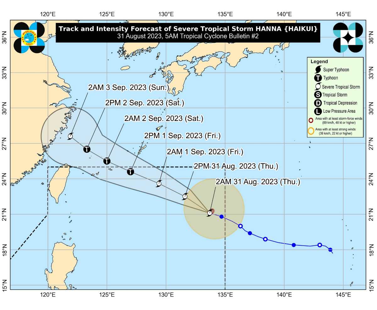
'Bagyong Hanna' is forecast to move generally west northwestward or northwestward at a fairly consistent speed throughout the forecast period.
On the forecast track, this tropical cyclone is forecast to remain far from the Philippine landmass and may exit the Philippine Area of Responsibility (PAR) tomorrow afternoon or evening while approaching the Ryukyu Islands.
Outside the PAR region, 'Hanna' will continue to move over the East China Sea and make landfall over the east coast of mainland China on Sunday. Rapid weakening will ensue following its landfall over mainland China.
This tropical cyclone is forecast to gradually intensify until late Saturday or on early Sunday, when it is expected to reach its peak intensity. It may be upgraded into a typhoon within 36 hours while still inside the PAR region.
HAZARDS AFFECTING LAND AREAS
The Southwest Monsoon currently enhanced by Super Typhoon Saola (Bagyong Goring) (now outside the PAR) at this time is also being slightly enhanced by 'Hanna' and Tropical Storm Kirogi (currently outside the PAR).
The enhanced monsoon will bring occasional to monsoon rains over the western portions of Luzon in the next three days.
The enhanced Southwest Monsoon will continue to bring gusty conditions over the following areas not under any Wind Signal, especially in coastal and upland/mountainous areas exposed to winds:
Today and tomorrow (Friday): Ilocos Region, Cordillera Administrative Region, Zambales, Bataan, Aurora, Bulacan, Metro Manila, CALABARZON, MIMAROPA, Bicol Region, Western Visayas, and the northern portion of Eastern Visayas.
Saturday: Zambales, Bataan, Bulacan, Aurora, Metro Manila, CALABARZON, MIMAROPA, Bicol Region, Western Visayas, and the northern portion of Eastern Visayas.
HAZARDS AFFECTING COASTAL WATERS
'Hanna' is less likely to bring rough sea conditions over any seaboard of the country through the forecast period.
However, due to the Southwest Monsoon that it is slightly enhancing, a Gale Warning is in effect for most seaboards of Luzon and Visayas.
TROPICAL CYCLONES
'Bagyong Hanna' is the eighth tropical cyclone for 2023. It entered PAR on Wednesday night.
SEE ALSO: LIST: Typhoon, tropical cyclone names in the Philippines 2023
On average, there are 20 tropical cyclones that could form or enter the PAR each year. Only half of those are projected to make landfall.
— The Summit Express
At 4:00 am today, the center of the eye of Severe Tropical Storm 'Hanna' was estimated based on all available data at 1,225 km East of Extreme Northern Luzon.
 |
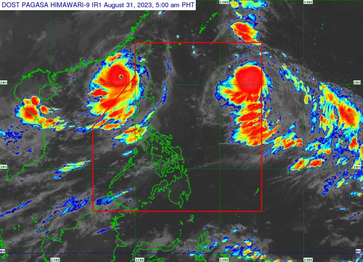
| Satellite image of 'Bagyong Hanna' as of August 31, 2023 5:00 am. Photo courtesy of PAGASA |
'Bagyong Hanna' has maximum sustained winds of 95 km/h near the center, gustiness of up to 115 km/h, and central pressure of 990 hPa. It is moving west northwestward at 20 km/h. Strong to storm-force winds extend outwards up to 340 km from the center.
TROPICAL CYCLONE WIND SIGNALS (TCWS) IN EFFECT
No Wind Signal hoisted at this time.
TRACK AND INTENSITY OUTLOOK
'Bagyong Hanna' is forecast to move generally west northwestward or northwestward at a fairly consistent speed throughout the forecast period.
On the forecast track, this tropical cyclone is forecast to remain far from the Philippine landmass and may exit the Philippine Area of Responsibility (PAR) tomorrow afternoon or evening while approaching the Ryukyu Islands.
Outside the PAR region, 'Hanna' will continue to move over the East China Sea and make landfall over the east coast of mainland China on Sunday. Rapid weakening will ensue following its landfall over mainland China.
This tropical cyclone is forecast to gradually intensify until late Saturday or on early Sunday, when it is expected to reach its peak intensity. It may be upgraded into a typhoon within 36 hours while still inside the PAR region.
HAZARDS AFFECTING LAND AREAS
The Southwest Monsoon currently enhanced by Super Typhoon Saola (Bagyong Goring) (now outside the PAR) at this time is also being slightly enhanced by 'Hanna' and Tropical Storm Kirogi (currently outside the PAR).
The enhanced monsoon will bring occasional to monsoon rains over the western portions of Luzon in the next three days.
The enhanced Southwest Monsoon will continue to bring gusty conditions over the following areas not under any Wind Signal, especially in coastal and upland/mountainous areas exposed to winds:
Today and tomorrow (Friday): Ilocos Region, Cordillera Administrative Region, Zambales, Bataan, Aurora, Bulacan, Metro Manila, CALABARZON, MIMAROPA, Bicol Region, Western Visayas, and the northern portion of Eastern Visayas.
Saturday: Zambales, Bataan, Bulacan, Aurora, Metro Manila, CALABARZON, MIMAROPA, Bicol Region, Western Visayas, and the northern portion of Eastern Visayas.
HAZARDS AFFECTING COASTAL WATERS
'Hanna' is less likely to bring rough sea conditions over any seaboard of the country through the forecast period.
However, due to the Southwest Monsoon that it is slightly enhancing, a Gale Warning is in effect for most seaboards of Luzon and Visayas.
TROPICAL CYCLONES
'Bagyong Hanna' is the eighth tropical cyclone for 2023. It entered PAR on Wednesday night.
SEE ALSO: LIST: Typhoon, tropical cyclone names in the Philippines 2023
On average, there are 20 tropical cyclones that could form or enter the PAR each year. Only half of those are projected to make landfall.
— The Summit Express

