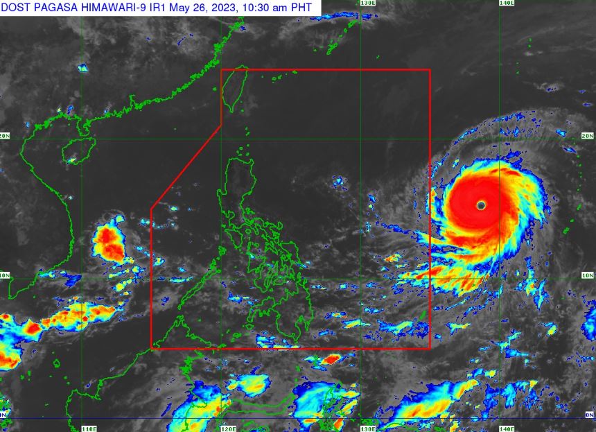
MANILA, Philippines – The super typhoon, which has the international name 'Mawar', slightly intensifies while moving westward over the Philippine Sea, state weather bureau PAGASA announced in its 11:00 am update on Friday, May 26, 2023.
At 10:00 am today, the center of the eye of the Super Typhoon, was estimated based on all available data at 1,705 km East of Southeastern Luzon.
'Mawar' has maximum sustained winds of 215 km/h near the center, gustiness of up to 260 km/h, and central pressure of 905 hPa. It is moving west at 20 km/h.
Strong to typhoon-force winds extend outwards up to 550 km from the center.
The super typhoon is expected to enter the Philippine Area of Responsibility (PAR) tonight or tomorrow early morning (May 27), according to PAGASA. It will be given the local name Betty.
GENERAL OUTLOOK FOR THE FORECAST PERIOD
Super Typhoon 'Mawar' is forecast to track generally west northwestward until Sunday while accelerating before turning northwestward on Sunday.
It will begin to decelerate on Sunday as it begins to move closer towards the waters east of Extreme Northern Luzon.
The center of Mawar’s eye is forecast to be within 250 km of the Batanes-Babuyan archipelago by next week during the slowdown period.
PAGASA added that the super typhoon is forecast to reach its peak intensity within 24 hours. The super typhoon may slightly weaken by tomorrow evening but is expected to remain as a super typhoon until Monday morning due to highly favorable environment.
It will then weaken at a slightly faster rate by late Monday or Tuesday as unfavorable conditions (e.g., increasing wind shear, cooler sea surface temperature resulting from its slowdown by that time, dry air intrusion) take place.
Current forecast scenario shows that the typhoon may bring heavy rains (which may trigger flooding or rain-induced landslides) over Northern Luzon beginning late Sunday or on Monday next week.
In addition, strong to storm-force conditions may be experienced over Extreme Northern Luzon, while strong to gale-force conditions are possible over the northern and eastern portions of Northern Luzon mainland. As a result, wind signals will be raised by tomorrow evening in preparation for these severe winds.
'Mawar' is also forecast to enhance the Southwest Monsoon which may bring monsoon rains over the western portions of Central Luzon, Southern Luzon, and Visayas beginning on Sunday or Monday.
PAGASA is expected to soon declare the start of the country’s rainy season, which usually begins in the second half of May or first half of June.
— The Summit Express
At 10:00 am today, the center of the eye of the Super Typhoon, was estimated based on all available data at 1,705 km East of Southeastern Luzon.
 |
| Satellite image of Super Typhoon 'Mawar' as of 10:30 am, May 26, 2023. PAGASA |
'Mawar' has maximum sustained winds of 215 km/h near the center, gustiness of up to 260 km/h, and central pressure of 905 hPa. It is moving west at 20 km/h.
Strong to typhoon-force winds extend outwards up to 550 km from the center.
The super typhoon is expected to enter the Philippine Area of Responsibility (PAR) tonight or tomorrow early morning (May 27), according to PAGASA. It will be given the local name Betty.
GENERAL OUTLOOK FOR THE FORECAST PERIOD
Super Typhoon 'Mawar' is forecast to track generally west northwestward until Sunday while accelerating before turning northwestward on Sunday.
It will begin to decelerate on Sunday as it begins to move closer towards the waters east of Extreme Northern Luzon.
The center of Mawar’s eye is forecast to be within 250 km of the Batanes-Babuyan archipelago by next week during the slowdown period.
PAGASA added that the super typhoon is forecast to reach its peak intensity within 24 hours. The super typhoon may slightly weaken by tomorrow evening but is expected to remain as a super typhoon until Monday morning due to highly favorable environment.
It will then weaken at a slightly faster rate by late Monday or Tuesday as unfavorable conditions (e.g., increasing wind shear, cooler sea surface temperature resulting from its slowdown by that time, dry air intrusion) take place.
Current forecast scenario shows that the typhoon may bring heavy rains (which may trigger flooding or rain-induced landslides) over Northern Luzon beginning late Sunday or on Monday next week.
In addition, strong to storm-force conditions may be experienced over Extreme Northern Luzon, while strong to gale-force conditions are possible over the northern and eastern portions of Northern Luzon mainland. As a result, wind signals will be raised by tomorrow evening in preparation for these severe winds.
'Mawar' is also forecast to enhance the Southwest Monsoon which may bring monsoon rains over the western portions of Central Luzon, Southern Luzon, and Visayas beginning on Sunday or Monday.
PAGASA is expected to soon declare the start of the country’s rainy season, which usually begins in the second half of May or first half of June.
— The Summit Express

