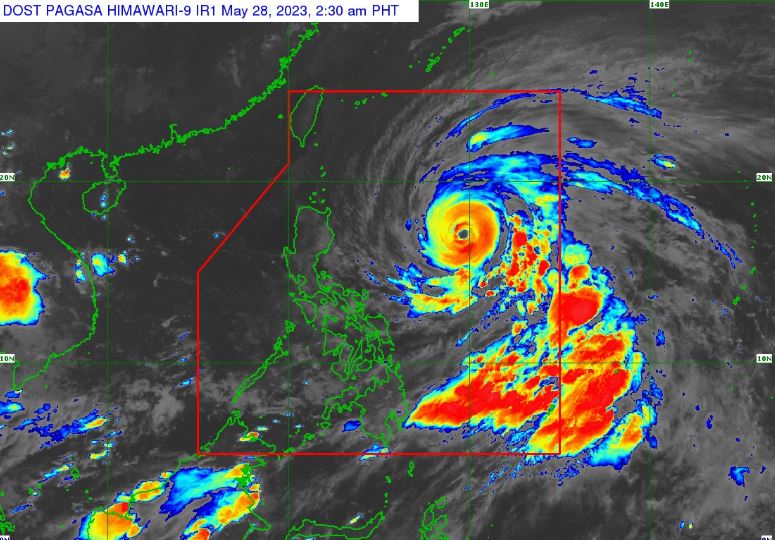
MANILA, Philippines – 'Bagyong Betty' (international name: Mawar) maintains its strength while moving over the Philippine Sea East of Northern Luzon, state weather bureau PAGASA announced in its 5:00 am update on Sunday, May 28, 2023.
At 4:00 am today, the center of Typhoon 'Betty' was estimated based on all available data at 815 km East of Northern Luzon.
'Bagyong Betty' has maximum sustained winds of 175 km/h near the center, gustiness of up to 215 km/h, and central pressure of 935 hPa. It is moving west northwestward at 20 km/h.
Strong to typhoon-force winds extend outwards up to 740 km from the center.
TROPICAL CYCLONE WIND SIGNALS (TCWS) IN EFFECT
TCWS No. 1
Luzon
NOTE: Wind Signal No. 2 remains the most likely highest wind signal that will be hoisted, while Wind Signal No. 3 remains the reasonable worst-case scenario.
TRACK AND INTENSITY OUTLOOK
'Betty' will move west northwestward or northwestward until tomorrow while gradually decelerating.
The typhoon will likely become slow-moving to almost stationary by Tuesday while over the waters east of Batanes.
It will then move northward or north northeastward by mid Wednesday or Thursday towards the sea east of Taiwan.
This typhoon will likely remain as a typhoon throughout the forecast period, although it is expected to gradually weaken until Tuesday. Afterwards, increasingly unfavorable environment while moving northward or north northeastward on Wednesday or Thursday will result in a faster weakening rate.
It may be downgraded to severe tropical storm category on late Thursday or early Friday.
PAGASA said that Typhoon 'Betty' will also enhance the Southwest Monsoon this week:
Tomorrow: Monsoon rains are possible over the western portions of MIMAROPA and Western Visayas
Tuesday: Monsoon rains are likely over the western portions of MIMAROPA and Western Visayas
Wednesday: Monsoon rains are likely over the western portions of MIMAROPA and Western Visayas.
TROPICAL CYCLONES
'Bagyong Betty' is the second tropical cyclone for 2023, known as the strongest Northern Hemisphere cyclone to form in the month of May. It originated from an area of low-pressure south-southwest of Chuuk Lagoon in the central Pacific that developed into a tropical depression on May 19.
SEE ALSO: LIST: Typhoon, tropical cyclone names in the Philippines 2023
On average, there are 20 tropical cyclones that could form or enter the PAR each year. Only half of those are projected to make landfall.
PAGASA is expected to soon declare the start of the country’s rainy season, which usually begins in the second half of May or first half of June.
— The Summit Express
At 4:00 am today, the center of Typhoon 'Betty' was estimated based on all available data at 815 km East of Northern Luzon.
 |
| Satellite image of Typhoon 'Betty' as of 2:30 am, May 28, 2023. PAGASA |
'Bagyong Betty' has maximum sustained winds of 175 km/h near the center, gustiness of up to 215 km/h, and central pressure of 935 hPa. It is moving west northwestward at 20 km/h.
Strong to typhoon-force winds extend outwards up to 740 km from the center.
TROPICAL CYCLONE WIND SIGNALS (TCWS) IN EFFECT
TCWS No. 1
Luzon
- Batanes
- Cagayan including Babuyan Islands
- Isabela
- Apayao
- Ilocos Norte
- the northern and central portions of Abra (Tineg, Lacub, Lagayan, San Juan, Lagangilang, Licuan-Baay, Malibcong, Danglas, La Paz, Dolores, Tayum, Bucay, Sallapadan, Daguioman, Bucloc, Boliney)
- Kalinga
- the eastern and central portions of Mountain Province (Sadanga, Barlig, Natonin, Paracelis, Bontoc)
- the eastern and central portions of Ifugao (Mayoyao, Aguinaldo, Alfonso Lista, Banaue, Hingyon, Lagawe, Lamut, Kiangan, Asipulo)
- the northern and central portions of Aurora (Dilasag, Casiguran, Dinalungan, Dipaculao)
- Quirino
- the northeastern portion of Nueva Vizcaya (Kasibu, Quezon, Solano, Bagabag, Diadi, Villaverde, Bayombong, Ambaguio)
NOTE: Wind Signal No. 2 remains the most likely highest wind signal that will be hoisted, while Wind Signal No. 3 remains the reasonable worst-case scenario.
TRACK AND INTENSITY OUTLOOK
'Betty' will move west northwestward or northwestward until tomorrow while gradually decelerating.
The typhoon will likely become slow-moving to almost stationary by Tuesday while over the waters east of Batanes.
It will then move northward or north northeastward by mid Wednesday or Thursday towards the sea east of Taiwan.
This typhoon will likely remain as a typhoon throughout the forecast period, although it is expected to gradually weaken until Tuesday. Afterwards, increasingly unfavorable environment while moving northward or north northeastward on Wednesday or Thursday will result in a faster weakening rate.
It may be downgraded to severe tropical storm category on late Thursday or early Friday.
PAGASA said that Typhoon 'Betty' will also enhance the Southwest Monsoon this week:
Tomorrow: Monsoon rains are possible over the western portions of MIMAROPA and Western Visayas
Tuesday: Monsoon rains are likely over the western portions of MIMAROPA and Western Visayas
Wednesday: Monsoon rains are likely over the western portions of MIMAROPA and Western Visayas.
TROPICAL CYCLONES
'Bagyong Betty' is the second tropical cyclone for 2023, known as the strongest Northern Hemisphere cyclone to form in the month of May. It originated from an area of low-pressure south-southwest of Chuuk Lagoon in the central Pacific that developed into a tropical depression on May 19.
SEE ALSO: LIST: Typhoon, tropical cyclone names in the Philippines 2023
On average, there are 20 tropical cyclones that could form or enter the PAR each year. Only half of those are projected to make landfall.
PAGASA is expected to soon declare the start of the country’s rainy season, which usually begins in the second half of May or first half of June.
— The Summit Express

