MANILA, Philippines – 'Bagyong Amang' is moving west northwestward along the coast of Camarines Norte, state weather bureau PAGASA announced in its 5:00 am update on Thursday, April 13, 2023.
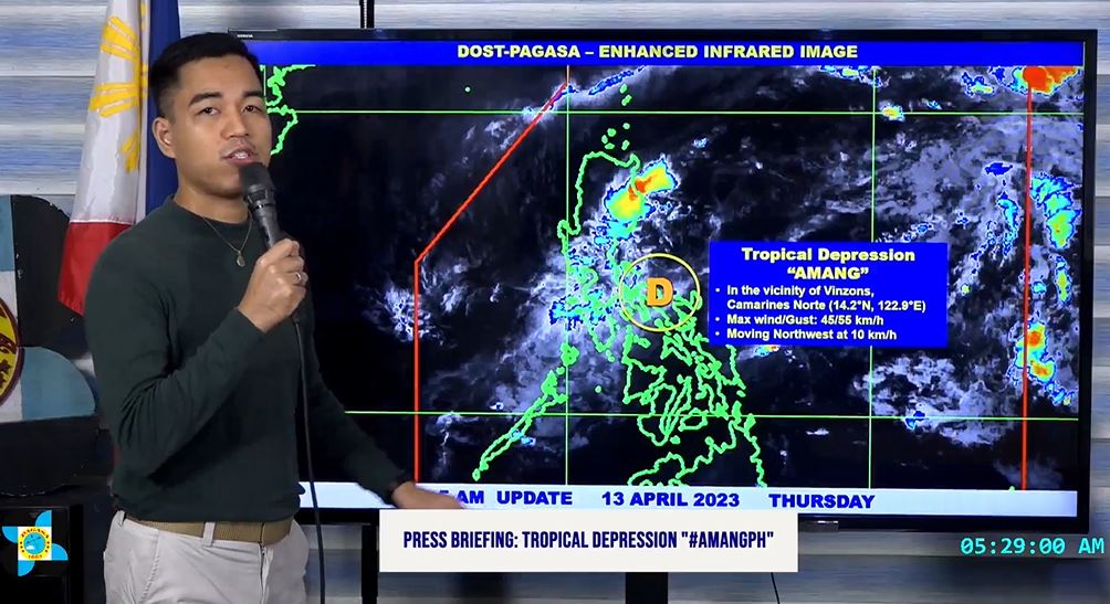
At 4:00 am today, the center of Tropical Depression 'Amang' was estimated based on all available data in the vicinity of Vinzons, Camarines Norte.
'Bagyong Amang' has a maximum sustained winds of 45 km/h near the center, gustiness of up to 55 km/h, and central pressure of 1006 hPa.
It is moving west northwestward at 10 km/h.
Strong winds extend outwards up to 150 km from the center.
TROPICAL CYCLONE WIND SIGNALS (TCWS)
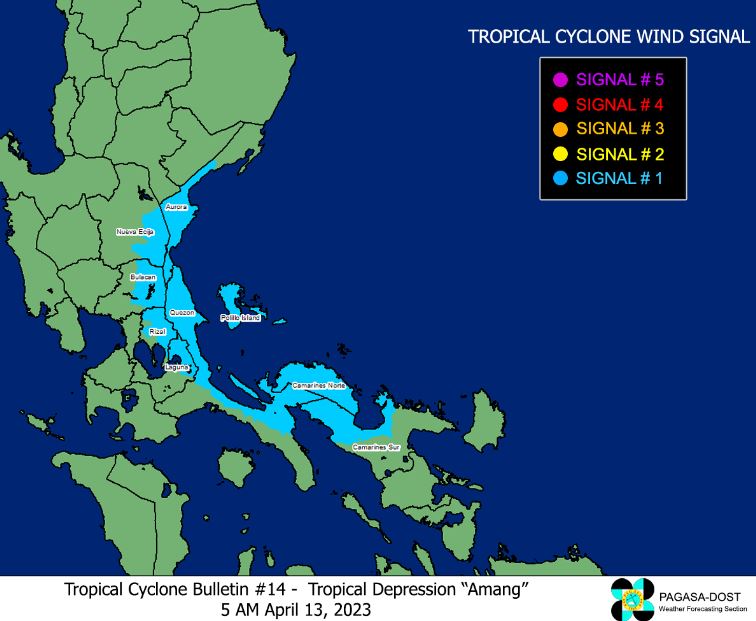
TCWS No. 1 (Strong winds prevailing or expected within the next 36 hours)
TRACK AND INTENSITY OUTLOOK
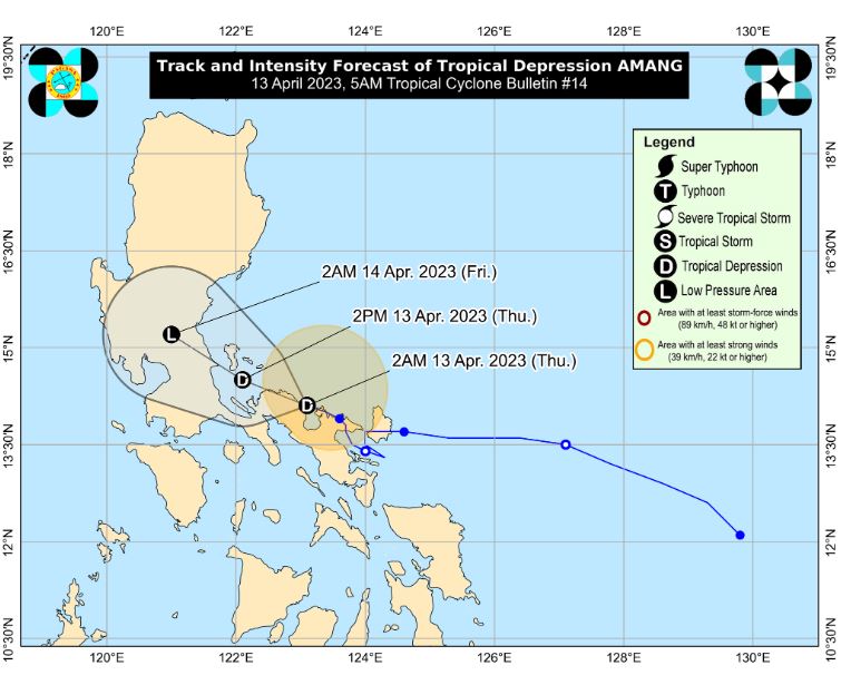
'Amang' is forecast to weaken into a low pressure area within the day as it moves over Camarines Norte towards Lamon Bay, Polillo Islands, and the northern portion of mainland Quezon.
HAZARDS AFFECTING LAND AREAS
Heavy Rainfall Outlook
Forecast accumulated rainfall for the next 24 hours (from this early morning to tomorrow early morning):
Up to 25 mm in most areas of Central Luzon, Metro Manila, and CALABARZON, reaching 50 mm in a few locations (mostly in Central Luzon and northern Quezon) caused by scattered rainshowers and thunderstorms.
Under these conditions, isolated flashfloods and rain-induced landslides remains possible, especially in areas that are highly or very highly susceptible to these hazards as identified in hazard maps and in localities that experienced considerable amounts of rainfall for the past several days.
Severe Winds
Areas under Wind Signal No. 1 may experience strong winds (strong breeze to near gale strength) associated with the tropical depression which may cause minimal to minor impacts to life and property.
HAZARDS AFFECTING COASTAL WATERS
In the next 24 hours, moderate to rough seas (1.2 to 3.0 m) may be experienced over the western seaboards of Northern Luzon, and the northern and eastern seaboards of Luzon.
Mariners of small seacrafts are advised to take precautionary measures when venturing out to sea and, if possible, avoid navigating in these conditions.
'Bagyong Amang' is the first tropical cyclone for 2023, developed from Low Pressure Area (LPA) east of Catanduanes on Tuesday, April 11, 2023.
On average, there are 20 tropical cyclones that could form or enter the PAR each year. Only half of those are projected to make landfall.
— The Summit Express
 |
| DOST-PAGASA Weather Specialist Benison Estareja gives update on Tropical Depression 'Amang' |
At 4:00 am today, the center of Tropical Depression 'Amang' was estimated based on all available data in the vicinity of Vinzons, Camarines Norte.
'Bagyong Amang' has a maximum sustained winds of 45 km/h near the center, gustiness of up to 55 km/h, and central pressure of 1006 hPa.
It is moving west northwestward at 10 km/h.
Strong winds extend outwards up to 150 km from the center.
TROPICAL CYCLONE WIND SIGNALS (TCWS)
TCWS No. 1 (Strong winds prevailing or expected within the next 36 hours)
- Camarines Norte
- the northwestern portion of Camarines Sur (Sipocot, Cabusao, Bombon, Calabanga, Tinambac, Siruma, Lupi, Ragay, Del Gallego)
- the eastern portion of Laguna (Cavinti, Kalayaan, Paete, Pangil, Siniloan, Famy, Santa Maria, Lumban, Pakil, Mabitac)
- the northern and eastern portions of Quezon (Calauag, Infanta, Lopez, Plaridel, Quezon, Alabat, Sampaloc, Mauban, General Nakar, Perez, Gumaca, Atimonan, Real, Tagkawayan, Guinayangan) including Polillo Islands
- the eastern portion of Rizal (Tanay, Rodriguez)
- the eastern portion of Bulacan (Norzagaray, Doña Remedios Trinidad)
- the eastern portion of Nueva Ecija (Gabaldon, General Tinio)
- the central and southern portions of Aurora (Dingalan, Baler, Maria Aurora, San Luis, Dipaculao)
TRACK AND INTENSITY OUTLOOK
'Amang' is forecast to weaken into a low pressure area within the day as it moves over Camarines Norte towards Lamon Bay, Polillo Islands, and the northern portion of mainland Quezon.
HAZARDS AFFECTING LAND AREAS
Heavy Rainfall Outlook
Forecast accumulated rainfall for the next 24 hours (from this early morning to tomorrow early morning):
Up to 25 mm in most areas of Central Luzon, Metro Manila, and CALABARZON, reaching 50 mm in a few locations (mostly in Central Luzon and northern Quezon) caused by scattered rainshowers and thunderstorms.
Under these conditions, isolated flashfloods and rain-induced landslides remains possible, especially in areas that are highly or very highly susceptible to these hazards as identified in hazard maps and in localities that experienced considerable amounts of rainfall for the past several days.
Severe Winds
Areas under Wind Signal No. 1 may experience strong winds (strong breeze to near gale strength) associated with the tropical depression which may cause minimal to minor impacts to life and property.
HAZARDS AFFECTING COASTAL WATERS
In the next 24 hours, moderate to rough seas (1.2 to 3.0 m) may be experienced over the western seaboards of Northern Luzon, and the northern and eastern seaboards of Luzon.
Mariners of small seacrafts are advised to take precautionary measures when venturing out to sea and, if possible, avoid navigating in these conditions.
Press Briefing: Tropical Depression "#AmangPH" Update Thursday 5AM April 13, 2023Press Briefing: Tropical Depression "#AmangPH" Update Thursday 5 AM April 13, 2023 DOST-PAGASA Weather Specialist: Benison Estareja #AmangPH #WeatherReport #DOSTpagasa
Posted by Dost_pagasa on Wednesday, April 12, 2023
'Bagyong Amang' is the first tropical cyclone for 2023, developed from Low Pressure Area (LPA) east of Catanduanes on Tuesday, April 11, 2023.
On average, there are 20 tropical cyclones that could form or enter the PAR each year. Only half of those are projected to make landfall.
— The Summit Express


