MANILA, Philippines – The Low Pressure Area (LPA) east of Catanduanes developed into Tropical Depression 'Amang', the first tropical cyclone for 2023, state weather bureau PAGASA announced in its 5:00 am update on Tuesday, April 11, 2023.
At 4:00 am today, the center of 'Bagyong Amang' was estimated based on all available data at 475 km East of Virac, Catanduanes.
SEE ALSO: 'Bagyong Amang' PAGASA weather update April 12, 2023
 |
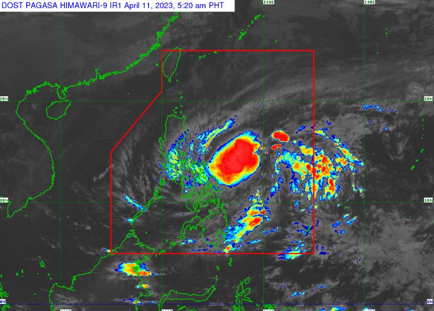
| Satellite image of 'Bagyong Amang' as of 5:20 am, April 11, 2023. Photo courtesy of DOST-PAGASA |
At 4:00 am today, the center of 'Bagyong Amang' was estimated based on all available data at 475 km East of Virac, Catanduanes.
SEE ALSO: 'Bagyong Amang' PAGASA weather update April 12, 2023
'Bagyong Amang' has a maximum sustained winds of 45 km/h near the center, gustiness of up to 55 km/h, and central pressure of 1004 hPa.
It is moving west northwestward at 20 km/h.
Strong winds extend outwards up to 300 km from the center.
TROPICAL CYCLONE WIND SIGNALS (TCWS)
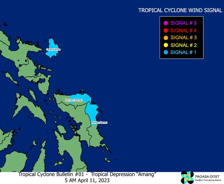
TCWS No. 1 (Strong winds prevailing or expected within the next 36 hours)
LUZON
VISAYAS
TRACK AND INTENSITY OUTLOOK
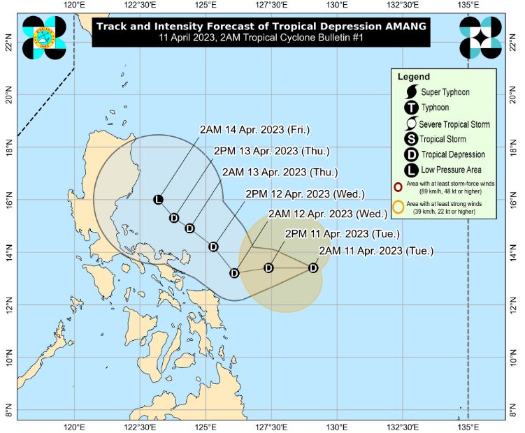
For the next 24 hours, 'Amang' is forecast to track generally westward towards Bicol Region before turning northwestward for the remainder of the forecast period.
While the current track forecast shows that the tropical depression will remain offshore over the waters east of Luzon for the next 3 days, the forecast confidence cone shows that a landfall scenario over the Bicol Peninsula area or the northern portion of Samar Island is not ruled out, especially for the next 36 hours.
Throughout the forecast period, 'Amang' is forecast to remain as a tropical depression, with the possibility of weakening into a low pressure area by late Thursday or early Friday.
HAZARDS AFFECTING LAND AREAS
Heavy Rainfall Outlook
Forecast accumulated rainfall from this morning until tonight
Under these conditions, flooding and rain-induced landslides are possible, especially in areas that are highly or very highly susceptible to these hazard as identified in hazard maps and in localities that experienced considerable amounts of rainfall for the past several days.
Severe Winds
Areas under Wind Signal No. 1 may experience strong winds (strong breeze to near gale strength) associated with Tropical Depression 'Amang' which may pose minimal to minor threat to life and property
Wind Signal No. 1 may be hoisted in other localities in Eastern Visayas and Bicol Region in succeeding bulletins.
HAZARDS AFFECTING COASTAL WATERS
Under the influence of the Tropical Depression, a marine gale warning is in effect over the eastern seaboards of Catanduanes and Eastern Samar, and the northern and eastern seaboards of Northern Samar.
In the next 24 hours, moderate to rough seas (1.2 to 2m over the eastern seaboards of Central Luzon, Southern Luzon, and Eastern Visayas that are not under any gale warning. Mariners of small seacrafts are advised to take precautionary measures when venturing out to sea and, if possible, avoid navigating in these conditions.
TROPICAL CYCLONES
On average, there are 20 tropical cyclones that could form or enter the PAR each year. Only half of those are projected to make landfall.
— The Summit Express
It is moving west northwestward at 20 km/h.
Strong winds extend outwards up to 300 km from the center.
TROPICAL CYCLONE WIND SIGNALS (TCWS)
TCWS No. 1 (Strong winds prevailing or expected within the next 36 hours)
LUZON
- Catanduanes
VISAYAS
- the northern portion of Eastern Samar (Taft, Can-Avid, Sulat, Dolores, Oras, Arteche, San Policarpo, Jipapad, Maslog, San Julian)
- the eastern portion of Northern Samar (Catubig, Lapinig, Gamay, Mapanas, Palapag, Laoang, San Roque, Pambujan, Mondragon)
TRACK AND INTENSITY OUTLOOK
For the next 24 hours, 'Amang' is forecast to track generally westward towards Bicol Region before turning northwestward for the remainder of the forecast period.
While the current track forecast shows that the tropical depression will remain offshore over the waters east of Luzon for the next 3 days, the forecast confidence cone shows that a landfall scenario over the Bicol Peninsula area or the northern portion of Samar Island is not ruled out, especially for the next 36 hours.
Throughout the forecast period, 'Amang' is forecast to remain as a tropical depression, with the possibility of weakening into a low pressure area by late Thursday or early Friday.
HAZARDS AFFECTING LAND AREAS
Heavy Rainfall Outlook
Forecast accumulated rainfall from this morning until tonight
- Heavy rains (50-100 mm): Northern Samar and the northern portions of Samar and Eastern Samar
- Forecast accumulated rainfall from this morning until Thursday evening
- Intense rains (100-200 mm): Camarines Norte and the western portion of Camarines Sur
- Heavy rains (50-100 mm): The southern portion of Quezon, the rest of Bicol Region, Northern Samar and the northern portions of Samar and Eastern Samar
Under these conditions, flooding and rain-induced landslides are possible, especially in areas that are highly or very highly susceptible to these hazard as identified in hazard maps and in localities that experienced considerable amounts of rainfall for the past several days.
Severe Winds
Areas under Wind Signal No. 1 may experience strong winds (strong breeze to near gale strength) associated with Tropical Depression 'Amang' which may pose minimal to minor threat to life and property
Wind Signal No. 1 may be hoisted in other localities in Eastern Visayas and Bicol Region in succeeding bulletins.
HAZARDS AFFECTING COASTAL WATERS
Under the influence of the Tropical Depression, a marine gale warning is in effect over the eastern seaboards of Catanduanes and Eastern Samar, and the northern and eastern seaboards of Northern Samar.
In the next 24 hours, moderate to rough seas (1.2 to 2m over the eastern seaboards of Central Luzon, Southern Luzon, and Eastern Visayas that are not under any gale warning. Mariners of small seacrafts are advised to take precautionary measures when venturing out to sea and, if possible, avoid navigating in these conditions.
TROPICAL CYCLONES
On average, there are 20 tropical cyclones that could form or enter the PAR each year. Only half of those are projected to make landfall.
— The Summit Express


