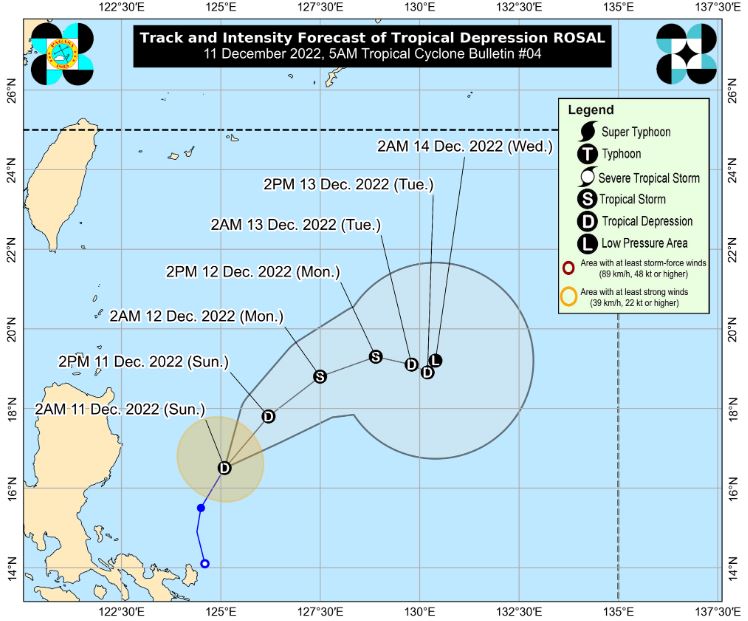
MANILA, Philippines – 'Bagyong Rosal' continues to maintain its strength over the Philippine Sea east of Aurora, state weather bureau PAGASA announced in its 5:00 am update on Sunday, December 11, 2022.
'Rosal' is the Philippines’ 18th tropical cyclone for 2022. It developed into a tropical depression Saturday morning, December 10.
At 4:00 am today, the center of Tropical Depression 'Rosal' was estimated based on all available data at 330 km East of Casiguran, Aurora.
'Bagyong Rosal' has maximum sustained winds of 45 km/h near the center, gustiness of up to 55 km/h, and central pressure of 1002 hPa. It is moving north northeastward at 20 km/h.
Strong winds extend outwards up to 150 km from the center.
TRACK AND INTENSITY OUTLOOK
'Rosal' is forecast to move generally northeastward today through tomorrow morning before turning east southeastward.
In the near term, the tropical depression may still intensify into a low-end tropical storm within the next 36 hours. However, increasingly unfavorable conditions associated within the monsoon surge by late Monday or early Tuesday will result in a weakening trend.
It may become a post-tropical low embedded along the leading edge of the monsoon surge by Wednesday.
HAZARDS AFFECTING LAND AREAS
Heavy Rainfall
Until this noon: Light to moderate with at times heavy rains over MIMAROPA.
Under these conditions, flooding and rain-induced landslides are still possible in some areas, especially in areas that are highly or very highly susceptible to these hazard as identified in hazard maps and in localities with significant antecedent rainfall.
Severe Winds
In the next 24 hours, the surge of the Northeast Monsoon partly enhanced by this tropical depression may bring occasional gusts reaching gale-force over Batanes and Babuyan Islands, and strong breeze to near-gale strength over the Ilocos Norte, the northern and eastern portions of Cagayan, the eastern portion of Isabela, Calaguas Islands, and the extreme northern portion of Catanduanes.
HAZARDS AFFECTING COASTAL WATERS
Under the influence of the surge of the Northeast Monsoon partly enhanced by 'Rosal', a marine gale warning is in effect over the seaboards of Northern Luzon.
In the next 24 hours, the combined effects of the surge of the Northeast Monsoon and the tropical cyclone may also bring moderate to rough seas (1.5 to 3.5 m) over the seaboards of Central Luzon and the eastern and western seaboards of Southern Luzon.
These conditions may be risky for those using small seacrafts. Mariners are advised to take precautionary measures when venturing out to sea and, if possible, avoid navigating in these conditions.
— The Summit Express
'Rosal' is the Philippines’ 18th tropical cyclone for 2022. It developed into a tropical depression Saturday morning, December 10.
At 4:00 am today, the center of Tropical Depression 'Rosal' was estimated based on all available data at 330 km East of Casiguran, Aurora.
 |
| Satellite image of Tropical Depression 'Rosal' as of 4:40 am, December 11, 2022. PAGASA |
'Bagyong Rosal' has maximum sustained winds of 45 km/h near the center, gustiness of up to 55 km/h, and central pressure of 1002 hPa. It is moving north northeastward at 20 km/h.
Strong winds extend outwards up to 150 km from the center.
TRACK AND INTENSITY OUTLOOK
'Rosal' is forecast to move generally northeastward today through tomorrow morning before turning east southeastward.
In the near term, the tropical depression may still intensify into a low-end tropical storm within the next 36 hours. However, increasingly unfavorable conditions associated within the monsoon surge by late Monday or early Tuesday will result in a weakening trend.
It may become a post-tropical low embedded along the leading edge of the monsoon surge by Wednesday.
HAZARDS AFFECTING LAND AREAS
Heavy Rainfall
Until this noon: Light to moderate with at times heavy rains over MIMAROPA.
Under these conditions, flooding and rain-induced landslides are still possible in some areas, especially in areas that are highly or very highly susceptible to these hazard as identified in hazard maps and in localities with significant antecedent rainfall.
Severe Winds
In the next 24 hours, the surge of the Northeast Monsoon partly enhanced by this tropical depression may bring occasional gusts reaching gale-force over Batanes and Babuyan Islands, and strong breeze to near-gale strength over the Ilocos Norte, the northern and eastern portions of Cagayan, the eastern portion of Isabela, Calaguas Islands, and the extreme northern portion of Catanduanes.
HAZARDS AFFECTING COASTAL WATERS
Under the influence of the surge of the Northeast Monsoon partly enhanced by 'Rosal', a marine gale warning is in effect over the seaboards of Northern Luzon.
In the next 24 hours, the combined effects of the surge of the Northeast Monsoon and the tropical cyclone may also bring moderate to rough seas (1.5 to 3.5 m) over the seaboards of Central Luzon and the eastern and western seaboards of Southern Luzon.
These conditions may be risky for those using small seacrafts. Mariners are advised to take precautionary measures when venturing out to sea and, if possible, avoid navigating in these conditions.
— The Summit Express

