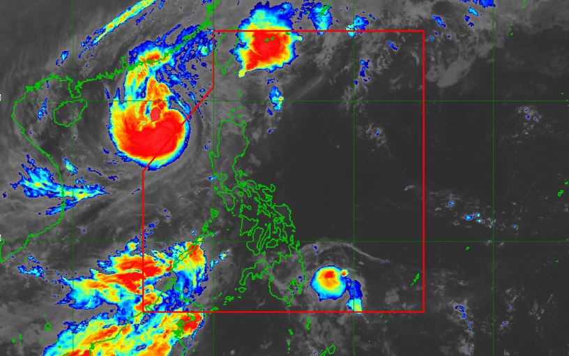
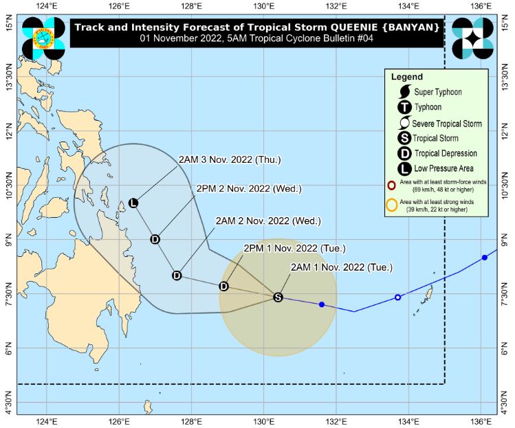
MANILA, Philippines – 'Bagyong Queenie' (international name: Banyan) moves westward over the Philippine Sea east of Mindanao, state weather bureau PAGASA announced in its 5:00 am update on Tuesday, November 1, 2022.
At 4:00 am today, the center of Tropical Storm 'Queenie' was estimated based on all available data at 490 km East of Davao City.
'Bagyong Queenie' has maximum sustained winds of 65 km/h near the center, gustiness of up to 80 km/h, and central pressure of 1000 hPa. It is moving west westward at 20 km/h.
Strong to gale-force winds extend outwards up to 180 km from the center.
No Tropical Cyclone Wind Signals is currently in effect.
TRACK AND INTENSITY OUTLOOK
Tropical Storm 'Queenie' is forecast to track generally west northwestward to northwestward today before turning north northwestward tomorrow while over the sea east of Caraga-Davao Region area.
It may weaken into a tropical depression today due to increasingly unfavorable conditions.
Further weakening into a low pressure area is likely by Thursday, possibly earlier.
HAZARDS AFFECTING LAND AREAS
Heavy Rainfall
Tonight through tomorrow: Moderate to heavy rains possible over Surigao del Norte, Surigao del Sur, and Dinagat Islands.
Light to moderate with at times heavy rains possible over Eastern Visayas, Davao Oriental, and the rest of Caraga Region.
Thursday: Light to moderate with at times heavy rains possible over Caraga, Davao Region, Northern Mindanao, Eastern Visayas, Central Visayas, and Bicol Region.
Under these conditions, flooding and rain-induced landslides are possible, especially in areas that are highly or very highly susceptible to these hazard as identified in hazard maps and in localities with significant antecedent rainfall.
Severe Winds
Despite the weakening scenario within the forecast period, the hoisting of Tropical Cyclone Wind Signals is not ruled out over the eastern portion of Caraga and in some areas in Eastern Visayas today.
Per latest track and intensity forecast, the highest wind signal that will likely be hoisted is Wind Signal No. 1.
HAZARDS AFFECTING COASTAL WATERS
In the next 24 hours, under the influence of 'Queenie', moderate to rough seas (1.5 to 3.0 m) may prevail over the eastern seaboard of Mindanao.
These conditions may be risky for those using small seacrafts.
Mariners are advised to take precautionary measures when venturing out to sea and, if possible, avoid navigating in these conditions.
TROPICAL CYCLONES
'Queenie' is the Philippines’ 17th tropical cyclone for 2022. It entered the Philippine Area of Responsibility (PAR) at 5:00 am on Monday, October 31.
On average, there are 20 tropical cyclones that could form or enter the PAR each year. Only half of those are projected to make landfall.
— The Summit Express
At 4:00 am today, the center of Tropical Storm 'Queenie' was estimated based on all available data at 490 km East of Davao City.
 |
| Satellite image of Tropical Storm 'Queenie' as of 4:30 am, November 1, 2022. PAGASA |
'Bagyong Queenie' has maximum sustained winds of 65 km/h near the center, gustiness of up to 80 km/h, and central pressure of 1000 hPa. It is moving west westward at 20 km/h.
Strong to gale-force winds extend outwards up to 180 km from the center.
No Tropical Cyclone Wind Signals is currently in effect.
TRACK AND INTENSITY OUTLOOK
Tropical Storm 'Queenie' is forecast to track generally west northwestward to northwestward today before turning north northwestward tomorrow while over the sea east of Caraga-Davao Region area.
It may weaken into a tropical depression today due to increasingly unfavorable conditions.
Further weakening into a low pressure area is likely by Thursday, possibly earlier.
HAZARDS AFFECTING LAND AREAS
Heavy Rainfall
Tonight through tomorrow: Moderate to heavy rains possible over Surigao del Norte, Surigao del Sur, and Dinagat Islands.
Light to moderate with at times heavy rains possible over Eastern Visayas, Davao Oriental, and the rest of Caraga Region.
Thursday: Light to moderate with at times heavy rains possible over Caraga, Davao Region, Northern Mindanao, Eastern Visayas, Central Visayas, and Bicol Region.
Under these conditions, flooding and rain-induced landslides are possible, especially in areas that are highly or very highly susceptible to these hazard as identified in hazard maps and in localities with significant antecedent rainfall.
Severe Winds
Despite the weakening scenario within the forecast period, the hoisting of Tropical Cyclone Wind Signals is not ruled out over the eastern portion of Caraga and in some areas in Eastern Visayas today.
Per latest track and intensity forecast, the highest wind signal that will likely be hoisted is Wind Signal No. 1.
HAZARDS AFFECTING COASTAL WATERS
In the next 24 hours, under the influence of 'Queenie', moderate to rough seas (1.5 to 3.0 m) may prevail over the eastern seaboard of Mindanao.
These conditions may be risky for those using small seacrafts.
Mariners are advised to take precautionary measures when venturing out to sea and, if possible, avoid navigating in these conditions.
TROPICAL CYCLONES
'Queenie' is the Philippines’ 17th tropical cyclone for 2022. It entered the Philippine Area of Responsibility (PAR) at 5:00 am on Monday, October 31.
On average, there are 20 tropical cyclones that could form or enter the PAR each year. Only half of those are projected to make landfall.
— The Summit Express

