MANILA, Philippines – 'Bagyong Queenie' has intensified into a tropical storm, state weather bureau PAGASA announced in its 11:00 am update on Monday, October 31, 2022.
SEE ALSO: 'Bagyong Queenie' PAGASA weather update November 1, 2022
SEE ALSO: 'Bagyong Queenie' PAGASA weather update November 1, 2022
Tropical Storm 'Queenie' entered the Philippine Area of Responsibility (PAR) at 5:00 am today.
At 10:00 am today, the center of 'Queenie' was estimated based on all available data at 815 km East of Northeastern Mindanao.
'Bagyong Queenie' has maximum sustained winds of 65 km/h near the center, gustiness of up to 80 km/h, and central pressure of 1000 hPa. It is moving west southwestward at 10 km/h.
Strong to gale-force winds extend outwards up to 220 km from the center.
No Tropical Cyclone Wind Signals is currently in effect.
TRACK AND INTENSITY OUTLOOK
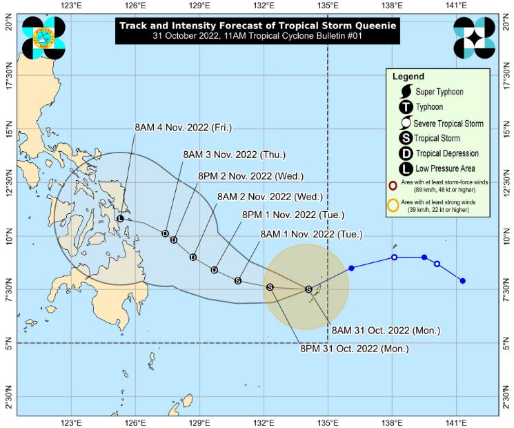
'Queenie' is forecast to track westward in the next 12 hours before turning generally west northwestward tomorrow through Wednesday morning.
By Wednesday afternoon, this storm will begin to move generally northwestward towards Caraga-Eastern Visayas area.
The new cyclone intensified into a tropical storm at 8:00 am today. It may further intensify in the next 12 hours. However, weakening trend is likely by tomorrow evening or Wednesday.
Weakening into a remnant low is likely on Friday as it approaches Caraga or Eastern Visayas.
Meanwhile, Severe Tropical Storm 'Paeng' (Nalgae) is forecast to exit the PAR this afternoon or evening.
HAZARDS AFFECTING LAND AREAS
Heavy Rainfall
'Queenie' is unlikely to directly affect the country until Tuesday. However, light to moderate with at times heavy rains possible over Caraga, Eastern Visayas, and Bicol Region beginning Wednesday.
Severe Winds
Based on the latest forecast scenario, Tropical Cyclone Wind Signal may be hoisted over the eastern portion of Caraga and in some areas in Eastern Visayas tomorrow evening at the earliest.
Per latest track and intensity forecast, the most likely highest wind signal that will be hoisted is Wind Signal No. 1.
HAZARDS AFFECTING COASTAL WATERS
In the next 24 hours, 'Queenie' is less likely to bring roughs seas over the coastal waters of the country which may result to risky conditions to mariners.
TROPICAL CYCLONES
'Queenie' is the Philippines’ 17th tropical cyclone for 2022.
On average, there are 20 tropical cyclones that could form or enter the PAR each year. Only half of those are projected to make landfall.
— The Summit Express
 |
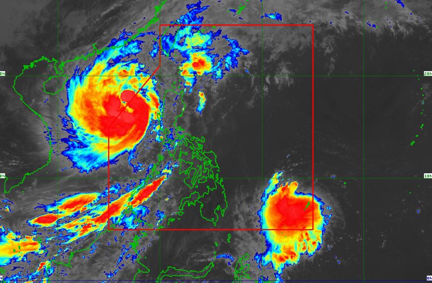
| Satellite image of Tropical Storm 'Queenie' as of 11:30 am, October 31, 2022. PAGASA |
At 10:00 am today, the center of 'Queenie' was estimated based on all available data at 815 km East of Northeastern Mindanao.
'Bagyong Queenie' has maximum sustained winds of 65 km/h near the center, gustiness of up to 80 km/h, and central pressure of 1000 hPa. It is moving west southwestward at 10 km/h.
Strong to gale-force winds extend outwards up to 220 km from the center.
No Tropical Cyclone Wind Signals is currently in effect.
TRACK AND INTENSITY OUTLOOK
'Queenie' is forecast to track westward in the next 12 hours before turning generally west northwestward tomorrow through Wednesday morning.
By Wednesday afternoon, this storm will begin to move generally northwestward towards Caraga-Eastern Visayas area.
The new cyclone intensified into a tropical storm at 8:00 am today. It may further intensify in the next 12 hours. However, weakening trend is likely by tomorrow evening or Wednesday.
Weakening into a remnant low is likely on Friday as it approaches Caraga or Eastern Visayas.
Meanwhile, Severe Tropical Storm 'Paeng' (Nalgae) is forecast to exit the PAR this afternoon or evening.
HAZARDS AFFECTING LAND AREAS
Heavy Rainfall
'Queenie' is unlikely to directly affect the country until Tuesday. However, light to moderate with at times heavy rains possible over Caraga, Eastern Visayas, and Bicol Region beginning Wednesday.
Severe Winds
Based on the latest forecast scenario, Tropical Cyclone Wind Signal may be hoisted over the eastern portion of Caraga and in some areas in Eastern Visayas tomorrow evening at the earliest.
Per latest track and intensity forecast, the most likely highest wind signal that will be hoisted is Wind Signal No. 1.
HAZARDS AFFECTING COASTAL WATERS
In the next 24 hours, 'Queenie' is less likely to bring roughs seas over the coastal waters of the country which may result to risky conditions to mariners.
TROPICAL CYCLONES
'Queenie' is the Philippines’ 17th tropical cyclone for 2022.
On average, there are 20 tropical cyclones that could form or enter the PAR each year. Only half of those are projected to make landfall.
— The Summit Express

