MANILA, Philippines – 'Bagyong Paeng' slightly intensifies while moving west northwestward over the Philippine Sea, state weather bureau PAGASA announced in its 5:00 am update on Friday, October 28, 2022.
SEE ALSO: 'Bagyong Paeng' PAGASA weather update October 29, 2022
SEE ALSO: 'Bagyong Paeng' PAGASA weather update October 29, 2022
At 4:00 am today, the center of Tropical Storm 'Paeng' was estimated based on all available data at 410 km East of Borongan City, Eastern Samar.
'Bagyong Paeng' has maximum sustained winds of 75 km/h near the center, gustiness of up to 90 km/h and and central pressure of 992 hPa. It is moving westward at 15 km/h.
Strong winds extend outwards up to 480 km from the center.
TROPICAL CYCLONE WIND SIGNALS (TCWS) IN EFFECT
TCWS No. 2
Luzon
Visayas
TCWS No. 1
Luzon
Visayas
Mindanao
TRACK AND INTENSITY OUTLOOK
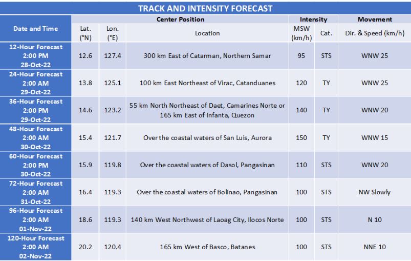
Tropical Storm 'Paeng' will move west northwestward over the Philippine Sea through Sunday while moving towards central or southern portion of Luzon.
On the forecast track, 'Paeng' may make landfall or pass very close to Catanduanes tomorrow morning.
Another landfall scenario is likely on Sunday morning over Aurora or the east coast of Quezon (including Polillo Islands).
Considering the southward shift in the forecast track, a possible landfall in the eastern portion of Bicol Region is not ruled out at this time.
The cyclone is forecast to further intensify while moving over the warm waters of the Philippine Sea. It is forecast to reach typhoon category as it moves very close to Bicol Region. The occurrence of rapid intensification within 48 hours.
HAZARDS AFFECTING LAND AREAS
Heavy Rainfall
Today through tomorrow early morning: Heavy to intense with at times torrential rains possible over Bicol Region, Northern Samar, Samar, and Eastern Samar. Moderate to heavy with at times intense rains over Western Visayas, Marinduque, Romblon, and Quezon.
Light to moderate with at times heavy rains possible over Caraga, Zamboanga Peninsula, BARMM, Northern Mindanao, mainland Cagayan Valley, Aurora, Rizal, Laguna, and the rest of Visayas.
Tomorrow early morning through Sunday morning: Heavy to intense with at times torrential rains possible over CALABARZON, Bicol Region, Aurora, Nueva Vizcaya, Quirino.
Moderate to heavy with at times intense rains over Metro Manila, mainland Cagayan Valley, Cordillera Administrative Region, Western Visayas, Marinduque, Romblon, Mindoro Provinces, and the rest of Central Luzon. Light to moderate with at times heavy rains possible over the rest of Luzon and Visayas.
Under these conditions, flooding and rain-induced landslides are expected, especially in areas that are highly or very highly susceptible to these hazard as identified in hazard maps and in localities with significant antecedent rainfall.
Heavy rain areas may be updated in the succeeding bulletins should there be significant shifts in the track and intensity forecast of 'Paeng'.
Severe Winds
Winds may reach gale-force strength during the passage of PAENG within any of the areas where Tropical Cyclone Wind Signal No. 2 is hoisted. Strong winds may be experienced within any of the areas where Tropical Cyclone Wind Signal (TCWS) No. 1 is hoisted throughout the entire passage of 'Paeng'.
Per latest track and intensity forecast, the highest wind signal that will likely be hoisted is Wind Signal No. 4 in anticipation of typhoon-force conditions associated with the storm.
The surge of the Northeast Monsoon enhanced will also bring strong winds with gusts reaching gale-force strength over Batanes, Babuyan Islands, Ilocos Provinces, the northern and eastern portions of mainland Cagayan, the eastern portions of Isabela, and the northern portion of Apayao.
Coastal Inundation
There is minimal to moderate risk of storm surge of up to 2.0 m in height which may cause flooding in the low-lying and exposed coastal areas of Catanduanes, Albay, Camarines Norte, Polillo Islands and the northern and eastern portions of Camarines Sur.
HAZARDS AFFECTING COASTAL WATERS
Under the influence of the surge of the Northeast Monsoon, a marine gale warning is in effect over the seaboards of Northern Luzon and the eastern seaboards of Central Luzon, Southern Luzon, Visayas, and Mindanao.
TROPICAL CYCLONES
'Paeng' is the Philippines’ 16th tropical cyclone for 2022. It developed into a tropical depression at 8 am on Wednesday, October 26.
On average, there are 20 tropical cyclones that could form or enter the PAR each year. Only half of those are projected to make landfall.
— The Summit Express
 |
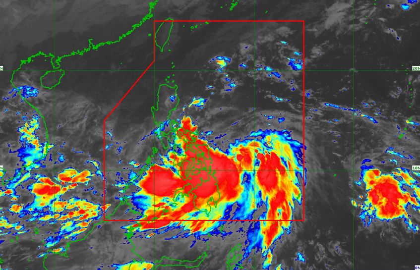
| Satellite image of Tropical Storm 'Paeng' as of 5:20 am, October 28, 2022. PAGASA |
'Bagyong Paeng' has maximum sustained winds of 75 km/h near the center, gustiness of up to 90 km/h and and central pressure of 992 hPa. It is moving westward at 15 km/h.
Strong winds extend outwards up to 480 km from the center.
TROPICAL CYCLONE WIND SIGNALS (TCWS) IN EFFECT
TCWS No. 2
Luzon
- Catanduanes
- Albay
- Sorsogon
- the eastern portion of Camarines Sur (Caramoan, Garchitorena, Presentacion, Lagonoy, Goa, San Jose, Tigaon, Iriga City, Saglay, Buhi)
Visayas
- Northern Samar
- the northern portion of Eastern Samar (Jipapad, Arteche, Oras, San Policarpo, Maslog, Dolores, Can-Avid, Taft)
TCWS No. 1
Luzon
- Masbate including Ticao and Burias Islands
- Camarines Norte
- the rest of Camarines Sur
- Romblon
- Marinduque
- Quezon including Pollilo Islands
- Laguna
- Rizal
Visayas
- Samar
- the rest of Eastern Samar
- Biliran
- Leyte
- Southern Leyte
- the northern portion of Cebu (Daanbantayan, Medellin, San Remigio, Tabogon, City of Bogo, Borbon) including Bantayan and Camotes Islands
Mindanao
- Dinagat Islands
- Surigao del Norte including Siargao and Bucas Grande Islands
- the northern portion of Surigao del Sur (Carrascal, Cantilan, Madrid, Carmen, Lanuza, Cortes, City of Tandag, Bayabas, Tago, Cagwait)
TRACK AND INTENSITY OUTLOOK
Tropical Storm 'Paeng' will move west northwestward over the Philippine Sea through Sunday while moving towards central or southern portion of Luzon.
On the forecast track, 'Paeng' may make landfall or pass very close to Catanduanes tomorrow morning.
Another landfall scenario is likely on Sunday morning over Aurora or the east coast of Quezon (including Polillo Islands).
Considering the southward shift in the forecast track, a possible landfall in the eastern portion of Bicol Region is not ruled out at this time.
The cyclone is forecast to further intensify while moving over the warm waters of the Philippine Sea. It is forecast to reach typhoon category as it moves very close to Bicol Region. The occurrence of rapid intensification within 48 hours.
HAZARDS AFFECTING LAND AREAS
Heavy Rainfall
Today through tomorrow early morning: Heavy to intense with at times torrential rains possible over Bicol Region, Northern Samar, Samar, and Eastern Samar. Moderate to heavy with at times intense rains over Western Visayas, Marinduque, Romblon, and Quezon.
Light to moderate with at times heavy rains possible over Caraga, Zamboanga Peninsula, BARMM, Northern Mindanao, mainland Cagayan Valley, Aurora, Rizal, Laguna, and the rest of Visayas.
Tomorrow early morning through Sunday morning: Heavy to intense with at times torrential rains possible over CALABARZON, Bicol Region, Aurora, Nueva Vizcaya, Quirino.
Moderate to heavy with at times intense rains over Metro Manila, mainland Cagayan Valley, Cordillera Administrative Region, Western Visayas, Marinduque, Romblon, Mindoro Provinces, and the rest of Central Luzon. Light to moderate with at times heavy rains possible over the rest of Luzon and Visayas.
Under these conditions, flooding and rain-induced landslides are expected, especially in areas that are highly or very highly susceptible to these hazard as identified in hazard maps and in localities with significant antecedent rainfall.
Heavy rain areas may be updated in the succeeding bulletins should there be significant shifts in the track and intensity forecast of 'Paeng'.
Severe Winds
Winds may reach gale-force strength during the passage of PAENG within any of the areas where Tropical Cyclone Wind Signal No. 2 is hoisted. Strong winds may be experienced within any of the areas where Tropical Cyclone Wind Signal (TCWS) No. 1 is hoisted throughout the entire passage of 'Paeng'.
Per latest track and intensity forecast, the highest wind signal that will likely be hoisted is Wind Signal No. 4 in anticipation of typhoon-force conditions associated with the storm.
The surge of the Northeast Monsoon enhanced will also bring strong winds with gusts reaching gale-force strength over Batanes, Babuyan Islands, Ilocos Provinces, the northern and eastern portions of mainland Cagayan, the eastern portions of Isabela, and the northern portion of Apayao.
Coastal Inundation
There is minimal to moderate risk of storm surge of up to 2.0 m in height which may cause flooding in the low-lying and exposed coastal areas of Catanduanes, Albay, Camarines Norte, Polillo Islands and the northern and eastern portions of Camarines Sur.
HAZARDS AFFECTING COASTAL WATERS
Under the influence of the surge of the Northeast Monsoon, a marine gale warning is in effect over the seaboards of Northern Luzon and the eastern seaboards of Central Luzon, Southern Luzon, Visayas, and Mindanao.
TROPICAL CYCLONES
'Paeng' is the Philippines’ 16th tropical cyclone for 2022. It developed into a tropical depression at 8 am on Wednesday, October 26.
On average, there are 20 tropical cyclones that could form or enter the PAR each year. Only half of those are projected to make landfall.
— The Summit Express


