MANILA, Philippines – 'Bagyong Paeng' maintain its strength over the Philippine Sea, state weather bureau PAGASA announced in its 5:00 am update on Thursday, October 27, 2022.
SEE ALSO: 'Bagyong Paeng' PAGASA weather update October 28, 2022
SEE ALSO: 'Bagyong Paeng' PAGASA weather update October 28, 2022
At 4:00 am today, the center of the eye of Tropical Depression 'Paeng' was estimated based on all available data at 660 km East of Borongan City, Eastern Samar.
'Bagyong Paeng' has maximum sustained winds of 55 km/h near the center, gustiness of up to 70 km/h, and central pressure of 1000 hPa. It is moving west northwestward at 10 km/h.
Strong winds extend outwards up to 460 km from the center.
TROPICAL CYCLONE WIND SIGNALS (TCWS) IN EFFECT
TCWS No.1
 |
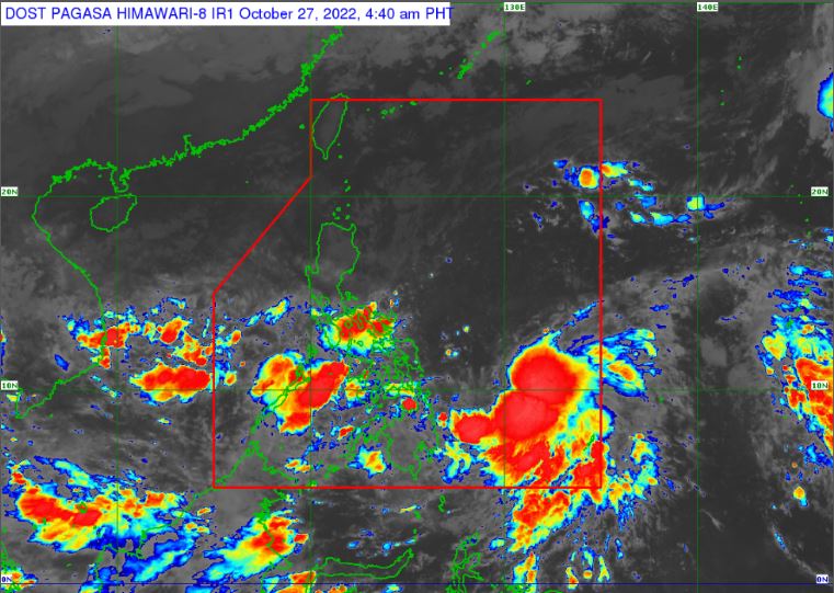
| Satellite image of Tropical Depression 'Paeng' as of 4:40 am, October 27, 2022. PAGASA |
'Bagyong Paeng' has maximum sustained winds of 55 km/h near the center, gustiness of up to 70 km/h, and central pressure of 1000 hPa. It is moving west northwestward at 10 km/h.
Strong winds extend outwards up to 460 km from the center.
TROPICAL CYCLONE WIND SIGNALS (TCWS) IN EFFECT
TCWS No.1
Luzon:
TRACK AND INTENSITY OUTLOOK
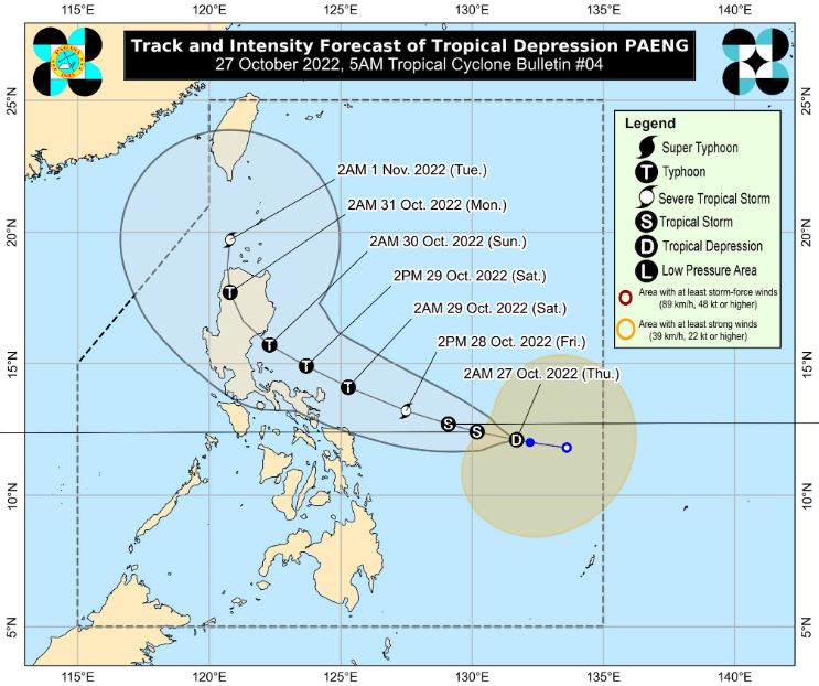
Tropical Depression 'Paeng' is forecast to track generally west northwestward over the Philippine Sea through Sunday while moving towards the northern or central portion of Luzon.
On the forecast track, a landfall scenario is possible on Sunday within any of the coastal areas along the eastern portions of Central Luzon or mainland Cagayan Valley.
Considering recent shifts in the forecast track, a possible southward shift in the possible area of landfall (i.e., towards the eastern portions of Central or Southern Luzon) is not ruled out at this time.
'Paeng' may further intensify while moving over warm waters of the Philippine Sea. It is forecast to reach tropical storm category within 24 hours and may become a typhoon by Saturday. The occurrence of rapid intensification in the next 72 hours is not ruled out.
HAZARDS AFFECTING LAND AREAS
Heavy Rainfall
Tomorrow early morning through evening: Moderate to heavy with at times intense rains likely over Bicol Region, Eastern Visayas.
Light to moderate with at times heavy rains possible over MIMAROPA, BARMM, Zamboanga Peninsula, Northern Mindanao, Caraga, Quezon, Cagayan, Isabela, Apayao, Aurora, and the rest of Visayas.
Tomorrow evening through Saturday: Heavy to torrential rains possible over Bicol Region, Northern Samar, and Quezon. Moderate to heavy with at times intense rains possible over Metro Manila, Western Visayas, Aurora, Bulacan, Mindoro Provinces, Marinduque, Romblon, the eastern portions of Cagayan and Isabela, the rest of Eastern Visayas, and CALABARZON.
Light to moderate with at times heavy rains possible over Cordillera Administrative Region, Zamboanga Peninsula, BARMM, and the rest of Visayas, Cagayan Valley, Central Luzon, and MIMAROPA.
Due to the Shear Line and the trough of 'Paeng', heavy rains are possible over Visayas, most of Southern Luzon, and the northern and western portions of Mindanao.
Severe Winds
Strong winds may be experienced within any of the areas where Tropical Cyclone Wind Signal (TCWS) No. 1 is hoisted throughout the entire passage of the cyclone.
Per latest track and intensity forecast, the highest wind signal that will likely be hoisted is Wind Signal No. 4, in anticipation of typhoon-force conditions associated with 'Paeng'.
In the next 24 hours, the surge of the Northeast Monsoon will also bring strong winds with gusts reaching gale-force strength over Batanes, Babuyan Islands, Quezon, Bicol Region, Marinduque, Romblon, and the northern portions of mainland Cagayan, Apayao, and Ilocos Norte.
HAZARDS AFFECTING COASTAL WATERS
Under the influence of the surge of the Northeast Monsoon, a marine gale warning is in effect over the seaboards of Northern Luzon and the eastern seaboards of Central Luzon, Southern Luzon, and Visayas.
In the next 24 hours, the combined effects of the surge of the Northeast Monsoon and the approaching tropical cyclone may also bring moderate to rough seas (1.5 to 3.5 m) over the eastern seaboard of Mindanao.
These conditions may be risky for those using small seacrafts. Mariners are advised to take precautionary measures when venturing out to sea and, if possible, avoid navigating in these conditions.
TROPICAL CYCLONES
'Paeng' is the Philippines’ 16th tropical cyclone for 2022. It developed into a tropical depression at 8 am on Wednesday, October 26.
On average, there are 20 tropical cyclones that could form or enter the PAR each year. Only half of those are projected to make landfall.
— The Summit Express
- the northern portion of Eastern Samar (San Julian, Sulat, Taft, Can-Avid, Dolores, Maslog, Oras, San Policarpo, Arteche, Jipapad, City of Borongan)
- the eastern portion of Northern Samar (Lapinig, Gamay, Mapanas, Palapag, Laoang, Pambujan, Catubig, Las Navas)
TRACK AND INTENSITY OUTLOOK
Tropical Depression 'Paeng' is forecast to track generally west northwestward over the Philippine Sea through Sunday while moving towards the northern or central portion of Luzon.
On the forecast track, a landfall scenario is possible on Sunday within any of the coastal areas along the eastern portions of Central Luzon or mainland Cagayan Valley.
Considering recent shifts in the forecast track, a possible southward shift in the possible area of landfall (i.e., towards the eastern portions of Central or Southern Luzon) is not ruled out at this time.
'Paeng' may further intensify while moving over warm waters of the Philippine Sea. It is forecast to reach tropical storm category within 24 hours and may become a typhoon by Saturday. The occurrence of rapid intensification in the next 72 hours is not ruled out.
HAZARDS AFFECTING LAND AREAS
Heavy Rainfall
Tomorrow early morning through evening: Moderate to heavy with at times intense rains likely over Bicol Region, Eastern Visayas.
Light to moderate with at times heavy rains possible over MIMAROPA, BARMM, Zamboanga Peninsula, Northern Mindanao, Caraga, Quezon, Cagayan, Isabela, Apayao, Aurora, and the rest of Visayas.
Tomorrow evening through Saturday: Heavy to torrential rains possible over Bicol Region, Northern Samar, and Quezon. Moderate to heavy with at times intense rains possible over Metro Manila, Western Visayas, Aurora, Bulacan, Mindoro Provinces, Marinduque, Romblon, the eastern portions of Cagayan and Isabela, the rest of Eastern Visayas, and CALABARZON.
Light to moderate with at times heavy rains possible over Cordillera Administrative Region, Zamboanga Peninsula, BARMM, and the rest of Visayas, Cagayan Valley, Central Luzon, and MIMAROPA.
Due to the Shear Line and the trough of 'Paeng', heavy rains are possible over Visayas, most of Southern Luzon, and the northern and western portions of Mindanao.
Severe Winds
Strong winds may be experienced within any of the areas where Tropical Cyclone Wind Signal (TCWS) No. 1 is hoisted throughout the entire passage of the cyclone.
Per latest track and intensity forecast, the highest wind signal that will likely be hoisted is Wind Signal No. 4, in anticipation of typhoon-force conditions associated with 'Paeng'.
In the next 24 hours, the surge of the Northeast Monsoon will also bring strong winds with gusts reaching gale-force strength over Batanes, Babuyan Islands, Quezon, Bicol Region, Marinduque, Romblon, and the northern portions of mainland Cagayan, Apayao, and Ilocos Norte.
HAZARDS AFFECTING COASTAL WATERS
Under the influence of the surge of the Northeast Monsoon, a marine gale warning is in effect over the seaboards of Northern Luzon and the eastern seaboards of Central Luzon, Southern Luzon, and Visayas.
In the next 24 hours, the combined effects of the surge of the Northeast Monsoon and the approaching tropical cyclone may also bring moderate to rough seas (1.5 to 3.5 m) over the eastern seaboard of Mindanao.
These conditions may be risky for those using small seacrafts. Mariners are advised to take precautionary measures when venturing out to sea and, if possible, avoid navigating in these conditions.
TROPICAL CYCLONES
'Paeng' is the Philippines’ 16th tropical cyclone for 2022. It developed into a tropical depression at 8 am on Wednesday, October 26.
On average, there are 20 tropical cyclones that could form or enter the PAR each year. Only half of those are projected to make landfall.
— The Summit Express


