MANILA, Philippines – Tropical Depression 'Neneng' continuous to maintain its strength while moving west northwestward, state weather bureau PAGASA announced in its 5:00 am update on Friday, October 14, 2022.
At 4:00 am today, the center of 'Bagyong Neneng' was estimated based on all available data at 1,015 km East of Extreme Northern Luzon.
'Bagyong Neneng' has maximum sustained winds of 55 km/h near the center, gustiness of up to 70 km/h, and central pressure of 1000 hPa. It is moving west northwestward at 10 km/h.
Strong winds extend outwards up to 280 km from the center.
No Tropical Cyclone Wind Signal is currently in effect.
TRACK AND INTENSITY OUTLOOK
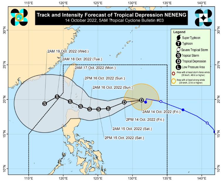
Tropical Depression 'Neneng' is forecast to move west southwestward in the next 24 hours before turning westward tomorrow.
By Sunday, it will begin to track west northwestward towards Extreme Northern Luzon.
On the track forecast, 'Neneng' will make landfall or may pass very close in Babuyan Islands or Batanes.
'Neneng' is forecast to further intensify while moving over the Philippine Sea and may reach tropical storm category by Saturday. The possibility of further intensification prior to its close approach to Extreme Northern Luzon is not ruled out.
HAZARDS AFFECTING LAND AREAS
Heavy Rainfall
The passage of 'Neneng' may bring heavy rains over Northern Luzon beginning tomorrow. Under these conditions, flooding is possible (including flash floods) and rain-induced landslides are possible especially in areas that are highly or very highly susceptible to these hazard as identified in hazard maps.
Severe Winds
Tropical Cyclone Wind Signal No.1 may be hoisted this morning or afternoon over the eastern portion of Northern Luzon in the anticipation of winds of at least strong breeze to near gale strength associated with the approaching tropical cyclone.
Per latest track and intensity forecast, the most likely highest wind signal that will be hoisted is Wind Signal No. 2.
HAZARDS AFFECTING COASTAL WATERS
Due to the surge of northeasterly surface windflow, a marine gale warning remains in effect over the seaboards of Northern Luzon and the western seaboard of Central Luzon.
The surge of northeasterly surface windflow and the approaching tropical cyclone may also bring moderate to rough seas (1.5 to 3.5 m) over the eastern seaboards of Central and Southern Luzon.
These conditions may be risky for those using small seacrafts. Mariners are advised to take precautionary measures when venturing out to sea and, if possible, avoid navigating in these conditions.
TROPICAL CYCLONES
'Neneng' is the Philippines’ 14th tropical cyclone for 2022. It entered the Philippine Area of Responsibility (PAR) at 12 pm on Thursday, October 13.
On average, there are 20 tropical cyclones that could form or enter the PAR each year. Only half of those are projected to make landfall.
— The Summit Express
At 4:00 am today, the center of 'Bagyong Neneng' was estimated based on all available data at 1,015 km East of Extreme Northern Luzon.
 |
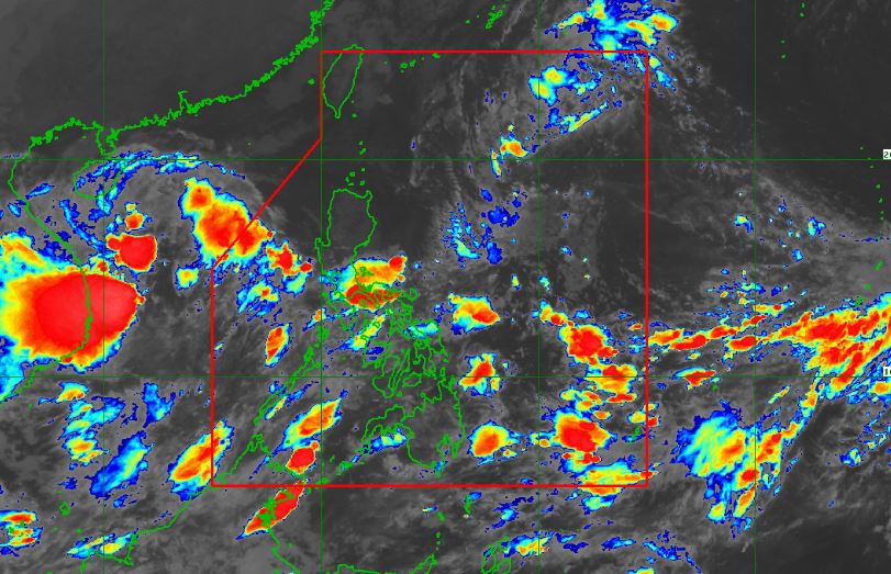
| Satellite image of Tropical Depression 'Neneng' as of 4:30 am, October 14, 2022. PAGASA |
'Bagyong Neneng' has maximum sustained winds of 55 km/h near the center, gustiness of up to 70 km/h, and central pressure of 1000 hPa. It is moving west northwestward at 10 km/h.
Strong winds extend outwards up to 280 km from the center.
No Tropical Cyclone Wind Signal is currently in effect.
TRACK AND INTENSITY OUTLOOK
Tropical Depression 'Neneng' is forecast to move west southwestward in the next 24 hours before turning westward tomorrow.
By Sunday, it will begin to track west northwestward towards Extreme Northern Luzon.
On the track forecast, 'Neneng' will make landfall or may pass very close in Babuyan Islands or Batanes.
'Neneng' is forecast to further intensify while moving over the Philippine Sea and may reach tropical storm category by Saturday. The possibility of further intensification prior to its close approach to Extreme Northern Luzon is not ruled out.
HAZARDS AFFECTING LAND AREAS
Heavy Rainfall
The passage of 'Neneng' may bring heavy rains over Northern Luzon beginning tomorrow. Under these conditions, flooding is possible (including flash floods) and rain-induced landslides are possible especially in areas that are highly or very highly susceptible to these hazard as identified in hazard maps.
Severe Winds
Tropical Cyclone Wind Signal No.1 may be hoisted this morning or afternoon over the eastern portion of Northern Luzon in the anticipation of winds of at least strong breeze to near gale strength associated with the approaching tropical cyclone.
Per latest track and intensity forecast, the most likely highest wind signal that will be hoisted is Wind Signal No. 2.
HAZARDS AFFECTING COASTAL WATERS
Due to the surge of northeasterly surface windflow, a marine gale warning remains in effect over the seaboards of Northern Luzon and the western seaboard of Central Luzon.
The surge of northeasterly surface windflow and the approaching tropical cyclone may also bring moderate to rough seas (1.5 to 3.5 m) over the eastern seaboards of Central and Southern Luzon.
These conditions may be risky for those using small seacrafts. Mariners are advised to take precautionary measures when venturing out to sea and, if possible, avoid navigating in these conditions.
TROPICAL CYCLONES
'Neneng' is the Philippines’ 14th tropical cyclone for 2022. It entered the Philippine Area of Responsibility (PAR) at 12 pm on Thursday, October 13.
On average, there are 20 tropical cyclones that could form or enter the PAR each year. Only half of those are projected to make landfall.
— The Summit Express

