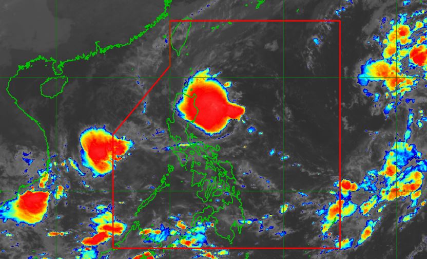
MANILA, Philippines – Tropical Depression 'Maymay' continous to slowly move southwestward over the Philippine Sea, state weather bureau PAGASA announced in its 5:00 am update on Wednesday, October 12, 2022.
At 4:00 am today, the center of 'Bagyong Maymay' was estimated based on all available data 305 km East of Baler, Aurora.
'Bagyong Maymay' has maximum sustained winds of 45 km/h near the center, gustiness of up to 55 km/h, and central pressure of 1002 hPa.
SEE ALSO: 'Bagyong Neneng' PAGASA weather update October 14, 2022
At 4:00 am today, the center of 'Bagyong Maymay' was estimated based on all available data 305 km East of Baler, Aurora.
 |
| Satellite image of Tropical Depression 'Maymay' as of 4:30 am, October 12, 2022. PAGASA |
'Bagyong Maymay' has maximum sustained winds of 45 km/h near the center, gustiness of up to 55 km/h, and central pressure of 1002 hPa.
SEE ALSO: 'Bagyong Neneng' PAGASA weather update October 14, 2022
Strong winds extend outwards up to 200 km from the center.
TROPICAL CYCLONE WIND SIGNALS (TCWS) IN EFFECT
TCWS No.1
Luzon:
TRACK AND INTENSITY OUTLOOK
On the forecast track, the center of Tropical Depression 'Maymay' is forecast to move slowly westward or remain almost stationary in the next 12 hours before it slightly accelerates and move westward towards the eastern coast of Central Luzon.
'Maymay' is forecast to weaken into a low pressure area as it approaches the landmass.
HAZARDS AFFECTING LAND AREAS
Heavy Rains
Today, moderate to heavy with at times intense rains over Cagayan and Isabela. Light to moderate with at times heavy rains over Aurora.
Under these conditions, scattered to widespread flooding (including flash floods) and rain-induced landslides are expected especially in areas that are highly or very highly susceptible to these hazard as identified in hazard maps, and in localities with significant antecedent rainfall.
Severe Winds
Strong winds (strong breeze to near gale strength) may be experienced within any of the areas where Wind Signal No. 1 is currently in effect.
In the next 24 hours, occasional gusts reaching strong to gale-force strength associated with the enhanced northeasterly surface windflow and its convergence with the tropical depression circulation may also be experienced (especially in the coastal and mountainous areas) over Batanes, Cagayan including Babuyan Islands, Cordillera Administrative Region, and Ilocos Region.
HAZARDS AFFECTING COASTAL WATERS
Under the influence of 'Maymay' and the surge of northeasterly surface windflow, a marine gale warning remains in effect over the seaboards of Northern and Central Luzon and the eastern seaboard of Southern Luzon.
In the next 24 hours, the surge of northeasterly surface windflow may also bring moderate to rough seas (1.5 to 3.5 m) over the western seaboards of Central and Southern Luzon.
These conditions may be risky for those using small seacrafts. Mariners are advised to take precautionary measures when venturing out to sea and, if possible, avoid navigating in these conditions.
TROPICAL CYCLONES
'Maymay' is the Philippines’ 13th tropical cyclone for 2022. It developed into tropical depression on Tuesday, October 11.
On average, there are 20 tropical cyclones that could form or enter the Philippine Area of Responsibility each year. Only half of those are projected to make landfall.
— The Summit Express
TROPICAL CYCLONE WIND SIGNALS (TCWS) IN EFFECT
TCWS No.1
Luzon:
- Isabela
- Quirino
- Nueva Vizcaya
- Aurora
- Nueva Ecija
- the extreme northern portion of Quezon (General Nakar, Infanta) including Pollilo Islands
TRACK AND INTENSITY OUTLOOK
On the forecast track, the center of Tropical Depression 'Maymay' is forecast to move slowly westward or remain almost stationary in the next 12 hours before it slightly accelerates and move westward towards the eastern coast of Central Luzon.
'Maymay' is forecast to weaken into a low pressure area as it approaches the landmass.
HAZARDS AFFECTING LAND AREAS
Heavy Rains
Today, moderate to heavy with at times intense rains over Cagayan and Isabela. Light to moderate with at times heavy rains over Aurora.
Under these conditions, scattered to widespread flooding (including flash floods) and rain-induced landslides are expected especially in areas that are highly or very highly susceptible to these hazard as identified in hazard maps, and in localities with significant antecedent rainfall.
Severe Winds
Strong winds (strong breeze to near gale strength) may be experienced within any of the areas where Wind Signal No. 1 is currently in effect.
In the next 24 hours, occasional gusts reaching strong to gale-force strength associated with the enhanced northeasterly surface windflow and its convergence with the tropical depression circulation may also be experienced (especially in the coastal and mountainous areas) over Batanes, Cagayan including Babuyan Islands, Cordillera Administrative Region, and Ilocos Region.
HAZARDS AFFECTING COASTAL WATERS
Under the influence of 'Maymay' and the surge of northeasterly surface windflow, a marine gale warning remains in effect over the seaboards of Northern and Central Luzon and the eastern seaboard of Southern Luzon.
In the next 24 hours, the surge of northeasterly surface windflow may also bring moderate to rough seas (1.5 to 3.5 m) over the western seaboards of Central and Southern Luzon.
These conditions may be risky for those using small seacrafts. Mariners are advised to take precautionary measures when venturing out to sea and, if possible, avoid navigating in these conditions.
TROPICAL CYCLONES
'Maymay' is the Philippines’ 13th tropical cyclone for 2022. It developed into tropical depression on Tuesday, October 11.
On average, there are 20 tropical cyclones that could form or enter the Philippine Area of Responsibility each year. Only half of those are projected to make landfall.
— The Summit Express

