MANILA, Philippines – 'Bagyong Karding' (international name: Noru) maintains strength as it moves further away from Luzon, state weather bureau PAGASA announced in its 8:00 am update on Monday, September 26, 2022.
At 7:00 am today, Typhoon 'Karding' was estimated based on all available data at 190 km West of Dagupan City, Pangasinan.
'Karding' has maximum sustained winds of 140 km/h near the center, gustiness of up to 170 km/h and central pressure of 970 hPa. It is moving west northwestward at 30 km/h.
PAGASA added that strong to typhoon-force winds extend outwards up to 270 km from the center.
TROPICAL CYCLONE WIND SIGNALS (TCWS) IN EFFECT
TCWS No. 2
LUZON:
TCWS No. 1
LUZON:
Tropical Cyclone Wind Signals in other areas are hereby lifted.
TRACK AND INTENSITY OUTLOOK
'Karding' is forecast to continue tracking generally westward over the West Philippine Sea towards Vietnam.
On the track forecast, it will exit the Philippine Area of Responsibility (PAR) tonight.
It is still forecast to slightly weaken or maintain its strength in the near term as it begins to move away from the landmass of Luzon.
A period of re-intensification may occur beginning tonight or tomorrow early morning as the typhoon moves over the West Philippine Sea.
HAZARDS AFFECTING LAND AREAS
Heavy Rainfall
Until noon today: Moderate to heavy with at times intense rains over Zambales, Bataan, and Lubang Islands. Light to moderate with at times heavy rains over the western portion of Pangasinan.
Under these conditions, scattered flooding and rain-induced landslides are still possible, especially in areas that are highly or very highly susceptible to these hazard as identified in hazard maps and in localities with significant antecedent rainfall.
Occasional to monsoon rains are still possible in the next 24 hours over the western sections of Central Luzon, Southern Luzon, and Visayas, especially as the rainbands of 'Karding' moves further away from the landmass.
Severe Winds
Gale-force conditions remain possible within any of the areas where Wind Signal no. 2 is hoisted, while strong winds (strong breeze to near gale strength) may still be experienced within any of the areas where Wind Signal No. 1 is currently in effect.
Rapid de-escalation of wind signals will continue as 'Karding' moves further away from the landmass of Luzon.
HAZARDS AFFECTING COASTAL WATERS
Under the influence of 'Karding', a Marine Gale Warning remains in effect over the western seaboards of Northern and Central Luzon.
In the next 24 hours, the enhanced Southwest Monsoon may also bring moderate to rough seas (1.5 to 3.0 m) over the western seaboards of Southern Luzon, Visayas, and Mindanao.
TROPICAL CYCLONES
'Karding' is the Philippines’ 11th tropical cyclone for 2022. It developed into tropical depression on Thursday, September 22 east of Central Luzon and became super typhoon after a period of explosive intensification on Sunday, September 25.
On average, there are 20 tropical cyclones that could form or enter the Philippine Area of Responsibility each year. Only half of those are projected to make landfall.
— The Summit Express
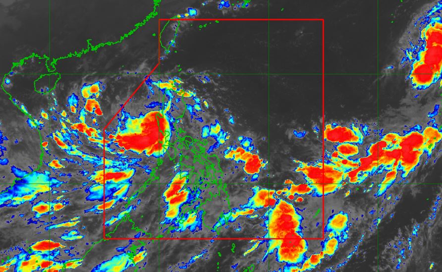
At 7:00 am today, Typhoon 'Karding' was estimated based on all available data at 190 km West of Dagupan City, Pangasinan.
 |
| Satellite image of Typhoon 'Karding' as of 4:30 am, September 26, 2022. PAGASA |
'Karding' has maximum sustained winds of 140 km/h near the center, gustiness of up to 170 km/h and central pressure of 970 hPa. It is moving west northwestward at 30 km/h.
PAGASA added that strong to typhoon-force winds extend outwards up to 270 km from the center.
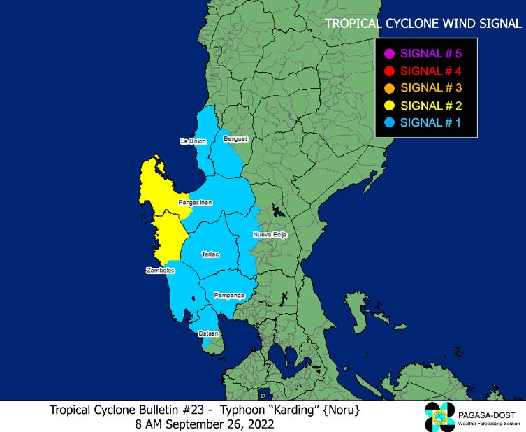
TROPICAL CYCLONE WIND SIGNALS (TCWS) IN EFFECT
TCWS No. 2
LUZON:
- the western section of Pangasinan (Bolinao, Bani, City of Alaminos, Anda, Sual, Labrador, Mabini, Agno, Burgos, Dasol, Infanta, Bugallon, Lingayen, Aguilar)
- the northern portion of Zambales (Santa Cruz, Candelaria, Masinloc, Palauig, Iba)
TCWS No. 1
LUZON:
- La Union
- the rest of Pangasinan
- the southern portion of Benguet (Sablan, La Trinidad, Itogon, Baguio City, Tuba, Kapangan, Tublay)
- the rest of Zambales
- the northern portion of Bataan (Bagac, City of Balanga, Abucay, Samal, Morong, Orani, Hermosa, Dinalupihan)
- Tarlac
- Pampanga
- the western portion of Nueva Ecija (Cabiao, San Isidro, Jaen, San Antonio, Lupao, Science City of Muñoz, Santo Domingo, Talavera, Aliaga, Zaragoza, Cuyapo, Talugtug, Nampicuan, Guimba, Licab, Quezon)
Tropical Cyclone Wind Signals in other areas are hereby lifted.
TRACK AND INTENSITY OUTLOOK
'Karding' is forecast to continue tracking generally westward over the West Philippine Sea towards Vietnam.
On the track forecast, it will exit the Philippine Area of Responsibility (PAR) tonight.
It is still forecast to slightly weaken or maintain its strength in the near term as it begins to move away from the landmass of Luzon.
A period of re-intensification may occur beginning tonight or tomorrow early morning as the typhoon moves over the West Philippine Sea.
HAZARDS AFFECTING LAND AREAS
Heavy Rainfall
Until noon today: Moderate to heavy with at times intense rains over Zambales, Bataan, and Lubang Islands. Light to moderate with at times heavy rains over the western portion of Pangasinan.
Under these conditions, scattered flooding and rain-induced landslides are still possible, especially in areas that are highly or very highly susceptible to these hazard as identified in hazard maps and in localities with significant antecedent rainfall.
Occasional to monsoon rains are still possible in the next 24 hours over the western sections of Central Luzon, Southern Luzon, and Visayas, especially as the rainbands of 'Karding' moves further away from the landmass.
Severe Winds
Gale-force conditions remain possible within any of the areas where Wind Signal no. 2 is hoisted, while strong winds (strong breeze to near gale strength) may still be experienced within any of the areas where Wind Signal No. 1 is currently in effect.
Rapid de-escalation of wind signals will continue as 'Karding' moves further away from the landmass of Luzon.
HAZARDS AFFECTING COASTAL WATERS
Under the influence of 'Karding', a Marine Gale Warning remains in effect over the western seaboards of Northern and Central Luzon.
In the next 24 hours, the enhanced Southwest Monsoon may also bring moderate to rough seas (1.5 to 3.0 m) over the western seaboards of Southern Luzon, Visayas, and Mindanao.
TROPICAL CYCLONES
'Karding' is the Philippines’ 11th tropical cyclone for 2022. It developed into tropical depression on Thursday, September 22 east of Central Luzon and became super typhoon after a period of explosive intensification on Sunday, September 25.
On average, there are 20 tropical cyclones that could form or enter the Philippine Area of Responsibility each year. Only half of those are projected to make landfall.
— The Summit Express

