MANILA, Philippines – 'Bagyong Agaton' intensifies into a tropical storm while moving west northwestward over the coastal waters of Guiuan, Eastern Samar, state weather bureau PAGASA announced in its 5:00 am update on Sunday, April 10, 2022.
At 4:00 am today, the center of 'Bagyong Agaton' was estimated based on all available data including those from Guiuan Doppler Weather Radar over the coastal waters of Guiuan, Eastern Samar.
SEE ALSO: 'Bagyong Agaton' PAGASA weather update April 11, 2022
 |
| Satellite image of 'Bagyong Agaton' as of 5:00 am, April 10, 2022. Photo courtesy of DOST-PAGASA |
At 4:00 am today, the center of 'Bagyong Agaton' was estimated based on all available data including those from Guiuan Doppler Weather Radar over the coastal waters of Guiuan, Eastern Samar.
SEE ALSO: 'Bagyong Agaton' PAGASA weather update April 11, 2022
Tropical Storm 'Agaton' has maximum sustained winds of 65 km/h near the center, gustiness of up to 80 km/h, and central pressure of 998 hPa.
It is moving West northwestward at 10 km/h. Strong winds or higher extend outwards up to 220 km from the center.
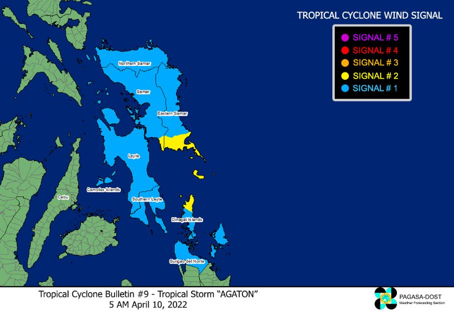
TROPICAL CYCLONE WIND SIGNALS (TCWS)
TCWS No. 2 (Gale-force winds prevailing or expected within the next 24 hours)
Visayas
Mindanao
TCWS No. 1
Visayas
Mindanao
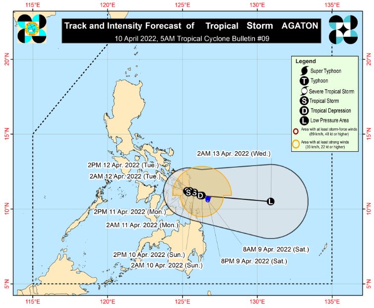
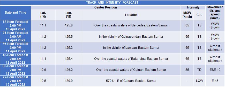
TRACK AND INTENSITY OUTLOOK
Today through late Monday or early Tuesday, 'Agaton' is forecast to remain almost stationary or move west northwestward slowly as it meanders over the southern portion of Eastern Samar and its coastal waters.
Considering its erratic movement, there is an increasing likelihood of landfall over the southern portion of Eastern Samar in the next several hours. A gradually accelerating turn eastward is expected by mid-Tuesday as it interacts with the incoming tropical cyclone with international name 'Malakas'.
'Agaton' is will likely remain a tropical storm for most of the forecast period, although the possibility of being downgraded into a tropical depression is not ruled out due to potential impact of land interaction on the tropical storm.
'Agaton' is forecast to degenerate into a remnant low as 'Malakas' begins to assimilate its circulation by late Tuesday or early Wednesday.
HAZARDS AFFECTING LAND AREAS
Heavy Rainfall
Today: Heavy to intense with at times torrential rains over Eastern Visayas and Dinagat Islands. Moderate to heavy with at times intense rains over the Surigao del Norte, Agusan del Norte, Bohol, and the northern and central portions of Cebu including Bantayan and Camotes Islands. Light to moderate with at times heavy rains over Masbate, Sorsogon, northern Mindanao, and the rest of Visayas and Caraga.
Tomorrow: Moderate to heavy with at times intense rains over Eastern Visayas, Dinagat Islands, Surigao del Norte, and the northern portion of Cebu including Bantayan and Camotes Islands. Light to moderate with at times heavy rains over Masbate, Sorsogon, and the rest of Visayas and Caraga.
Under these conditions and considering significant antecedent rainfall, scattered to widespread flooding (including flooding) and rain-induced landslides are expected especially in areas that are highly or very highly susceptible to these hazard as identified in hazard maps.
Severe Winds
Winds may reach gale-force in strength in any of the areas where Wind Signal No. 2 is hoisted throughout the passage of Tropical Storm 'Agaton'.
Strong winds (strong breeze to near gale conditions) will be experienced within any of the areas where Wind Signal No. 1 is currently in effect.
HAZARDS AFFECTING COASTAL WATERS
In the next 24 hours, rough to very rough seas (2.8 to 5.0 m) will prevail over the seaboards of areas where Wind Signals No. 2 and 1 are hoisted. These conditions may be risky for most seacrafts. Mariners of small seacrafts are advised to remain in port or take shelter, while those operating larger vessels are advised to take precautionary measures when venturing out to sea and, if possible, avoid navigating in these conditions.
In the next 24 hours, moderate to rough seas (1.2 to 3.4 m) will also prevail over the remaining seaboards of the country that are not under any wind signal or gale warning. These conditions may be risky for those using small seacrafts. Mariners are advised to take precautionary measures when venturing out to sea and, if possible, avoid navigating in these conditions.
TROPICAL CYCLONES
'Agaton' is the country's first tropical cyclone for 2022, developed into a tropical depression on April 9.
On average, there are 20 tropical cyclones that could form or enter the Philippine Area of Responsibility each year. Only half of those are projected to make landfall.
— The Summit Express
It is moving West northwestward at 10 km/h. Strong winds or higher extend outwards up to 220 km from the center.
TROPICAL CYCLONE WIND SIGNALS (TCWS)
TCWS No. 2 (Gale-force winds prevailing or expected within the next 24 hours)
Visayas
- the southern portion of Eastern Samar (Guiuan, Mercedes, Salcedo, Quinapondan, Giporlos, Balangiga, Lawaan, General Macarthur, Hernani, Llorente)
- the extreme southern portion of Samar (Marabut)
Mindanao
- the northern portion of Dinagat Islands (Loreto, Tubajon)
TCWS No. 1
Visayas
- the rest of Eastern Samar
- the rest of Samar
- Northern Samar
- Biliran
- Leyte
- Southern Leyte
- Camotes Islands
Mindanao
- Surigao del Norte
- the rest of Dinagat Islands
TRACK AND INTENSITY OUTLOOK
Today through late Monday or early Tuesday, 'Agaton' is forecast to remain almost stationary or move west northwestward slowly as it meanders over the southern portion of Eastern Samar and its coastal waters.
Considering its erratic movement, there is an increasing likelihood of landfall over the southern portion of Eastern Samar in the next several hours. A gradually accelerating turn eastward is expected by mid-Tuesday as it interacts with the incoming tropical cyclone with international name 'Malakas'.
'Agaton' is will likely remain a tropical storm for most of the forecast period, although the possibility of being downgraded into a tropical depression is not ruled out due to potential impact of land interaction on the tropical storm.
'Agaton' is forecast to degenerate into a remnant low as 'Malakas' begins to assimilate its circulation by late Tuesday or early Wednesday.
HAZARDS AFFECTING LAND AREAS
Heavy Rainfall
Today: Heavy to intense with at times torrential rains over Eastern Visayas and Dinagat Islands. Moderate to heavy with at times intense rains over the Surigao del Norte, Agusan del Norte, Bohol, and the northern and central portions of Cebu including Bantayan and Camotes Islands. Light to moderate with at times heavy rains over Masbate, Sorsogon, northern Mindanao, and the rest of Visayas and Caraga.
Tomorrow: Moderate to heavy with at times intense rains over Eastern Visayas, Dinagat Islands, Surigao del Norte, and the northern portion of Cebu including Bantayan and Camotes Islands. Light to moderate with at times heavy rains over Masbate, Sorsogon, and the rest of Visayas and Caraga.
Under these conditions and considering significant antecedent rainfall, scattered to widespread flooding (including flooding) and rain-induced landslides are expected especially in areas that are highly or very highly susceptible to these hazard as identified in hazard maps.
Severe Winds
Winds may reach gale-force in strength in any of the areas where Wind Signal No. 2 is hoisted throughout the passage of Tropical Storm 'Agaton'.
Strong winds (strong breeze to near gale conditions) will be experienced within any of the areas where Wind Signal No. 1 is currently in effect.
HAZARDS AFFECTING COASTAL WATERS
In the next 24 hours, rough to very rough seas (2.8 to 5.0 m) will prevail over the seaboards of areas where Wind Signals No. 2 and 1 are hoisted. These conditions may be risky for most seacrafts. Mariners of small seacrafts are advised to remain in port or take shelter, while those operating larger vessels are advised to take precautionary measures when venturing out to sea and, if possible, avoid navigating in these conditions.
In the next 24 hours, moderate to rough seas (1.2 to 3.4 m) will also prevail over the remaining seaboards of the country that are not under any wind signal or gale warning. These conditions may be risky for those using small seacrafts. Mariners are advised to take precautionary measures when venturing out to sea and, if possible, avoid navigating in these conditions.
TROPICAL CYCLONES
'Agaton' is the country's first tropical cyclone for 2022, developed into a tropical depression on April 9.
On average, there are 20 tropical cyclones that could form or enter the Philippine Area of Responsibility each year. Only half of those are projected to make landfall.
— The Summit Express


