MANILA, Philippines – 'Bagyong Maring' (international name: Kompasu) continues to assimilate the remnant low pressure area of 'Nando', state weather bureau PAGASA announced in its 5:00 am update on Sunday, October 10, 2021.
SEE ALSO: 'Bagyong Maring' PAGASA weather update October 11, 2021
SEE ALSO: 'Bagyong Maring' PAGASA weather update October 11, 2021
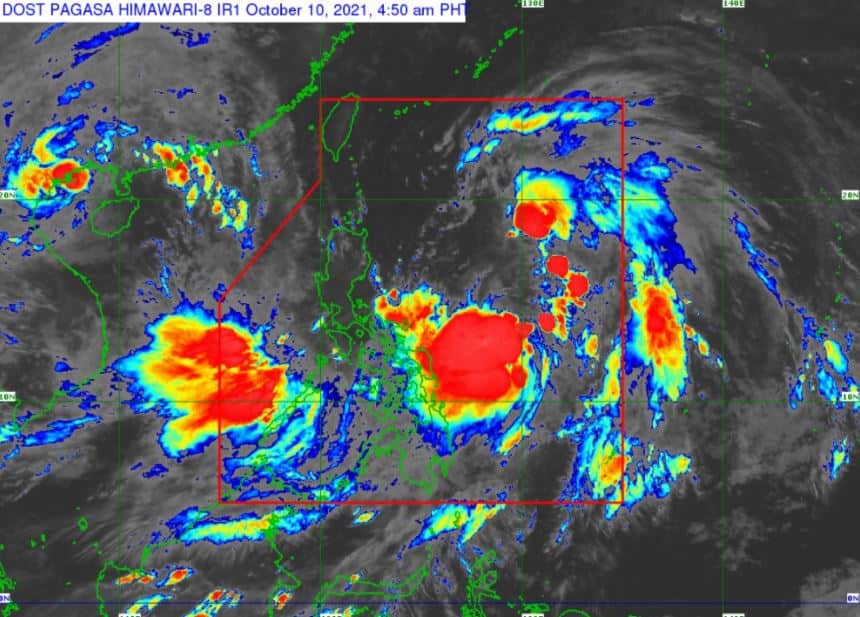
At 4:00 am today, the center of Tropical Storm 'Maring' was estimated based on all available data 665 km East of Virac, Catanduanes.
'Bagyong Maring' has maximum sustained winds of 85 km/h near the center, gustiness of up to 105 km/h, and central pressure of 992 hPa. It is moving northward at 10 km/h. Strong winds or higher extend outwards up to 750 km from the center.
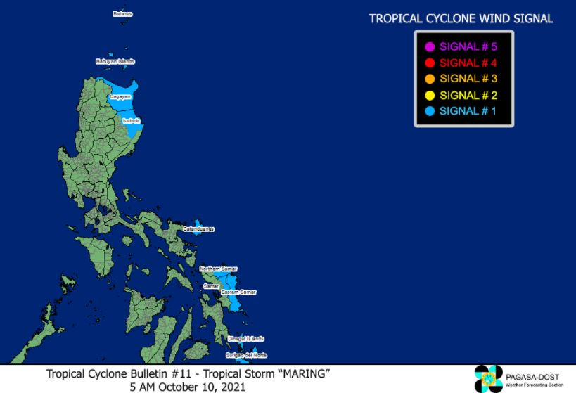
TROPICAL CYCLONE WIND SIGNALS IN EFFECT
TCWS No.1 (Strong winds prevailing or expected within 36 hours)
Luzon
Visayas
Mindanao
TRACK AND INTENSITY OUTLOOK
The merger event between Tropical Storm 'Maring' and the remnant low pressure area of 'Nando' will likely be completed in the next 6 to 12 hours.
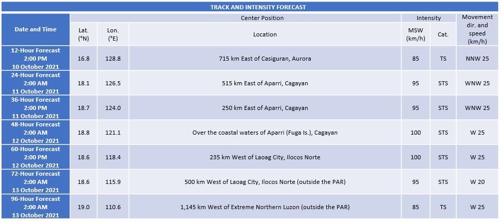
Afterwards, the merger cyclone is forecast to gradually intensify within the forecast period. It may be upgraded to severe tropical storm category within the next 24 to 36 hours.
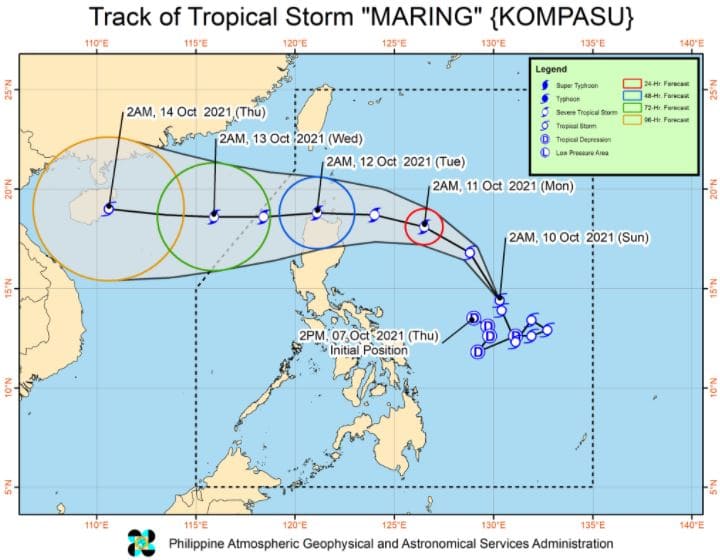
In the next 12 hours, the tropical storm is forecast to accelerate and move north northwestward over the Philippine Sea, notwithstanding the possibility of short-term erratic motion as it assimilates the circulation of 'Nando'.
Afterwards, the storm will turn and move west northwestward towards Extreme Northern Luzon.
On the forecast track, 'Maring' is forecast to move over the Luzon Strait and pass close or over the Babuyan Islands between tomorrow evening and Tuesday morning.
However, the possibility of a landfall over mainland Luzon is not ruled out at this time.
Afterwards, the storm is forecast to move generally westward over the West Philippine Sea beginning Tuesday through the remainder of the forecast period.
HAZARDS AFFECTING LAND AREAS
Heavy Rainfall
The gradual enhancement of the southwesterlies may bring rains over Western Visayas, Palawan, and Occidental Mindoro.
In the next 24 hours, moderate to heavy rains due to the tropical storm are possible over Eastern Samar and Catanduanes.
Furthermore, light to moderate with at times heavy rains are also possible over Bicol Region, Caraga Region, and the rest of Visayas. Under these conditions, isolated to scattered flash floods and rain-induced landslides are possible especially in areas that are highly or very highly susceptible to these hazard as identified in hazard maps.
Severe Winds
Strong winds (strong breeze to near gale conditions) with higher gusts are prevailing in areas where TCWS No. 1 is currently in effect. This may generally bring up to very light damage to structures and vegetation.
Due to the expansive wind field of the tropical storm and the gradual enhancement of the southwesterlies and northeasterlies, occasionally gusts reaching strong breeze to near gale in strength are possible in the next 24 hours over the coastal and upland/mountain areas of Extreme Northern Luzon, MIMAROPA, Bicol Region, Visayas, Caraga Region, and Northern Mindanao that are not under TCWS.
HAZARDS AFFECTING COASTAL WATERS
Under the influence of Tropical Storm 'Maring' and the northeasterly wind flow, a Gale Warning is in effect for eastern seaboards of the country.
In the next 24 hours, moderate to rough seas will prevail the remaining seaboards of Luzon and Visayas, and the northern seaboard of Mindanao. These conditions are risky for those using small seacrafts. Mariners are advised to take precautionary measures when venturing out to sea and, if possible, avoid navigating in these conditions.
TROPICAL CYCLONES
'Maring' and 'Nando' are the 13th and 14th tropical cyclone this year. 'Maring' developed into a tropical depression while east of Bicol region on Thursday afternoon, October 7.
PAGASA predicts that 2–3 tropical cyclones may enter/develop in the Philippine Area of Responsibility (PAR) this month. On October 4, tropical depression 'Lannie' developed while east of Surigao del Norte and made 10 landfalls across northern Mindanao, the Visayas, and Palawan.
On average, there are 20 tropical cyclones that could form or enter the PAR each year. Only half of those are projected to make landfall.
The weather agency declared the onset of the rainy season on Friday, June 5.
— The Summit Express
 |
| Satellite image of Bagyong 'Maring' as of 4:50 am, October 10, 2021. Photo from PAGASA |
'Bagyong Maring' has maximum sustained winds of 85 km/h near the center, gustiness of up to 105 km/h, and central pressure of 992 hPa. It is moving northward at 10 km/h. Strong winds or higher extend outwards up to 750 km from the center.
TROPICAL CYCLONE WIND SIGNALS IN EFFECT
TCWS No.1 (Strong winds prevailing or expected within 36 hours)
Luzon
- Catanduanes
- Batanes
- Cagayan including Babuyan Islands
- the northeastern portion of Isabela (Santa Maria, Cabagan, Tumauini, San Pablo, Maconacon, Divilacan, Palanan, Ilagan City, San Mariano)
Visayas
- Eastern Samar
- the eastern portion of Northern Samar (San Roque, Pambujan, Las Navas, Catubig, Laoang, Mapanas, Lapinig, Gamay, Palapag, Mondragon, Silvino Lobos)
- the eastern portion of Samar (Matuguinao, San Jose de Buan, Hinabangan, Paranas)
Mindanao
- Dinagat Islands
- Surigao del Norte
TRACK AND INTENSITY OUTLOOK
The merger event between Tropical Storm 'Maring' and the remnant low pressure area of 'Nando' will likely be completed in the next 6 to 12 hours.
Afterwards, the merger cyclone is forecast to gradually intensify within the forecast period. It may be upgraded to severe tropical storm category within the next 24 to 36 hours.
In the next 12 hours, the tropical storm is forecast to accelerate and move north northwestward over the Philippine Sea, notwithstanding the possibility of short-term erratic motion as it assimilates the circulation of 'Nando'.
Afterwards, the storm will turn and move west northwestward towards Extreme Northern Luzon.
On the forecast track, 'Maring' is forecast to move over the Luzon Strait and pass close or over the Babuyan Islands between tomorrow evening and Tuesday morning.
However, the possibility of a landfall over mainland Luzon is not ruled out at this time.
Afterwards, the storm is forecast to move generally westward over the West Philippine Sea beginning Tuesday through the remainder of the forecast period.
HAZARDS AFFECTING LAND AREAS
Heavy Rainfall
The gradual enhancement of the southwesterlies may bring rains over Western Visayas, Palawan, and Occidental Mindoro.
In the next 24 hours, moderate to heavy rains due to the tropical storm are possible over Eastern Samar and Catanduanes.
Furthermore, light to moderate with at times heavy rains are also possible over Bicol Region, Caraga Region, and the rest of Visayas. Under these conditions, isolated to scattered flash floods and rain-induced landslides are possible especially in areas that are highly or very highly susceptible to these hazard as identified in hazard maps.
Severe Winds
Strong winds (strong breeze to near gale conditions) with higher gusts are prevailing in areas where TCWS No. 1 is currently in effect. This may generally bring up to very light damage to structures and vegetation.
Due to the expansive wind field of the tropical storm and the gradual enhancement of the southwesterlies and northeasterlies, occasionally gusts reaching strong breeze to near gale in strength are possible in the next 24 hours over the coastal and upland/mountain areas of Extreme Northern Luzon, MIMAROPA, Bicol Region, Visayas, Caraga Region, and Northern Mindanao that are not under TCWS.
HAZARDS AFFECTING COASTAL WATERS
Under the influence of Tropical Storm 'Maring' and the northeasterly wind flow, a Gale Warning is in effect for eastern seaboards of the country.
In the next 24 hours, moderate to rough seas will prevail the remaining seaboards of Luzon and Visayas, and the northern seaboard of Mindanao. These conditions are risky for those using small seacrafts. Mariners are advised to take precautionary measures when venturing out to sea and, if possible, avoid navigating in these conditions.
TROPICAL CYCLONES
'Maring' and 'Nando' are the 13th and 14th tropical cyclone this year. 'Maring' developed into a tropical depression while east of Bicol region on Thursday afternoon, October 7.
PAGASA predicts that 2–3 tropical cyclones may enter/develop in the Philippine Area of Responsibility (PAR) this month. On October 4, tropical depression 'Lannie' developed while east of Surigao del Norte and made 10 landfalls across northern Mindanao, the Visayas, and Palawan.
On average, there are 20 tropical cyclones that could form or enter the PAR each year. Only half of those are projected to make landfall.
The weather agency declared the onset of the rainy season on Friday, June 5.
— The Summit Express


