MANILA, Philippines – 'Bagyong Maring' (international name: Kompasu) intensifies further and remains a large tropical cyclone, state weather bureau PAGASA announced in its 5:00 am update on Saturday, October 9, 2021.
At 4:00 am today, the center of Tropical Storm 'Maring' was estimated based on all available data at 875 km East of Catarman, Northern Samar.
SEE ALSO: 'Bagyong Maring' PAGASA weather update October 10, 2021
At 4:00 am today, the center of Tropical Storm 'Maring' was estimated based on all available data at 875 km East of Catarman, Northern Samar.
SEE ALSO: 'Bagyong Maring' PAGASA weather update October 10, 2021
'Bagyong Maring' has maximum sustained winds of 85 km/h near the center, gustiness of up to 105 km/h, and central pressure of 992 hPa. It is moving east northeastward at 15 km/h. Strong winds or higher extend outwards up to 600 km from the center.
No Tropical Cyclone Wind Signal is currently in effect.
Meanwhile, another tropical depression entered the Philippine area of responsibility (PAR) on Friday and was named Nando. At 4:00 am today, it was last located 1,105 km east of northern Luzon packing maximum sustained winds of 55 kph near the center with 70 kph gusts while moving west at 25 kph.
TRACK AND INTENSITY OUTLOOK
Both 'Maring' and Tropical Depression 'Nando' are presently embedded within the larger circulation of a monsoon depression.
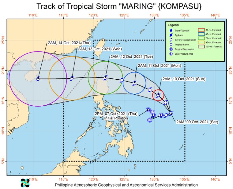
A near-term erratic movement remains likely in the next 24 hours as the circulations of both tropical cyclones interact with each other in a potential merger event. Afterwards, the resulting merger, likely dominated by 'Maring', is forecast to move northwestward and west northwestward until Monday before turning westward by Tuesday.
On the forecast track, the storm will cross the Luzon Strait and pass over or close to Batanes and Babuyan Islands between Monday evening and Tuesday morning.
'Maring' may likely persist in the merger event with 'Nando', which may take place within the next 36 hours. The resulting merger cyclone is forecast to continue intensifying within the forecast period and may reach severe tropical storm category within 36 hours.
Considering the trend of changes in the forecast scenario in previous bulletins and the uncertainty surrounding the interaction and merger event between the cyclones, there is a moderate to high likelihood that changes may still occur in the track and intensity outlook for this tropical depression in the next bulletin.
HAZARDS AFFECTING LAND AREAS
Heavy Rainfall
Today, moderate to heavy rains are possible over Eastern Visayas and Dinagat Islands. Light to moderate with at times heavy rains are also possible over Bicol Region and the rest of Visayas and Caraga.
Beginning this afternoon or evening, light to moderate with at times heavy rains may also begin affecting Palawan and Occidental Mindoro as the southwesterlies enhanced by 'Maring' begin affecting these areas.
Under these conditions, isolated to scattered flooding (including flash floods) and rain-induced landslides are possible especially in areas that are highly or very highly susceptible to these hazard as identified in hazard maps.
Severe Winds
Due to the expansive wind field of the tropical storm, occasionally gusts reaching strong breeze to near gale in strength may still be experienced over Eastern Visayas, Caraga, Catanduanes, Albay, and Sorsogon even in the absence of a wind signal.
Current forecast scenario that there is moderate to high likelihood that TCWS No. 1 will be hoisted for some localities in Northern Luzon beginning today or tomorrow in anticipation of the arrival of strong breeze to near gale conditions with higher gusts. The highest possible wind signal for this tropical cyclone remains TCWS No. 2.
Due to the expansive wind field of 'Maring', the uncertainty in its interaction and possible merging with Tropical Depression “NANDO”, and the track and intensity forecast post-merger, there is a possibility that areas outside Northern Luzon may also be placed under TCWS and that a higher wind signal may still be hoisted within the forecast period.
HAZARDS AFFECTING COASTAL WATERS
Under the influence of Tropical Storm 'Maring', a Gale Warning is in effect for eastern seaboards of Southern Luzon, Visayas, and Mindanao.
In the next 24 hours, moderate to rough seas will prevail over the eastern seaboards of the country that are not under Gale Warning and the western seaboard of Luzon. These conditions are risky for those using small seacrafts. Mariners are advised to take precautionary measures when venturing out to sea and, if possible, avoid navigating in these conditions.
TROPICAL CYCLONES
'Maring' and 'Nando' are the 13th and 14th tropical cyclone this year. 'Maring' developed into a tropical depression while east of Bicol region on Thursday afternoon, October 7.
PAGASA predicts that 2–3 tropical cyclones may enter/develop in the Philippine Area of Responsibility (PAR) this month. On October 4, tropical depression 'Lannie' developed while east of Surigao del Norte and made 10 landfalls across northern Mindanao, the Visayas, and Palawan.
On average, there are 20 tropical cyclones that could form or enter the PAR each year. Only half of those are projected to make landfall.
The weather agency declared the onset of the rainy season on Friday, June 5.
— The Summit Express
No Tropical Cyclone Wind Signal is currently in effect.
Meanwhile, another tropical depression entered the Philippine area of responsibility (PAR) on Friday and was named Nando. At 4:00 am today, it was last located 1,105 km east of northern Luzon packing maximum sustained winds of 55 kph near the center with 70 kph gusts while moving west at 25 kph.
 |
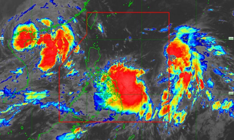
| Satellite image of Bagyong 'Maring' and 'Nando' as of 5:40 am, October 9, 2021. Photo from PAGASA |
TRACK AND INTENSITY OUTLOOK
Both 'Maring' and Tropical Depression 'Nando' are presently embedded within the larger circulation of a monsoon depression.
A near-term erratic movement remains likely in the next 24 hours as the circulations of both tropical cyclones interact with each other in a potential merger event. Afterwards, the resulting merger, likely dominated by 'Maring', is forecast to move northwestward and west northwestward until Monday before turning westward by Tuesday.
On the forecast track, the storm will cross the Luzon Strait and pass over or close to Batanes and Babuyan Islands between Monday evening and Tuesday morning.
'Maring' may likely persist in the merger event with 'Nando', which may take place within the next 36 hours. The resulting merger cyclone is forecast to continue intensifying within the forecast period and may reach severe tropical storm category within 36 hours.
Considering the trend of changes in the forecast scenario in previous bulletins and the uncertainty surrounding the interaction and merger event between the cyclones, there is a moderate to high likelihood that changes may still occur in the track and intensity outlook for this tropical depression in the next bulletin.
Press Briefing: TS "#MaringPH" and TD "#NandoPH" Saturday, 5:00 AM October 9, 2021Press Briefing: TS "#MaringPH" and TD "#NandoPH" Saturday, 5:00 AM October 9, 2021 DOST-PAGASA Weather Specialist: Ezra Bulquerin
Posted by Dost_pagasa on Friday, October 8, 2021
HAZARDS AFFECTING LAND AREAS
Heavy Rainfall
Today, moderate to heavy rains are possible over Eastern Visayas and Dinagat Islands. Light to moderate with at times heavy rains are also possible over Bicol Region and the rest of Visayas and Caraga.
Beginning this afternoon or evening, light to moderate with at times heavy rains may also begin affecting Palawan and Occidental Mindoro as the southwesterlies enhanced by 'Maring' begin affecting these areas.
Under these conditions, isolated to scattered flooding (including flash floods) and rain-induced landslides are possible especially in areas that are highly or very highly susceptible to these hazard as identified in hazard maps.
Severe Winds
Due to the expansive wind field of the tropical storm, occasionally gusts reaching strong breeze to near gale in strength may still be experienced over Eastern Visayas, Caraga, Catanduanes, Albay, and Sorsogon even in the absence of a wind signal.
Current forecast scenario that there is moderate to high likelihood that TCWS No. 1 will be hoisted for some localities in Northern Luzon beginning today or tomorrow in anticipation of the arrival of strong breeze to near gale conditions with higher gusts. The highest possible wind signal for this tropical cyclone remains TCWS No. 2.
Due to the expansive wind field of 'Maring', the uncertainty in its interaction and possible merging with Tropical Depression “NANDO”, and the track and intensity forecast post-merger, there is a possibility that areas outside Northern Luzon may also be placed under TCWS and that a higher wind signal may still be hoisted within the forecast period.
HAZARDS AFFECTING COASTAL WATERS
Under the influence of Tropical Storm 'Maring', a Gale Warning is in effect for eastern seaboards of Southern Luzon, Visayas, and Mindanao.
In the next 24 hours, moderate to rough seas will prevail over the eastern seaboards of the country that are not under Gale Warning and the western seaboard of Luzon. These conditions are risky for those using small seacrafts. Mariners are advised to take precautionary measures when venturing out to sea and, if possible, avoid navigating in these conditions.
TROPICAL CYCLONES
'Maring' and 'Nando' are the 13th and 14th tropical cyclone this year. 'Maring' developed into a tropical depression while east of Bicol region on Thursday afternoon, October 7.
PAGASA predicts that 2–3 tropical cyclones may enter/develop in the Philippine Area of Responsibility (PAR) this month. On October 4, tropical depression 'Lannie' developed while east of Surigao del Norte and made 10 landfalls across northern Mindanao, the Visayas, and Palawan.
On average, there are 20 tropical cyclones that could form or enter the PAR each year. Only half of those are projected to make landfall.
The weather agency declared the onset of the rainy season on Friday, June 5.
— The Summit Express

