MANILA, Philippines – 'Bagyong Kiko' (international name: Chanthu) slightly weakens over the Philippine Sea east of southern Isabela, state weather bureau PAGASA announced in its 5:00 am update on Friday, September 10, 2021.
SEE ALSO: 'Bagyong Kiko' PAGASA weather update September 11, 2021
SEE ALSO: 'Bagyong Kiko' PAGASA weather update September 11, 2021
At 4:00 am today, the eye of Typhoon 'Kiko' was located based on all available data including those from Daet Doppler Weather Radar at 280 km East Northeast of Casiguran, Aurora.
'Bagyong Kiko' has maximum sustained winds of 185 km/h near the center, gustiness of up to 230 km/h, and central pressure of 935 hPa. It is moving west northwestward at 20 km/h.
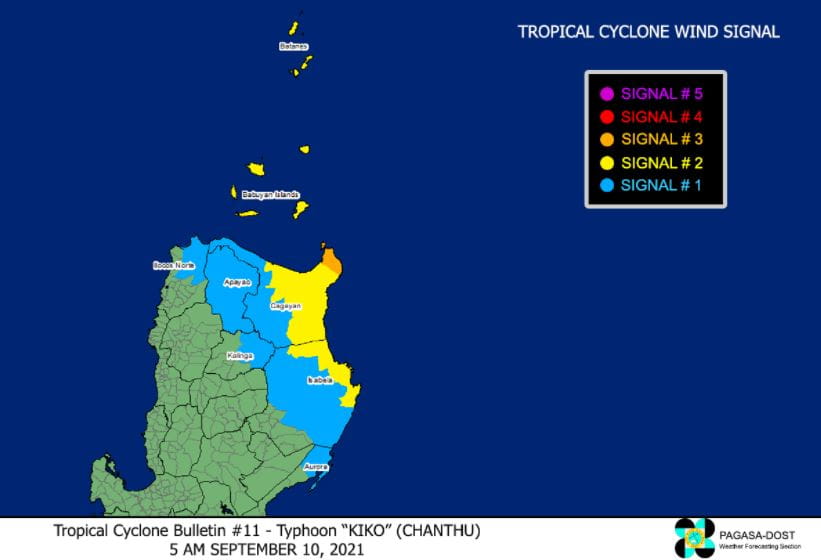
TROPICAL CYCLONE WIND SIGNALS IN EFFECT
TCWS No. 3 (Destructive typhoon-force winds prevailing or expected within 18 hours)
TCWS No. 2 (Damaging gale-force to storm-force winds prevailing or expected within 24 hours)
Luzon
TCWS No. 1 (Strong winds prevailing or expected within 36 hours)
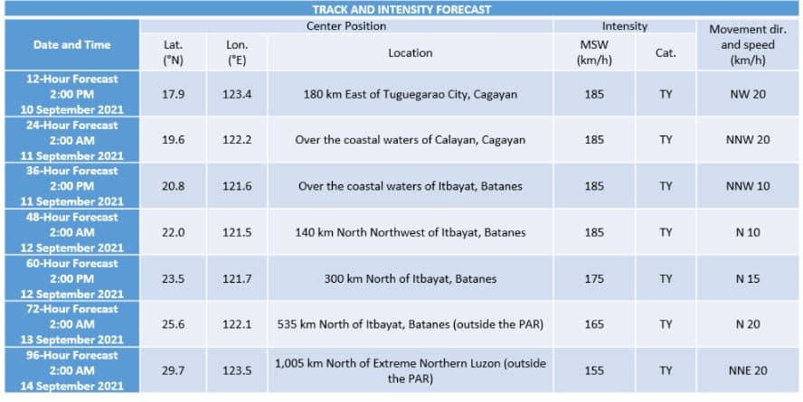
TRACK AND INTENSITY OUTLOOK
Typhoon 'Kiko' is forecast to move generally northwestward or north northwestward towards the Babuyan Islands-Batanes area.
On the forecast track, the typhoon is forecast to pass over the coastal waters of northeastern Cagayan this afternoon or evening. Afterwards, the typhoon may cross the vicinity of Babuyan Islands and Batanes or pass within their coastal waters tonight through tomorrow afternoon or evening.
The possibility of landfall over the northeastern portion of Cagayan is not yet ruled out. As such, the public is advised to continue monitoring for possible changes in the track forecast in the succeeding bulletins.
After passing in the vicinity of Extreme Northern Luzon, 'Kiko' is forecast to move northward for the remainder of tomorrow through Sunday afternoon and may make landfall in the vicinity of eastern Taiwan or pass within its coastal waters. The typhoon is forecast to exit the Philippine Area of Responsibility (PAR) on Sunday afternoon or evening. Outside the PAR, the typhoon will turn north northeastward over the East China Sea.
The typhoon is forecast to maintain that intensity until it moves past Extreme Northern Luzon. Further weakening will begin on Sunday as the typhoon begins to interact with the rugged terrain of Taiwan but will remain within typhoon category throughout the forecast period.
HAZARDS AFFECTING LAND AREAS
Heavy Rainfall
This afternoon through tomorrow evening, heavy to intense with at times torrential rains due to the typhoon may be experienced over Cagayan including Babuyan Islands, Batanes, and northern Isabela.
Moderate to heavy with at times intense rains may be experienced over Ilocos Region, Cordillera Administrative Region, northern and central Aurora, and the rest of Cagayan Valley.
Under these conditions, scattered to widespread flooding (including flash floods) and rain-induced landslides are possible especially in areas that are highly or very highly susceptible to these hazard as identified in hazard maps.
Severe Tropical Storm 'Jolina' and Typhoon 'Kiko' will continue to enhance the Southwest Monsoon, bringing monsoon rains over the western sections of Central Luzon, Southern Luzon, and Visayas in the next 24 hours.
Severe Winds
Winds may reach typhoon-force winds in strength within any of the areas where Signal No. 3 is hoisted during the passage of the typhoon. This may cause generally moderate to heavy damage to structures and vegetation.
Winds may reach gale to storm force in strength within any of the areas where Signal No. 2 is in effect. This may result to light to moderate damage to structures and vegetation.
Winds reaching strong breeze to near gale in strength (i.e., strong winds) will be felt within any of the areas where Signal No. 1 is in effect. This may result to up to very light damage to structures and vegetation.
It must be noted that as the typhoon progresses towards Extreme Northern Luzon, higher wind signals will be hoisted in some localities within Northern Luzon. Based on the latest track and intensity forecast, Signal No. 4 remains the highest wind signal that will be hoisted for this typhoon.
The enhanced Southwest Monsoon will bring occasional gusts reaching strong breeze to near gale in strength over the coastal and upland/mountain areas of the western sections of Central Luzon, Southern Luzon, and Visayas in the next 24 hours.
Coastal Inundation
A moderate risk of storm surge reaching 1.0 to 2.0 m in height may occur in the next 24 hours.
Rising sea water along with the high waves from the shoreline moving inland may cause flooding in the low-lying coastal localities of Batanes, Cagayan including Babuyan Islands, and Isabela.
HAZARDS AFFECTING COASTAL WATERS
In the next 24 hours, rough to very high seas (2.5 to 10.0 m) will be experienced over the seaboards of areas where TCWS is in effect. Sea travel is risky for all types of sea vessels. Mariners are advised to remain in port or take shelter in port until winds and waves subside.
Moderate to rough seas (1.2 to 3.0 m) will be experienced over the eastern seaboards of Central and Southern Luzon. Sea travel is risky for those using small seacrafts. Mariners are advised to take precautionary measures when venturing out to sea and, if possible, avoid navigating in these conditions.
Due to the typhoon enhancing the Southwest Monsoon, a Gale Warning is currently in effect for the western seaboards of Palawan including Calamian and Kalayaan Islands and Occidental Mindoro including Lubang Islands.
TROPICAL CYCLONES
'Kiko', the 11th tropical cyclone for 2021, enters PAR on Tuesday, September 7.
PAGASA predicts that 2–3 tropical cyclones may enter/develop in the PAR this month.
On average, there are 20 tropical cyclones that could form or enter the PAR each year. Only half of those are projected to make landfall.
The weather agency declared the onset of the rainy season on Friday, June 5.
— The Summit Express
 |
| Satellite image of 'Bagyong Kiko' as of 4:30 am, September 10, 2021. Photo from PAGASA |
'Bagyong Kiko' has maximum sustained winds of 185 km/h near the center, gustiness of up to 230 km/h, and central pressure of 935 hPa. It is moving west northwestward at 20 km/h.
TROPICAL CYCLONE WIND SIGNALS IN EFFECT
TCWS No. 3 (Destructive typhoon-force winds prevailing or expected within 18 hours)
- The extreme northeastern portion of Cagayan (Santa Ana)
TCWS No. 2 (Damaging gale-force to storm-force winds prevailing or expected within 24 hours)
Luzon
- Batanes
- Babuyan Islands
- the remaining eastern portion of mainland Cagayan (Aparri, Camalaniugan, Lal-Lo, Gattaran, Baggao, Peñablanca, Buguey, Santa Teresita, Gonzaga)
- the northeastern portion of Isabela (San Pablo, Maconacon, Divilacan, Palanan)
TCWS No. 1 (Strong winds prevailing or expected within 36 hours)
- the rest of mainland Cagayan
- the northeastern portion of Ilocos Norte (Pagudpud, Adams, Dumalneg, Bangui, Vintar, Carasi)
- Apayao
- the eastern portion of Kalinga (City of Tabuk, Pinukpuk, Rizal)
- the northwestern and southeastern portions of Isabela (Santa Maria, Quezon, Mallig, Roxas, San Manuel, Cabatuan, Aurora, City of Cauayan, Angadanan, San Guillermo, Dinapigue, San Mariano, Cabagan, Santo Tomas, Delfin Albano, Tumauini, Quirino, Burgos, Gamu, Ilagan City, Luna, Reina Mercedes, Naguilian, Benito Soliven)
- the northern portion of Aurora (Dilasag, Casiguran)
TRACK AND INTENSITY OUTLOOK
Typhoon 'Kiko' is forecast to move generally northwestward or north northwestward towards the Babuyan Islands-Batanes area.
On the forecast track, the typhoon is forecast to pass over the coastal waters of northeastern Cagayan this afternoon or evening. Afterwards, the typhoon may cross the vicinity of Babuyan Islands and Batanes or pass within their coastal waters tonight through tomorrow afternoon or evening.
The possibility of landfall over the northeastern portion of Cagayan is not yet ruled out. As such, the public is advised to continue monitoring for possible changes in the track forecast in the succeeding bulletins.
After passing in the vicinity of Extreme Northern Luzon, 'Kiko' is forecast to move northward for the remainder of tomorrow through Sunday afternoon and may make landfall in the vicinity of eastern Taiwan or pass within its coastal waters. The typhoon is forecast to exit the Philippine Area of Responsibility (PAR) on Sunday afternoon or evening. Outside the PAR, the typhoon will turn north northeastward over the East China Sea.
The typhoon is forecast to maintain that intensity until it moves past Extreme Northern Luzon. Further weakening will begin on Sunday as the typhoon begins to interact with the rugged terrain of Taiwan but will remain within typhoon category throughout the forecast period.
HAZARDS AFFECTING LAND AREAS
Heavy Rainfall
This afternoon through tomorrow evening, heavy to intense with at times torrential rains due to the typhoon may be experienced over Cagayan including Babuyan Islands, Batanes, and northern Isabela.
Moderate to heavy with at times intense rains may be experienced over Ilocos Region, Cordillera Administrative Region, northern and central Aurora, and the rest of Cagayan Valley.
Under these conditions, scattered to widespread flooding (including flash floods) and rain-induced landslides are possible especially in areas that are highly or very highly susceptible to these hazard as identified in hazard maps.
Severe Tropical Storm 'Jolina' and Typhoon 'Kiko' will continue to enhance the Southwest Monsoon, bringing monsoon rains over the western sections of Central Luzon, Southern Luzon, and Visayas in the next 24 hours.
Severe Winds
Winds may reach typhoon-force winds in strength within any of the areas where Signal No. 3 is hoisted during the passage of the typhoon. This may cause generally moderate to heavy damage to structures and vegetation.
Winds may reach gale to storm force in strength within any of the areas where Signal No. 2 is in effect. This may result to light to moderate damage to structures and vegetation.
Winds reaching strong breeze to near gale in strength (i.e., strong winds) will be felt within any of the areas where Signal No. 1 is in effect. This may result to up to very light damage to structures and vegetation.
It must be noted that as the typhoon progresses towards Extreme Northern Luzon, higher wind signals will be hoisted in some localities within Northern Luzon. Based on the latest track and intensity forecast, Signal No. 4 remains the highest wind signal that will be hoisted for this typhoon.
The enhanced Southwest Monsoon will bring occasional gusts reaching strong breeze to near gale in strength over the coastal and upland/mountain areas of the western sections of Central Luzon, Southern Luzon, and Visayas in the next 24 hours.
Coastal Inundation
A moderate risk of storm surge reaching 1.0 to 2.0 m in height may occur in the next 24 hours.
Rising sea water along with the high waves from the shoreline moving inland may cause flooding in the low-lying coastal localities of Batanes, Cagayan including Babuyan Islands, and Isabela.
HAZARDS AFFECTING COASTAL WATERS
In the next 24 hours, rough to very high seas (2.5 to 10.0 m) will be experienced over the seaboards of areas where TCWS is in effect. Sea travel is risky for all types of sea vessels. Mariners are advised to remain in port or take shelter in port until winds and waves subside.
Moderate to rough seas (1.2 to 3.0 m) will be experienced over the eastern seaboards of Central and Southern Luzon. Sea travel is risky for those using small seacrafts. Mariners are advised to take precautionary measures when venturing out to sea and, if possible, avoid navigating in these conditions.
Due to the typhoon enhancing the Southwest Monsoon, a Gale Warning is currently in effect for the western seaboards of Palawan including Calamian and Kalayaan Islands and Occidental Mindoro including Lubang Islands.
TROPICAL CYCLONES
'Kiko', the 11th tropical cyclone for 2021, enters PAR on Tuesday, September 7.
PAGASA predicts that 2–3 tropical cyclones may enter/develop in the PAR this month.
On average, there are 20 tropical cyclones that could form or enter the PAR each year. Only half of those are projected to make landfall.
The weather agency declared the onset of the rainy season on Friday, June 5.
— The Summit Express


