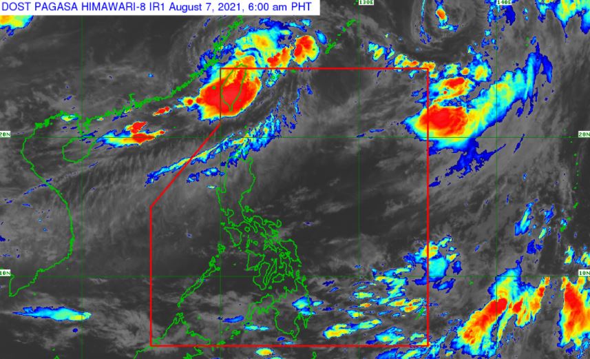
MANILA, Philippines – Southwest Monsoon or hanging habagat still affecting Luzon and Visayas, state weather bureau PAGASA announced in its 4:00 am update on Saturday, August 7, 2021.
SEE ALSO: PAGASA weather update August 8, 2021
SEE ALSO: PAGASA weather update August 8, 2021
Forecast Weather Conditions
Moderate to at times heavy rains, due to Southwest Monsoon may bring flash floods or landslides in the following areas:
Metro Manila and the rest of the country may experience partly cloudy to cloudy skies with isolated rainshowers or thunderstorms. It may cause flash floods or landslides during severe thunderstorms.
OTHER WEATHER SYSTEMS
PAGASA monitors two (2) weather systems outside the Philippine Area of Responsibility (PAR).
Tropical Storm Mirinae (formerly Gorio): spotted at 1,725 km east northeast of Extreme Northern Luzon with maximum sustained winds of 75 km/h near the center and gustiness of up to 90 km/h. It is moving north northwestward at 30 km/h.
Tropical Storm Lupit: tracked at 535 km northwest of Itbayat, Batanes with maximum sustained winds of 65 km/h near the center and gustiness of up to 80 km/h. It is moving slowly at east northeastward.
Forecast Wind and Coastal Water Conditions
Area: Luzon and Visayas
Wind Speed: Moderate to Strong
Wind Direction: Southwest
Coastal Waters: Moderate to Strong / (1.2 to 4.0 meters)
Area: Mindanao
Wind Speed: Light to Moderate
Wind Direction: South to Southwest
Coastal Waters: Slight to Moderate / (0.6 to 2.1 meters)
On average, there are 20 tropical cyclones that could form or enter the PAR each year. Only half of those are projected to make landfall.
PAGASA predicts that 2–3 tropical cyclones may enter the PAR this month.
The weather agency declared the onset of the rainy season on Friday, June 5.
— The Summit Express
 |
| Satellite image of Southwest Monsoon and other weather systems as of 6:00 am, August 7, 2021. via DOST-PAGASA |
Moderate to at times heavy rains, due to Southwest Monsoon may bring flash floods or landslides in the following areas:
- Ilocos Region
- Zambales
- Benguet
- Batanes
- Babuyan Islands
Metro Manila and the rest of the country may experience partly cloudy to cloudy skies with isolated rainshowers or thunderstorms. It may cause flash floods or landslides during severe thunderstorms.
OTHER WEATHER SYSTEMS
PAGASA monitors two (2) weather systems outside the Philippine Area of Responsibility (PAR).
Tropical Storm Mirinae (formerly Gorio): spotted at 1,725 km east northeast of Extreme Northern Luzon with maximum sustained winds of 75 km/h near the center and gustiness of up to 90 km/h. It is moving north northwestward at 30 km/h.
Tropical Storm Lupit: tracked at 535 km northwest of Itbayat, Batanes with maximum sustained winds of 65 km/h near the center and gustiness of up to 80 km/h. It is moving slowly at east northeastward.
Public Weather Forecast Issued at 4:00 AM August 7, 2021Public Weather Forecast Issued at 4:00 AM August 7, 2021 DOST-PAGASA Weather Specialist: Ezra Bulquerin
Posted by Dost_pagasa on Friday, August 6, 2021
Forecast Wind and Coastal Water Conditions
Area: Luzon and Visayas
Wind Speed: Moderate to Strong
Wind Direction: Southwest
Coastal Waters: Moderate to Strong / (1.2 to 4.0 meters)
Area: Mindanao
Wind Speed: Light to Moderate
Wind Direction: South to Southwest
Coastal Waters: Slight to Moderate / (0.6 to 2.1 meters)
On average, there are 20 tropical cyclones that could form or enter the PAR each year. Only half of those are projected to make landfall.
PAGASA predicts that 2–3 tropical cyclones may enter the PAR this month.
The weather agency declared the onset of the rainy season on Friday, June 5.
— The Summit Express

