MANILA, Philippines – 'Bagyong Isang' (international name: Omais) intensified into a severe tropical storm as it approaches the waters off Miyako Islands in the southern Ryukus of Japan, state weather bureau PAGASA announced in its 5:00 am update on Sunday, August 21, 2021.
As of 4:00 am today, the center of Severe Tropical Storm 'Isang' was estimated based on all available data at 560 km Northeast of Itbayat, Batanes.
'Bagyong Isang' has maximum sustained winds of 95 km/h near the center, gustiness of up to 115 km/h, and central pressure of 996 hPa. It is moving Northwestward at 20 km/h.
PAGASA said strong winds or higher extend outward up to 240 km from the center.
TROPICAL CYCLONE WIND SIGNALS
No Tropical Cyclone Wind Signal is currently in effect.
TRACK AND INTENSITY OUTLOOK
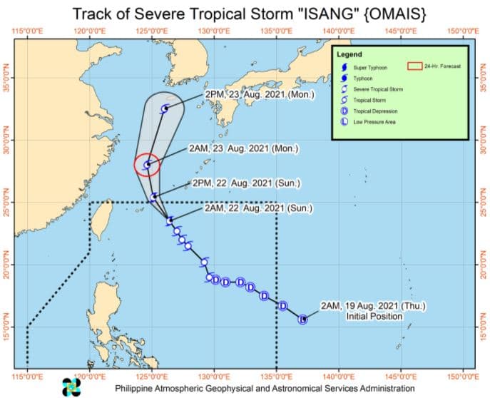
'Isang' is forecast to move generally northwestward or north northwestward in the next 24 hours.
On the forecast track, the severe tropical storm will likely pass near or over the Miyako Islands in the southern portion of the Ryukyu Archipelago and exit the Philippine Area of Responsibility this noon or afternoon.
Outside the PAR region, 'Isang' is forecast to turn more northward tonight as it moves over the East China Sea, then north northeastward on Monday towards the Jeju Island and the Korean Peninsula.
It was upgraded to severe tropical storm category at 2:00 AM today. It is forecast to maintain its strength today as it moves past the southern Ryukyus and towards the East China Sea.
A weakening trend may begin tomorrow, which will result in 'Isang' being downgraded into a tropical storm.
HAZARDS AFFECTING LAND AREAS
Heavy Rainfall
'Isang' is unlikely to directly affect the weather condition and bring heavy rainfall in the country throughout the forecast period.
Severe Winds
The latest forecast scenario for 'Isang' shows that the hoisting of Tropical Cyclone Wind Signals over any land area in the country remains unlikely. Moreover, its passage is unlikely to enhance the Southwest Monsoon and bring gusty conditions to the country.
HAZARDS AFFECTING COASTAL WATERS
In the next 24 hours, Severe Tropical Storm 'Isang' remains less likely to cause sea conditions within the coastal waters of the country which may be risky to any type of sea vessel.
TROPICAL CYCLONES
'Isang', the ninth tropical cyclone for 2021, entered the PAR at 10 am on Thursday, August 19.
On average, there are 20 tropical cyclones that could form or enter the PAR each year. Only half of those are projected to make landfall.
The weather agency declared the onset of the rainy season on Friday, June 5.
— The Summit Express
As of 4:00 am today, the center of Severe Tropical Storm 'Isang' was estimated based on all available data at 560 km Northeast of Itbayat, Batanes.
 |
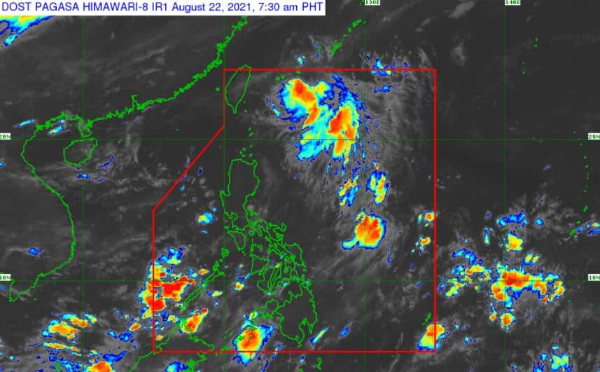
| Satellite image of Severe Tropical Storm 'Isang' as of 7:30 am, August 22, 2021. via DOST-PAGASA |
'Bagyong Isang' has maximum sustained winds of 95 km/h near the center, gustiness of up to 115 km/h, and central pressure of 996 hPa. It is moving Northwestward at 20 km/h.
PAGASA said strong winds or higher extend outward up to 240 km from the center.
TROPICAL CYCLONE WIND SIGNALS
No Tropical Cyclone Wind Signal is currently in effect.
TRACK AND INTENSITY OUTLOOK
'Isang' is forecast to move generally northwestward or north northwestward in the next 24 hours.
On the forecast track, the severe tropical storm will likely pass near or over the Miyako Islands in the southern portion of the Ryukyu Archipelago and exit the Philippine Area of Responsibility this noon or afternoon.
Outside the PAR region, 'Isang' is forecast to turn more northward tonight as it moves over the East China Sea, then north northeastward on Monday towards the Jeju Island and the Korean Peninsula.
It was upgraded to severe tropical storm category at 2:00 AM today. It is forecast to maintain its strength today as it moves past the southern Ryukyus and towards the East China Sea.
A weakening trend may begin tomorrow, which will result in 'Isang' being downgraded into a tropical storm.
HAZARDS AFFECTING LAND AREAS
Heavy Rainfall
'Isang' is unlikely to directly affect the weather condition and bring heavy rainfall in the country throughout the forecast period.
Severe Winds
The latest forecast scenario for 'Isang' shows that the hoisting of Tropical Cyclone Wind Signals over any land area in the country remains unlikely. Moreover, its passage is unlikely to enhance the Southwest Monsoon and bring gusty conditions to the country.
HAZARDS AFFECTING COASTAL WATERS
In the next 24 hours, Severe Tropical Storm 'Isang' remains less likely to cause sea conditions within the coastal waters of the country which may be risky to any type of sea vessel.
TROPICAL CYCLONES
'Isang', the ninth tropical cyclone for 2021, entered the PAR at 10 am on Thursday, August 19.
On average, there are 20 tropical cyclones that could form or enter the PAR each year. Only half of those are projected to make landfall.
The weather agency declared the onset of the rainy season on Friday, June 5.
— The Summit Express


