MANILA, Philippines – 'Bagyong Isang' (international name: Omais) gains strength and is now moving northwestward over the Philippine Sea, state weather bureau PAGASA announced in its 11:00 am update on Saturday, August 21, 2021.
SEE ALSO: 'Bagyong Isang' PAGASA weather update August 22, 2021
SEE ALSO: 'Bagyong Isang' PAGASA weather update August 22, 2021
As of 10:00 am today, the center of Tropical Storm 'Isang' was estimated based on all available data at 605 km East Northeast of Basco or Itbayat, Batanes.
'Bagyong Isang' has maximum sustained winds of 75 km/h near the center, gustiness of up to 90 km/h, and central pressure of 1002 hPa. It is moving Northwestward at 30 km/h.
PAGASA said that strong winds or higher extend outward up to 160 km from the center.
TROPICAL CYCLONE WIND SIGNALS
No Tropical Cyclone Wind Signal is currently in effect.
TRACK AND INTENSITY OUTLOOK
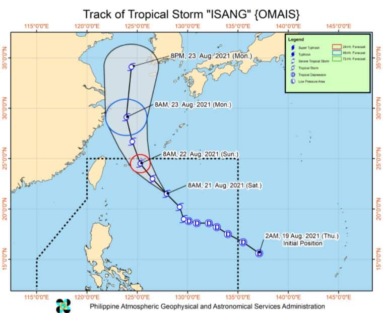
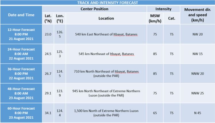
'Isang' will remain far from the Philippine landmass throughout the forecast period. The tropical storm is forecast to move generally northwestward today through tomorrow, turn north northwestward tomorrow evening over the East China Sea, then northward on Monday evening.
On the forecast track, the tropical storm is forecast to exit the Philippine Area of Responsibility (PAR) tomorrow morning or afternoon.
This tropical storm is forecast to continue to intensify until tomorrow morning, when it is likely to reach its peak intensity. A weakening trend may commence by Sunday evening.
HAZARDS AFFECTING LAND AREAS
Heavy Rainfall
'Isang' is unlikely to directly affect the weather condition and bring heavy rainfall in the country throughout the forecast period.
Severe Winds
The latest forecast scenario shows that the hoisting of Tropical Cyclone Wind Signals over any land area in the country remains unlikely.
Moreover, its passage is unlikely to enhance the Southwest Monsoon and bring gusty conditions to the country.
HAZARDS AFFECTING COASTAL WATERS
In the next 24 hours, Tropical Storm 'Isang' remains less likely to cause sea conditions within the coastal waters of the country which may be risky to any type of sea vessel.
TROPICAL CYCLONES
'Isang', the ninth tropical cyclone for 2021, entered the PAR at 10 am on Thursday, August 19.
On average, there are 20 tropical cyclones that could form or enter the PAR each year. Only half of those are projected to make landfall.
The weather agency declared the onset of the rainy season on Friday, June 5.
— The Summit Express
 |
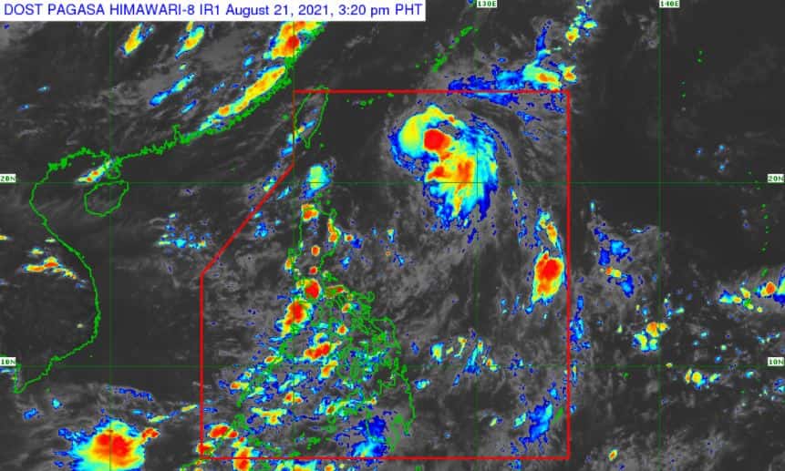
| Satellite image of Tropical Storm 'Isang' as of 3:20 pm, August 21, 2021. via DOST-PAGASA |
'Bagyong Isang' has maximum sustained winds of 75 km/h near the center, gustiness of up to 90 km/h, and central pressure of 1002 hPa. It is moving Northwestward at 30 km/h.
PAGASA said that strong winds or higher extend outward up to 160 km from the center.
TROPICAL CYCLONE WIND SIGNALS
No Tropical Cyclone Wind Signal is currently in effect.
TRACK AND INTENSITY OUTLOOK
'Isang' will remain far from the Philippine landmass throughout the forecast period. The tropical storm is forecast to move generally northwestward today through tomorrow, turn north northwestward tomorrow evening over the East China Sea, then northward on Monday evening.
On the forecast track, the tropical storm is forecast to exit the Philippine Area of Responsibility (PAR) tomorrow morning or afternoon.
This tropical storm is forecast to continue to intensify until tomorrow morning, when it is likely to reach its peak intensity. A weakening trend may commence by Sunday evening.
HAZARDS AFFECTING LAND AREAS
Heavy Rainfall
'Isang' is unlikely to directly affect the weather condition and bring heavy rainfall in the country throughout the forecast period.
Severe Winds
The latest forecast scenario shows that the hoisting of Tropical Cyclone Wind Signals over any land area in the country remains unlikely.
Moreover, its passage is unlikely to enhance the Southwest Monsoon and bring gusty conditions to the country.
HAZARDS AFFECTING COASTAL WATERS
In the next 24 hours, Tropical Storm 'Isang' remains less likely to cause sea conditions within the coastal waters of the country which may be risky to any type of sea vessel.
TROPICAL CYCLONES
'Isang', the ninth tropical cyclone for 2021, entered the PAR at 10 am on Thursday, August 19.
On average, there are 20 tropical cyclones that could form or enter the PAR each year. Only half of those are projected to make landfall.
The weather agency declared the onset of the rainy season on Friday, June 5.
— The Summit Express


