MANILA, Philippines – 'Bagyong Fabian' (international name: In-fa) accelerates northward and is now outside the Philippine Area of Responsibility (PAR), state weather bureau PAGASA announced in its 5:00 am update on Saturday, July 24, 2021.
SEE ALSO: 'Habagat' PAGASA weather update July 25, 2021
SEE ALSO: 'Habagat' PAGASA weather update July 25, 2021
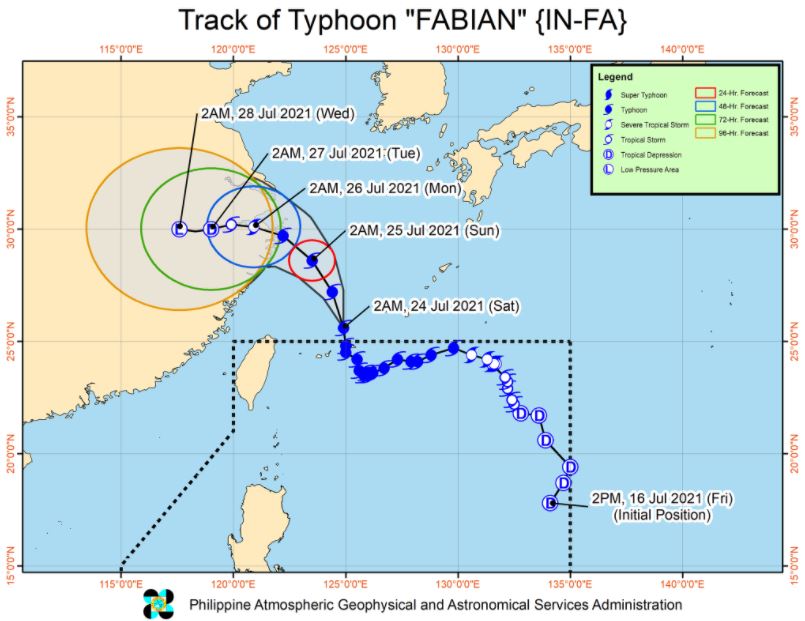
At 4:00 am today, the center of Typhoon 'Fabian' was estimated based on all available data at 640 km North Northeast of Itbayat, Batanes.
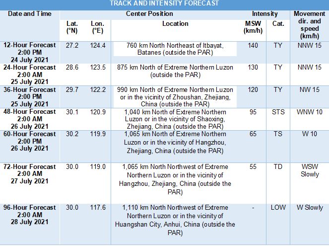
'Bagyong Fabian' has maximum sustained winds of 140 km/h near the center, gustiness of up to 170 km/h, and central pressure of 960 hPa. It is moving northward at 15 km/h.
NOTE: All Tropical Cyclone Wind Signals have been lifted.
TRACK AND INTENSITY OUTLOOK
'Fabian' exited the PAR at 11:00 PM on Friday.
The typhoon is forecast to gradually accelerate while moving generally northwestward over the East China Sea. On the forecast track, 'Fabian' may make landfall in the vicinity of eastern mainland China on Sunday afternoon or evening.
Gradual weakening is expected beginning tomorrow as 'Fabian' moves closer to the China coast.
However, there is an increasing possibility that this typhoon will further weaken as early as today. Nevertheless, 'Fabian' is forecast to rapidly weakening as it moves inland after making landfall over eastern China, eventually leading to its degeneration into a remnant low by Tuesday evening.
HAZARDS AFFECTING LAND AREAS
Heavy Rainfall
Under the influence of the Southwest Monsoon being enhanced by 'Fabian', scattered to widespread monsoon rains will be experienced in the next 24 hours over Ilocos Region, Cordillera Administrative Region, Metro Manila, most of Central Luzon, CALABARZON, and MIMAROPA, and portions of Western Visayas.
Severe Winds
Occasionally gusty conditions associated with the enhanced Southwest Monsoon will be experienced over Luzon and Visayas, especially in the coastal and upland localities of these areas.
HAZARDS AFFECTING COASTAL WATERS
In the next 24 hours, under the influence of the enhanced Southwest Monsoon and the typhoon:
Rough to very rough seas will be experienced over the seaboards of Luzon and the western and central seaboards of Visayas. Sea travel is risky for small seacrafts over these waters. Mariners without the proper experience should immediately seek safe harbor.
Moderate to rough seas will prevail over the remaining seaboards of the country. Mariners of small seacrafts are advised to take precautionary measures when venturing out to sea. Inexperienced mariners should avoid navigating in these conditions.
TROPICAL CYCLONES
'Fabian', the sixth tropical cyclone for 2021, developed into Tropical Depression while inside PAR on Friday, July 16.
PAGASA predicts that 1–3 tropical cyclones may enter the PAR this month.
On average, there are 20 tropical cyclones that could form or enter the PAR each year. Only half of those are projected to make landfall.
The weather agency declared the onset of the rainy season on Friday, June 5.
— The Summit Express
 |
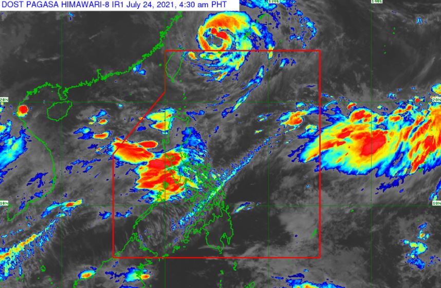
| Satellite image of Typhoon 'Fabian' as of 4:30 am, July 24, 2021. via DOST-PAGASA |
'Bagyong Fabian' has maximum sustained winds of 140 km/h near the center, gustiness of up to 170 km/h, and central pressure of 960 hPa. It is moving northward at 15 km/h.
NOTE: All Tropical Cyclone Wind Signals have been lifted.
TRACK AND INTENSITY OUTLOOK
'Fabian' exited the PAR at 11:00 PM on Friday.
The typhoon is forecast to gradually accelerate while moving generally northwestward over the East China Sea. On the forecast track, 'Fabian' may make landfall in the vicinity of eastern mainland China on Sunday afternoon or evening.
Gradual weakening is expected beginning tomorrow as 'Fabian' moves closer to the China coast.
However, there is an increasing possibility that this typhoon will further weaken as early as today. Nevertheless, 'Fabian' is forecast to rapidly weakening as it moves inland after making landfall over eastern China, eventually leading to its degeneration into a remnant low by Tuesday evening.
HAZARDS AFFECTING LAND AREAS
Heavy Rainfall
Under the influence of the Southwest Monsoon being enhanced by 'Fabian', scattered to widespread monsoon rains will be experienced in the next 24 hours over Ilocos Region, Cordillera Administrative Region, Metro Manila, most of Central Luzon, CALABARZON, and MIMAROPA, and portions of Western Visayas.
Severe Winds
Occasionally gusty conditions associated with the enhanced Southwest Monsoon will be experienced over Luzon and Visayas, especially in the coastal and upland localities of these areas.
HAZARDS AFFECTING COASTAL WATERS
In the next 24 hours, under the influence of the enhanced Southwest Monsoon and the typhoon:
Rough to very rough seas will be experienced over the seaboards of Luzon and the western and central seaboards of Visayas. Sea travel is risky for small seacrafts over these waters. Mariners without the proper experience should immediately seek safe harbor.
Moderate to rough seas will prevail over the remaining seaboards of the country. Mariners of small seacrafts are advised to take precautionary measures when venturing out to sea. Inexperienced mariners should avoid navigating in these conditions.
TROPICAL CYCLONES
'Fabian', the sixth tropical cyclone for 2021, developed into Tropical Depression while inside PAR on Friday, July 16.
PAGASA predicts that 1–3 tropical cyclones may enter the PAR this month.
On average, there are 20 tropical cyclones that could form or enter the PAR each year. Only half of those are projected to make landfall.
The weather agency declared the onset of the rainy season on Friday, June 5.
— The Summit Express


