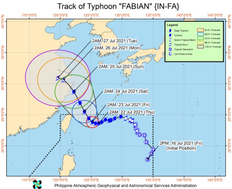
MANILA, Philippines – 'Bagyong Fabian' (international name: In-fa) maintains its strength as it moves west southwestward over the sea southeast of Miyako Islands, state weather bureau PAGASA announced in its 5:00 am update on Thursday, July 22, 2021.
SEE ALSO: 'Bagyong Fabian' PAGASA weather update July 23, 2021
SEE ALSO: 'Bagyong Fabian' PAGASA weather update July 23, 2021
At 4:00 am today, the center of Typhoon 'Fabian' was estimated based on all available data at 530 km Northeast of Itbayat, Batanes.
'Bagyong Fabian' has maximum sustained winds of 150 km/h near the center, gustiness of up to 185 km/h, and central pressure of 955 hPa. It is moving west southwestward at 10 km/h.
TROPICAL CYCLONE WIND SIGNALS IN EFFECT
TCWS No. 1 (Strong winds prevailing or expected within 36 hours)
LUZON: Batanes and Babuyan Islands
TRACK AND INTENSITY OUTLOOK
'Fabian' will move generally westward or west southwestward today, then generally north northwestward for the remainder of the forecast period.
On the forecast track, the typhoon will pass close or make landfall in the vicinity of Miyako, Yaeyama, and Senkaku Islands in the southern Ryukyu Archipelago on tomorrow (July 23).
The cyclone is forecast to exit the Philippine Area of Responsibility (PAR) tomorrow evening or Saturday (July 24) morning.
After traversing the East China Sea, 'Fabian' is forecast to make another landfall over the eastern portion of mainland China on Sunday morning (July 25).
'Fabian' is forecast to continue intensifying and reach its peak intensity (155-165 km/h) tomorrow. A weakening trend in its intensity may begin on Saturday and may accelerate by Sunday as the typhoon makes landfall over mainland China.
HAZARDS AFFECTING LAND AREAS
Heavy Rainfall
'Fabian' is unlikely to directly bring heavy rainfall in the country throughout the forecast period.
Under the influence of the Southwest Monsoon being enhanced by 'Fabian', monsoon rains will be experienced in the next 24 hours over Ilocos Region, Abra, Benguet, Zambales, Bataan, Tarlac, Pampanga, Bulacan, Metro Manila, Cavite, Batangas, Occidental Mindoro, Oriental Mindoro, Romblon, and the northern portion of Palawan including Calamian and Kalayaan Islands.
Severe Winds
Strong winds (strong breeze to near gale conditions) will be experienced over Batanes and Babuyan Islands throughout the passage the typhoon.
HAZARDS AFFECTING COASTAL WATERS
In the next 24 hours, under the influence of the enhanced Southwest Monsoon and Typhoon 'Fabian', rough to very rough seas will be experienced over the northern, western, and eastern seaboards of Luzon (including the areas under TCWS No. 1).
Sea travel is risky for small seacrafts over these waters. Mariners without the proper experience should immediately seek safe harbor.
TROPICAL CYCLONES
'Fabian', the sixth tropical cyclone for 2021, developed into Tropical Depression while inside PAR on Friday, July 16.
PAGASA predicts that 1–3 tropical cyclones may enter the PAR this month.
On average, there are 20 tropical cyclones that could form or enter the PAR each year. Only half of those are projected to make landfall.
The weather agency declared the onset of the rainy season on Friday, June 5.
— The Summit Express


