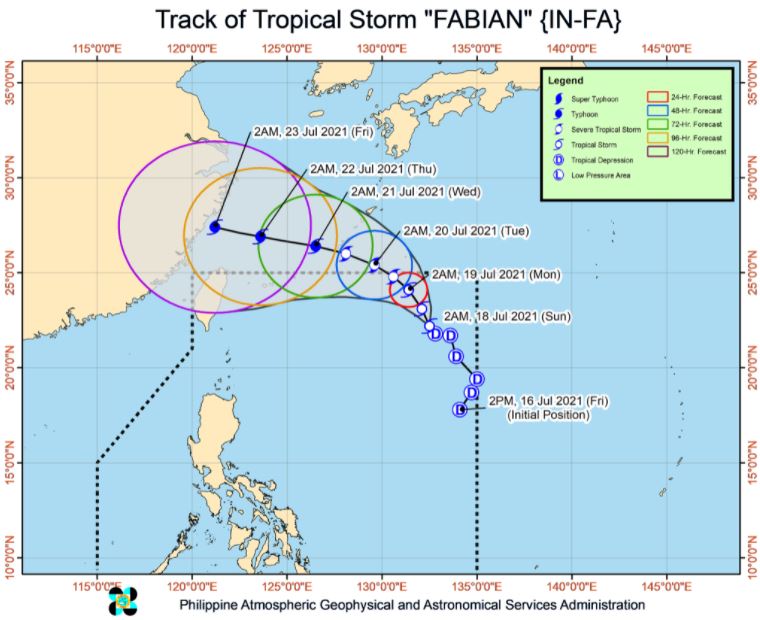
MANILA, Philippines – 'Bagyong Fabian' (international name: In-fa) intensified into a tropical storm, state weather bureau PAGASA announced in its 5:00 am update on Sunday, July 18, 2021.
SEE ALSO: 'Bagyong Fabian' PAGASA weather update July 20, 2021
SEE ALSO: 'Bagyong Fabian' PAGASA weather update July 20, 2021
As of 4:00 am today, the center of Tropical Storm 'Fabian' was estimated based on all available data at 1,090 km East Northeast of Extreme Northern Luzon.
'Bagyong Fabian' has maximum sustained winds of 65 km/h near the center, gustiness of up to 80 km/h, and central pressure of 998 hPa. It is moving north northwestward at 10 km/h.
TROPICAL CYCLONE WIND SIGNALS
No Tropical Cyclone Wind Signal is currently in effect.
The latest forecast scenario shows that the hoisting of TCWS over any land area in the country remains unlikely.
TRACK AND INTENSITY OUTLOOK
'Fabian' will remain far from the Philippine landmass throughout the forecast period. The tropical cyclone will maintain a north northwestward or northwestward heading at a consistent speed until Monday evening, when it is forecast to exit the Philippine Area of Responsibility (PAR).
Outside the PAR, the weather disturbance will move west northwestward beginning Tuesday through the remainder of the forecast period. On the forecast track, the tropical cyclone will pass close or make landfall in the vicinity of the Okinawa Islands in the Ryukyu Archipelago on Tuesday afternoon and reach the East China Sea on the evening of the same day. A landfall over mainland China may likely occur on Friday morning.
'Fabian' intensified into a tropical storm at 2:00 AM today. Further intensification is expected for the remainder of the forecast period, reaching severe tropical storm category by Monday afternoon. It is likely to reach typhoon category by Tuesday evening and reach a peak intensity of 140 km/h before making landfall over mainland China.
HAZARDS AFFECTING LAND AREAS
Heavy Rainfall
'Fabian' is unlikely to bring heavy rainfall in the country throughout the forecast period.
This tropical cyclone and the Low Pressure Area estimated at 630 km West of Calayan, Cagayan (outside the PAR) are currently enhancing the Southwest Monsoon.
Western Visayas, Palawan, and Occidental Mindoro will experience monsoon rains in the next 24 hours.
HAZARDS AFFECTING COASTAL WATERS
In the next 24 hours, Tropical Storm 'Fabian' remains less likely to cause sea conditions within the coastal waters of the country, which may be risky to mariners of any type of sea vessel.
TROPICAL CYCLONES
'Fabian', the sixth tropical cyclone for 2021, developed into Tropical Depression while inside PAR on Friday, July 16.
PAGASA predicts that 1–3 tropical cyclones may enter the PAR this month.
On average, there are 20 tropical cyclones that could form or enter the PAR each year. Only half of those are projected to make landfall.
The weather agency declared the onset of the rainy season on Friday, June 5.
— The Summit Express
 |
| Satellite image of Tropical Storm 'Fabian' as of 5:30 am, July 18, 2021. via DOST-PAGASA |
'Bagyong Fabian' has maximum sustained winds of 65 km/h near the center, gustiness of up to 80 km/h, and central pressure of 998 hPa. It is moving north northwestward at 10 km/h.
TROPICAL CYCLONE WIND SIGNALS
No Tropical Cyclone Wind Signal is currently in effect.
The latest forecast scenario shows that the hoisting of TCWS over any land area in the country remains unlikely.
TRACK AND INTENSITY OUTLOOK
'Fabian' will remain far from the Philippine landmass throughout the forecast period. The tropical cyclone will maintain a north northwestward or northwestward heading at a consistent speed until Monday evening, when it is forecast to exit the Philippine Area of Responsibility (PAR).
Outside the PAR, the weather disturbance will move west northwestward beginning Tuesday through the remainder of the forecast period. On the forecast track, the tropical cyclone will pass close or make landfall in the vicinity of the Okinawa Islands in the Ryukyu Archipelago on Tuesday afternoon and reach the East China Sea on the evening of the same day. A landfall over mainland China may likely occur on Friday morning.
'Fabian' intensified into a tropical storm at 2:00 AM today. Further intensification is expected for the remainder of the forecast period, reaching severe tropical storm category by Monday afternoon. It is likely to reach typhoon category by Tuesday evening and reach a peak intensity of 140 km/h before making landfall over mainland China.
HAZARDS AFFECTING LAND AREAS
Heavy Rainfall
'Fabian' is unlikely to bring heavy rainfall in the country throughout the forecast period.
This tropical cyclone and the Low Pressure Area estimated at 630 km West of Calayan, Cagayan (outside the PAR) are currently enhancing the Southwest Monsoon.
Western Visayas, Palawan, and Occidental Mindoro will experience monsoon rains in the next 24 hours.
HAZARDS AFFECTING COASTAL WATERS
In the next 24 hours, Tropical Storm 'Fabian' remains less likely to cause sea conditions within the coastal waters of the country, which may be risky to mariners of any type of sea vessel.
TROPICAL CYCLONES
'Fabian', the sixth tropical cyclone for 2021, developed into Tropical Depression while inside PAR on Friday, July 16.
PAGASA predicts that 1–3 tropical cyclones may enter the PAR this month.
On average, there are 20 tropical cyclones that could form or enter the PAR each year. Only half of those are projected to make landfall.
The weather agency declared the onset of the rainy season on Friday, June 5.
— The Summit Express


