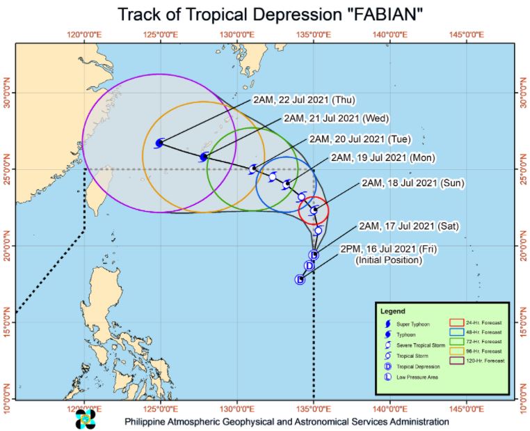
MANILA, Philippines – 'Bagyong Fabian' slightly intensified while moving towards the eastern limit of Philippine Area of Responsibility (PAR), state weather bureau PAGASA announced in its 5:00 am update on Saturday, July 17, 2021.
SEE ALSO: 'Bagyong Fabian' PAGASA weather update July 18, 2021
SEE ALSO: 'Bagyong Fabian' PAGASA weather update July 18, 2021
As of 4:00 am today, the center of Tropical Depression 'Fabian' was estimated based on all available data at 1,365 km East of Extreme Northern Luzon.
'Bagyong Fabian' has maximum sustained winds of 55 km/h near the center, gustiness of up to 70 km/h, and central pressure of 1002 hPa. It is moving North northeastward at 15 km/h.
No Tropical Cyclone Wind Signal is currently in effect.
TRACK AND INTENSITY OUTLOOK
On the forecast track, 'Fabian' will remain far from the Philippine landmass throughout the forecast period. The tropical depression is forecast to move northward or north northwestward until tomorrow early morning. This may bring the center of the storm outside the PAR for a brief period.
After re-entering the PAR, this tropical cyclone will move northwestward or west northwestward until the end of the forecast period. It may exit the PAR (through the northern boundary) between Monday evening and Tuesday morning while moving towards the southern portion of the Ryukyu Islands.
However, due to the uncertainty in model guidance at this portion of the track forecast, there remains a possibility that 'Fabian' may still be inside the PAR beyond Monday.
The weather disturbance is forecast to reach tropical storm category within 12 hours. Furthermore, this tropical cyclone will continue intensifying throughout the remainder of the forecast period and may reach typhoon category by Wednesday evening or Thursday morning.
HAZARDS AFFECTING LAND AREAS
Heavy Rainfall
'Fabian' is unlikely to bring heavy rainfall in the country throughout the forecast period. However, this tropical cyclone is currently enhancing the Southwest Monsoon which may bring monsoon rains over MIMAROPA and the western portion of Visayas within 24 hours.
Severe Winds
The latest forecast scenario for 'Fabian' shows that the hoisting of Tropical Cyclone Wind Signals over any land area in the country remains less likely.
HAZARDS AFFECTING COASTAL WATERS
In the next 24 hours, the tropical depression remains less likely to cause sea conditions within the coastal waters of the country which may be risky to mariners of any type of sea vessel.
TROPICAL CYCLONES
'Fabian', the sixth tropical cyclone for 2021, developed into Tropical Depression while inside PAR on Friday.
PAGASA predicts that 1–3 tropical cyclones may enter the PAR this month.
On average, there are 20 tropical cyclones that could form or enter the PAR each year. Only half of those are projected to make landfall.
The weather agency declared the onset of the rainy season on Friday, June 5.
— The Summit Express
 |
| Satellite image of Tropical Depression 'Fabian' as of 5:40 am, July 17, 2021. via DOST-PAGASA |
'Bagyong Fabian' has maximum sustained winds of 55 km/h near the center, gustiness of up to 70 km/h, and central pressure of 1002 hPa. It is moving North northeastward at 15 km/h.
No Tropical Cyclone Wind Signal is currently in effect.
TRACK AND INTENSITY OUTLOOK
On the forecast track, 'Fabian' will remain far from the Philippine landmass throughout the forecast period. The tropical depression is forecast to move northward or north northwestward until tomorrow early morning. This may bring the center of the storm outside the PAR for a brief period.
After re-entering the PAR, this tropical cyclone will move northwestward or west northwestward until the end of the forecast period. It may exit the PAR (through the northern boundary) between Monday evening and Tuesday morning while moving towards the southern portion of the Ryukyu Islands.
However, due to the uncertainty in model guidance at this portion of the track forecast, there remains a possibility that 'Fabian' may still be inside the PAR beyond Monday.
The weather disturbance is forecast to reach tropical storm category within 12 hours. Furthermore, this tropical cyclone will continue intensifying throughout the remainder of the forecast period and may reach typhoon category by Wednesday evening or Thursday morning.
HAZARDS AFFECTING LAND AREAS
Heavy Rainfall
'Fabian' is unlikely to bring heavy rainfall in the country throughout the forecast period. However, this tropical cyclone is currently enhancing the Southwest Monsoon which may bring monsoon rains over MIMAROPA and the western portion of Visayas within 24 hours.
Severe Winds
The latest forecast scenario for 'Fabian' shows that the hoisting of Tropical Cyclone Wind Signals over any land area in the country remains less likely.
HAZARDS AFFECTING COASTAL WATERS
In the next 24 hours, the tropical depression remains less likely to cause sea conditions within the coastal waters of the country which may be risky to mariners of any type of sea vessel.
TROPICAL CYCLONES
'Fabian', the sixth tropical cyclone for 2021, developed into Tropical Depression while inside PAR on Friday.
PAGASA predicts that 1–3 tropical cyclones may enter the PAR this month.
On average, there are 20 tropical cyclones that could form or enter the PAR each year. Only half of those are projected to make landfall.
The weather agency declared the onset of the rainy season on Friday, June 5.
— The Summit Express


