MANILA, Philippines – 'Bagyong Dante' (international name: Choi-wan) is now moving northwestward towards the vicinity of Yaeyama Islands near the northern limit of the Philippine Area of Responsibility (PAR), state weather bureau PAGASA announced in its 5:00 am update on Saturday, June 5, 2021.
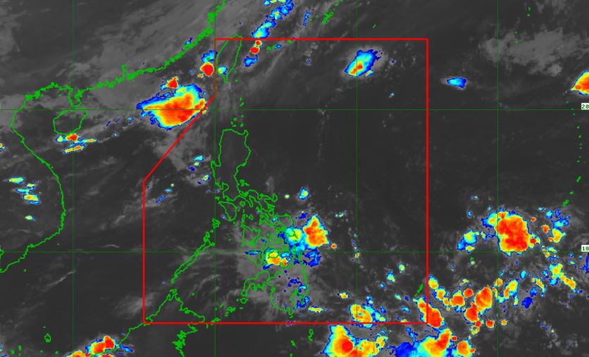
At 4:00 am today, the center of Tropical Depression 'Dante' was estimated based on all available data at 330 km North Northeast of Itbayat, Batanes or over the sea south of Yonaguni Island (Okinawa), Japan.
'Bagyong Dante' has maximum sustained winds of 55 km/h near the center, gustiness up to 70 km/h, and central pressure of 1000 hPa. It is moving northeastward at 30 km/h.
TRACK AND INTENSITY OUTLOOK
'Dante' will continue moving northeastwards and may pass over or near the vicinity of Yaeyama Islands of the Ryukyu archipelago.
On the forecast track, the cyclone is expected to exit the PAR as a tropical depression this morning or early afternoon.
This tropical depression is forecast to transition into an extratropical cyclone within the next 24 hours as it interacts with the baroclinic zone of Mei-yu Front over the East China Sea.
An extratropical cyclone is a large low-pressure weather area with clouds, rain and heavy wind. They are not the same as tropical cyclones or low-pressure weather areas from polar zones. They are actually many masses of cold and warm fronts producing rain, heavy wind, and sometimes tornadoes and even hail.
HAZARDS AFFECTING LAND AREAS
With the lifting of the wind signal in Batanes, Tropical Depression 'Dante' is no longer directly affecting the country.
HAZARDS AFFECTING COASTAL WATERS
Under the influence of 'Dante', moderate to rough seas (1.2 to 3.5 m) will be experienced over the northern seaboard of Northern Luzon.
Mariners of small seacrafts are advised to take precautionary measures when venturing out to sea. Inexperienced mariners should avoid navigating in these conditions.
TROPICAL CYCLONES
'Dante', the fourth tropical cyclone for 2021, entered the PAR early Saturday, May 30.
PAGASA predicts that 1–3 tropical cyclones are expected to enter/develop in the PAR in the June 2021 forecast period.
On average, there are 20 tropical cyclones that could form or enter the PAR each year. Only half of those are projected to make landfall.
The weather agency declared the onset of the rainy season on Friday, June 5.
SEE ALSO: PAGASA officially declares onset of the rainy season
— The Summit Express
At 4:00 am today, the center of Tropical Depression 'Dante' was estimated based on all available data at 330 km North Northeast of Itbayat, Batanes or over the sea south of Yonaguni Island (Okinawa), Japan.
 |
| Satellite image of Tropical Storm 'Dante' as of 4:40 am, June 5, 2021. via DOST-PAGASA |
'Bagyong Dante' has maximum sustained winds of 55 km/h near the center, gustiness up to 70 km/h, and central pressure of 1000 hPa. It is moving northeastward at 30 km/h.
TRACK AND INTENSITY OUTLOOK
'Dante' will continue moving northeastwards and may pass over or near the vicinity of Yaeyama Islands of the Ryukyu archipelago.
On the forecast track, the cyclone is expected to exit the PAR as a tropical depression this morning or early afternoon.
This tropical depression is forecast to transition into an extratropical cyclone within the next 24 hours as it interacts with the baroclinic zone of Mei-yu Front over the East China Sea.
An extratropical cyclone is a large low-pressure weather area with clouds, rain and heavy wind. They are not the same as tropical cyclones or low-pressure weather areas from polar zones. They are actually many masses of cold and warm fronts producing rain, heavy wind, and sometimes tornadoes and even hail.
HAZARDS AFFECTING LAND AREAS
With the lifting of the wind signal in Batanes, Tropical Depression 'Dante' is no longer directly affecting the country.
HAZARDS AFFECTING COASTAL WATERS
Under the influence of 'Dante', moderate to rough seas (1.2 to 3.5 m) will be experienced over the northern seaboard of Northern Luzon.
Mariners of small seacrafts are advised to take precautionary measures when venturing out to sea. Inexperienced mariners should avoid navigating in these conditions.
TROPICAL CYCLONES
'Dante', the fourth tropical cyclone for 2021, entered the PAR early Saturday, May 30.
PAGASA predicts that 1–3 tropical cyclones are expected to enter/develop in the PAR in the June 2021 forecast period.
On average, there are 20 tropical cyclones that could form or enter the PAR each year. Only half of those are projected to make landfall.
The weather agency declared the onset of the rainy season on Friday, June 5.
SEE ALSO: PAGASA officially declares onset of the rainy season
— The Summit Express


