MANILA, Philippines – 'Bagyong Tonyo' has turned west-northwestward and will pass close or over the vicinity of Marinduque and Mindoro Provinces, state weather bureau PAGASA announced in its 5:00 am bulletin on Sunday, November 8, 2020.
However, given the recent shift in the movement direction of the tropical depression, there is an increasing likelihood that its center will make landfall in the vicinity of Southern Quezon or Batangas.
SEE ALSO: 'Bagyong Ulysses' PAGASA weather update November 9, 2020
 |
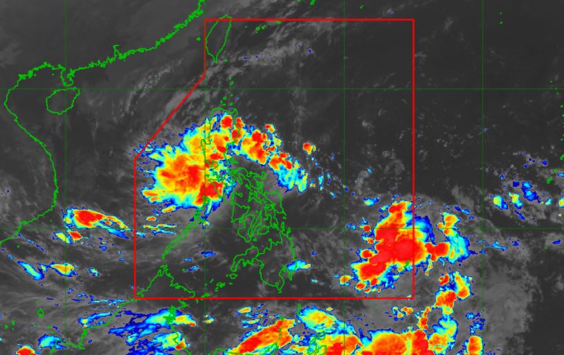
| Satellite image of Tropical Depression Tonyo as of 4:30 am, November 8, 2020. PAGASA |
However, given the recent shift in the movement direction of the tropical depression, there is an increasing likelihood that its center will make landfall in the vicinity of Southern Quezon or Batangas.
SEE ALSO: 'Bagyong Ulysses' PAGASA weather update November 9, 2020
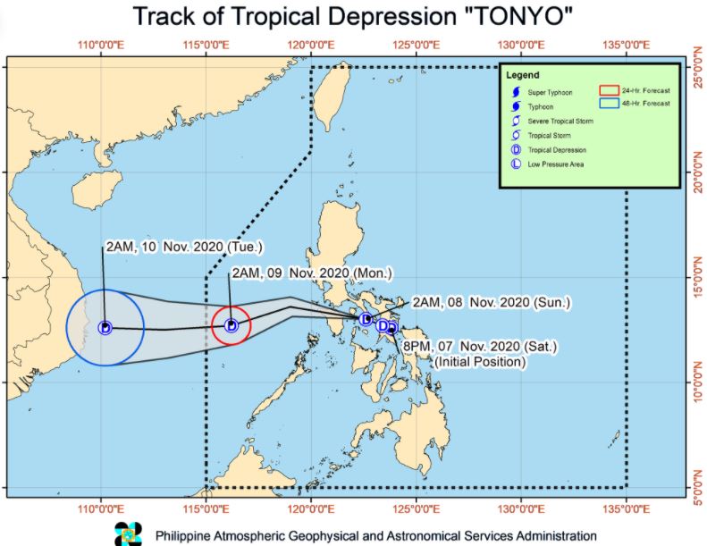
On the forecast track, 'Bagyong Tonyo' will emerge over the West Philippine Sea this morning and exit the Philippine Area of Responsibility (PAR) tomorrow morning.
At 4:00 am today, the center of Tropical Depression 'Tonyo' was estimated based on all available data at 90 km South Southeast of Alabat, Quezon.
'Bagyong Tonyo' has maximum sustained winds of 45 km/h near the center and gustiness of up to 60 km/h. It is moving West Northwestward at 25 km/h.
Forecast Positions
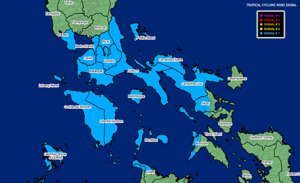
TROPICAL CYCLONE WIND SIGNAL
TCWS #1 (30-60 km/h winds prevailing or expected in 36 hours)
Luzon
Visayas
Hazards affecting land areas
Heavy rainfall: Today, 'Tonyo' will bring moderate to heavy rains over Mindoro Provinces, the northern portion of Quezon including Polillo Islands, Aurora, and the eastern portions of mainland Cagayan and Isabela.
Light to moderate with at times heavy rains will also be experienced over the Ilocos Region, Cordillera Administrative Region, Metro Manila, and the rest of Central Luzon, CALABARZON, and MIMAROPA.
Flooding (including flashfloods and rain-induced landslides may occur during heavy or prolonged rainfall especially in areas that are highly or very highly susceptible to these hazards and/or those that received significant antecedent rainfall.
Strong winds: Areas under Tropical Cyclone Wind Signal #1 is currently experiencing or will be experiencing strong breeze to near gale conditions with occasional gusts throughout the passage of 'Tonyo'.
The Northeast Monsoon will also bring strong breeze to near gale conditions over Batanes, Babuyan Islands, Ilocos Norte, Apayao, and the northern portion of mainland Cagayan.
Hazards affecting coastal waters
Moderate to rough seas (1.5 to 3.5 m) due to 'Tonyo' and the prevailing easterlies will be experienced over the seaboards of areas under TCWS #1 and the eastern seaboards of Cagayan Valley, Aurora, and the northern portion of Quezon, and the northern and eastern seaboards of Catanduanes.
Mariners of small seacrafts are advised to take precautionary measures when venturing out to sea. Inexperienced mariners should avoid navigating in these conditions.
The Northeast Monsoon will bring rough to very rough seas (2.5 to 3.5 m) over the seaboards of Batanes, Ilocos Norte, and Ilocos Sur and the northern seaboard of Cagayan including Babuyan Islands. Sea travel is risky over these waters, especially for mariners of small seacrafts.
'Bagyong Tonyo' is the Philippines' 20th tropical cyclone for 2020 and second for November.
On average, there are 20 tropical cyclones that could form or enter the PAR each year. Only half of those are projected to make landfall.
However, the weather bureau advised of more cyclones that could enter PAR until December.
PAGASA declared the onset of rainy season on June 12.
— The Summit Express
At 4:00 am today, the center of Tropical Depression 'Tonyo' was estimated based on all available data at 90 km South Southeast of Alabat, Quezon.
'Bagyong Tonyo' has maximum sustained winds of 45 km/h near the center and gustiness of up to 60 km/h. It is moving West Northwestward at 25 km/h.
Forecast Positions
- 24 Hour (Tomorrow morning): 440 km West of Coron, Palawan
- 48 Hour (Tuesday morning):1,090 km West of Southern Luzon (OUTSIDE PAR)
TROPICAL CYCLONE WIND SIGNAL
TCWS #1 (30-60 km/h winds prevailing or expected in 36 hours)
Luzon
- Camarines Norte
- Camarines Sur
- the western portion of Albay (Polangui, Oas, Ligao City, Pio Duran, Libon)
- the western portion of Masbate (Aroroy, Mandaon, Balud) including Burias Island
- Quezon including Polillo Islands
- Cavite
- Laguna
- Rizal
- Batangas
- Metro Manila
- Bataan
- Marinduque
- Romblon
- Oriental Mindoro
- Occidental Mindoro including Lubang Island
- Calamian Islands
Visayas
- the northwestern portion of Aklan (Buruanga, Ibajay, Tangalan, Makato, Numancia, Nabas, Malay)
- the northern portion of Antique (Pandan, Libertad, Caluya)
Hazards affecting land areas
Heavy rainfall: Today, 'Tonyo' will bring moderate to heavy rains over Mindoro Provinces, the northern portion of Quezon including Polillo Islands, Aurora, and the eastern portions of mainland Cagayan and Isabela.
Light to moderate with at times heavy rains will also be experienced over the Ilocos Region, Cordillera Administrative Region, Metro Manila, and the rest of Central Luzon, CALABARZON, and MIMAROPA.
Flooding (including flashfloods and rain-induced landslides may occur during heavy or prolonged rainfall especially in areas that are highly or very highly susceptible to these hazards and/or those that received significant antecedent rainfall.
Strong winds: Areas under Tropical Cyclone Wind Signal #1 is currently experiencing or will be experiencing strong breeze to near gale conditions with occasional gusts throughout the passage of 'Tonyo'.
The Northeast Monsoon will also bring strong breeze to near gale conditions over Batanes, Babuyan Islands, Ilocos Norte, Apayao, and the northern portion of mainland Cagayan.
Hazards affecting coastal waters
Moderate to rough seas (1.5 to 3.5 m) due to 'Tonyo' and the prevailing easterlies will be experienced over the seaboards of areas under TCWS #1 and the eastern seaboards of Cagayan Valley, Aurora, and the northern portion of Quezon, and the northern and eastern seaboards of Catanduanes.
Mariners of small seacrafts are advised to take precautionary measures when venturing out to sea. Inexperienced mariners should avoid navigating in these conditions.
The Northeast Monsoon will bring rough to very rough seas (2.5 to 3.5 m) over the seaboards of Batanes, Ilocos Norte, and Ilocos Sur and the northern seaboard of Cagayan including Babuyan Islands. Sea travel is risky over these waters, especially for mariners of small seacrafts.
'Bagyong Tonyo' is the Philippines' 20th tropical cyclone for 2020 and second for November.
On average, there are 20 tropical cyclones that could form or enter the PAR each year. Only half of those are projected to make landfall.
However, the weather bureau advised of more cyclones that could enter PAR until December.
PAGASA declared the onset of rainy season on June 12.
— The Summit Express


