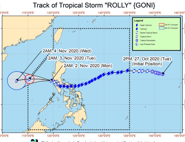
MANILA, Philippines – 'Bagyong Rolly' (Goni) continues to weaken over the West Philippine Sea and forecast to exit the Philippine Area of Responsibility (PAR) tomorrow morning, state weather bureau PAGASA announced in its 5:00 am bulletin on Monday, November 2, 2020.
'Rolly' is forecast to remain as a tropical storm throughout the forecast period. However, there is an increasing likelihood that 'Rolly' will weaken into a tropical depression due to increasingly unfavorable conditions.
 |
| Satellite image of Tropical Storm 'Rolly' (Goni) as of 5:10 am, November 2, 2020. PAGASA |
'Rolly' is forecast to remain as a tropical storm throughout the forecast period. However, there is an increasing likelihood that 'Rolly' will weaken into a tropical depression due to increasingly unfavorable conditions.
UPDATES
At 4:00 am today, the center of 'Bagyong Rolly' was estimated based on all available data at 100 km West Southwest of Subic Bay.
'Rolly' has maximum sustained winds of 65 km/h near the center and gustiness of up to 80 km/h. It is moving West Northwestward at 20 km/h.
Forecast Positions
TROPICAL CYCLONE WIND SIGNAL
TCWS No. 1 (30-60 km/h winds prevailing or expected in 36 hours)
Impacts of the wind
Hazards affecting land areas
Strong breeze to near gale conditions with occasional gusts for areas under TCWS #1, Batanes, Babuyan Islands, Ilocos Region, Cordillera Administrative Region, and the northern portions of mainland Cagayan and Zambales.
Hazards affecting coastal waters
Rough to very rough seas (2.5 to 5.0 m) will prevail over the seaboards of Northern Luzon and Central Luzon, the western seaboards of Batangas, Occidental Mindoro including Burias Island, and Calamian Islands, and eastern seaboards of Quezon including Polillo Islands and Bicol Region.
Sea travel is risky over these waters, especially for those using small seacrafts.
Moderate to rough seas (1.2 to 2.5 m) will be experienced over the western seaboards of Palawan including Kalayaan Islands and the eastern seaboards of Visayas and Mindanao.
Mariners of small seacrafts are advised to take precautionary measures when venturing out to sea. Inexperienced mariners should avoid navigating in these conditions.
SEE ALSO: 'Bagyong Siony' PAGASA weather update November 1, 2020
'Bagyong Rolly' is the Philippines' 18th tropical cyclone for 2020, and the 5th for October.
On average, there are 20 tropical cyclones that could form or enter the PAR each year. Only half of those are projected to make landfall.
PAGASA declared the onset of rainy season on June 12.
— The Summit Express
'Rolly' has maximum sustained winds of 65 km/h near the center and gustiness of up to 80 km/h. It is moving West Northwestward at 20 km/h.
Forecast Positions
- 24 Hour (Tomorrow morning): 540 km West of Subic Bay
- 48 Hour (Wednesday morning): 805 km West of Central Luzon (OUTSIDE PAR)
TROPICAL CYCLONE WIND SIGNAL
TCWS No. 1 (30-60 km/h winds prevailing or expected in 36 hours)
- the northwestern portion of Occidental Mindoro (Paluan, Mamburao, Abra de Ilog) including Lubang Island
- the western portion of Batangas (Tingloy, Mabini, Bauan, San Luis, Taal, Agoncillo, San Nicolas, Santa Teresita, Talisay, Laurel, Lemery, Calaca, Balayan, Calatagan, Tuy, Lian, Nasugbu)
- the extreme western portion of Laguna (San Pedro City, Biñan City)
- Cavite
- Metro Manila
- the western portion of Bulacan (San Jose del Monte City, Santa Maria, Pandi, Bustos, Baliuag, Marilao, Meycauayan City, Obando, Bocaue, Bulacan, Balagtas, Guiguinto, Pulilan, Plaridel, Malolos City, Paombong, Hagonoy, Calumpit) the western portion of Pampanga (San Luis, Mexico, Masantol, Sasmuan, Floridablanca, Lubao, Porac, Guagua, Santa Rita, Bacolor, Angeles City, Santo Tomas, San Fernando City, San Simon, Macabebe, Minalin, Apalit)
- Bataan
- the southern portion of Zambales (San Marcelino, San Felipe, San Narciso, San Antonio, Castillejos, Subic, Olongapo City)
Impacts of the wind
- Very light or no damage to low risk structures
- Light damage to medium to high risk structures
- Slight damage to some houses of very light materials or makeshift structures in exposed communities. Some banana plants are tilted, a few downed and leaves are generally damaged
- Twigs of small trees may be broken.
- Rice crops, however, may suffer significant damage when it is in its flowering stage.
Hazards affecting land areas
Strong breeze to near gale conditions with occasional gusts for areas under TCWS #1, Batanes, Babuyan Islands, Ilocos Region, Cordillera Administrative Region, and the northern portions of mainland Cagayan and Zambales.
Hazards affecting coastal waters
Rough to very rough seas (2.5 to 5.0 m) will prevail over the seaboards of Northern Luzon and Central Luzon, the western seaboards of Batangas, Occidental Mindoro including Burias Island, and Calamian Islands, and eastern seaboards of Quezon including Polillo Islands and Bicol Region.
Sea travel is risky over these waters, especially for those using small seacrafts.
Moderate to rough seas (1.2 to 2.5 m) will be experienced over the western seaboards of Palawan including Kalayaan Islands and the eastern seaboards of Visayas and Mindanao.
Mariners of small seacrafts are advised to take precautionary measures when venturing out to sea. Inexperienced mariners should avoid navigating in these conditions.
SEE ALSO: 'Bagyong Siony' PAGASA weather update November 1, 2020
'Bagyong Rolly' is the Philippines' 18th tropical cyclone for 2020, and the 5th for October.
On average, there are 20 tropical cyclones that could form or enter the PAR each year. Only half of those are projected to make landfall.
PAGASA declared the onset of rainy season on June 12.
— The Summit Express


