MANILA, Philippines – Signal No. 4, the second highest tropical cyclone warning signal, was raised by state weather bureau PAGASA in two areas Saturday as 'Bagyong Rolly' (Goni), 2020's strongest storm on Earth, threatens Bicol region.
UPDATE: 'Rolly' intensifies into Super Typhoon; Signal No. 5 up in 3 areas
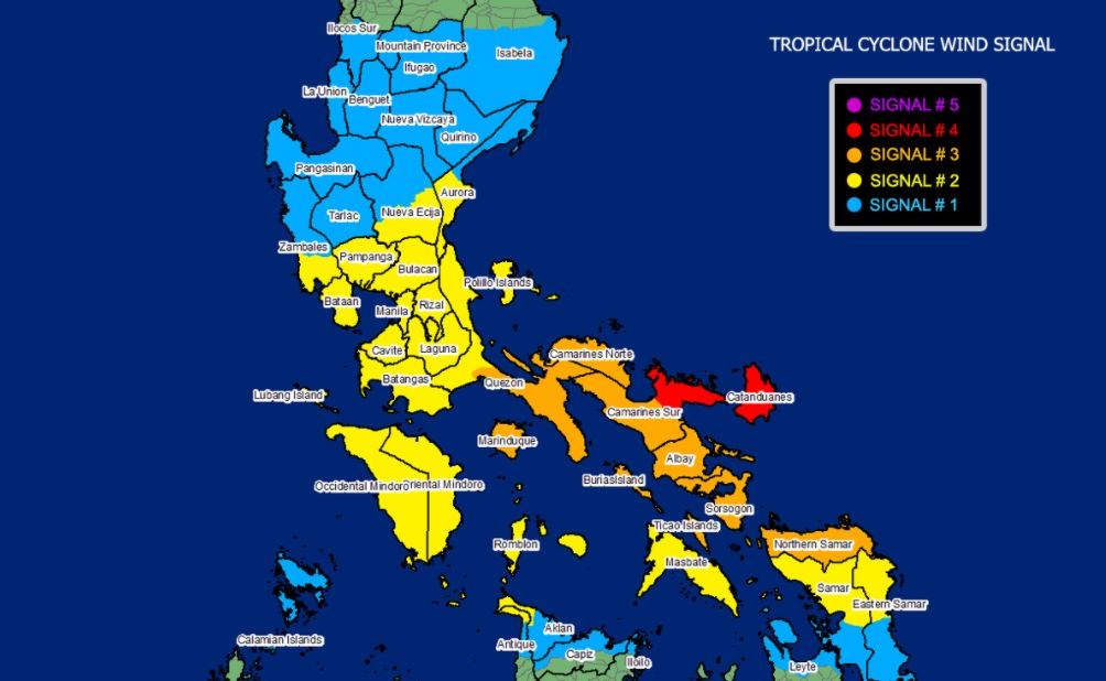
Residents of Catanduanes and the eastern portion of Camarines Sur (Siruma, Tinambac, Goa, Lagonoy, San Jose, Garchitorena, Presentacion, Caramoan) were alerted of Signal No. 4, which means winds of greater than 171 km/h up to 220 km/h may be expected in at least 12 hours.
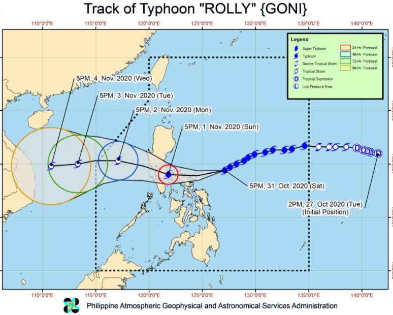
In its 8:00 pm bulletin today, October 31, PAGASA said the center of the eye of Typhoon 'Rolly' is likely to make landfall over Catanduanes tomorrow early morning, then it will pass over mainland Camarines Provinces tomorrow morning, and over mainland Quezon tomorrow afternoon.
Violent winds and intense rainfall associated with the inner rainband-eyewall region will be experienced over Catanduanes, Camarines Provinces tomorrow early morning through afternoon and over Quezon tomorrow afternoon through evening.
After crossing the Southern Luzon - Metro Manila area, the center of Typhoon 'Rolly' is forecast to exit the mainland Luzon landmass on Monday early morning.
PAGASA said 'Rolly' is likely to remain a typhoon category (185-215 km/h) by the time it makes landfall.
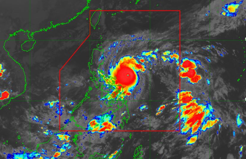
At 7:00 pm today, the eye of Typhoon 'Rolly' was located based on all available data at 280 km East Northeast of Virac, Catanduanes.
'Rolly' has maximum sustained winds of 215 km/h near the center and gustiness of up to 165 km/h. It is moving West Southwestward at 20 km/h.
Forecast Position
Tropical Cyclone Wind Signal
TCWS No. 4 (Winds of greater than 171 km/h up to 220 km/h may be expected in at least 12 hours)
TCWS No. 3 (Winds of greater than 121 km/h up to 170 km/h may be expected in at least 18 hours)
TCWS No. 2 (Winds of greater than 61 km/h and up to 120 km/h may be expected in at least 24 hours)
TCWS No. 1 (Winds of 30-60 km/h may be expected in at least 36 hours)
Hazards affecting land areas
Rainfall: Tonight, the outer rainbands of 'Rolly' will bring light to moderate with at times heavy rains over Bicol Region, Visayas, and Quezon.
Beginning tomorrow early morning, the passage of Typhoon 'Rolly' will bring heavy to intense rains over Metro Manila, Bicol Region, CALABARZON, Aurora, Bulacan, Zambales, Bataan, Marinduque, Romblon, Occidental Mindoro, and Oriental Mindoro.
Moderate to heavy rains with at times intense rains will be experienced over Cagayan Valley, Cordillera Administrative Region, Ilocos Region, and the rest of Central Luzon.
Flooding (including flash floods), rain-induced landslides, and sediment-laden streamflows (i.e. lahar) may occur during heavy or prolonged rainfall especially in areas that are highly or very highly susceptible to these hazards.
Strong winds: Very destructive typhoon-force winds will be experienced in areas under TCWS #4, destructive typhoon-force winds in areas under TCWS #3 damaging gale- to storm-force winds in areas under TCWS #2, and strong breeze to near gale conditions in areas under TCWS #1.
Elsewhere, strong breeze to near gale conditions due to the northeasterlies will be experienced over Batanes, Babuyan Islands, Ilocos Norte, Apayao, and the coastal and mountainous areas of Cagayan and Isabela (that are not under TCWS #1).
Storm surge
This storm surge may be accompanied by swells and breaking waves reaching the coast.
Hazards affecting coastal waters
Today, rough to phenomenal seas (2.5 to 15.0 m) will be experienced over the seaboard of areas where TCWS is in effect and rough to very rough seas (2.5 to 5.0 m) over the remaining seaboards of Northern Luzon and the eastern seaboards of Eastern Visayas (that are not under TCWS) and Caraga.
Sea travel is risky for all types of seacrafts over these waters, especially those under TCWS.
Moderate to rough seas (1.2 to 2.5 m) will be experienced over remaining seaboards of the country. Mariners of small seacrafts are advised to take precautionary measures when venturing out to sea. Inexperienced mariners should avoid navigating in these conditions.
Other tropical systems being monitored
At 7:00 PM today, the center of Tropical Depression 'Atsani' was estimated at 1,480 km East of Southern Luzon.
It currently has maximum sustained winds of 55 km/h near the center and gustiness of up to 70 km/h.
It is moving northwestward at 25 km/h and is forecast to enter the Philippine Area of Responsibility tomorrow afternoon.
However, it remains less likely to affect any portion of the country over the next 2 to 3 days. It is likely to re-intensify into a tropical storm in the next 24 hours.
'Bagyong Rolly' is the Philippines' 18th tropical cyclone for 2020, and the 5th for October.
On average, there are 20 tropical cyclones that could form or enter the PAR each year. Only half of those are projected to make landfall.
PAGASA declared the onset of rainy season on June 12.
— The Summit Express
 |
| Satellite image of Typhoon Rolly as of 8:20 pm on Saturday, October 31, 2020. PAGASA |
Residents of Catanduanes and the eastern portion of Camarines Sur (Siruma, Tinambac, Goa, Lagonoy, San Jose, Garchitorena, Presentacion, Caramoan) were alerted of Signal No. 4, which means winds of greater than 171 km/h up to 220 km/h may be expected in at least 12 hours.
In its 8:00 pm bulletin today, October 31, PAGASA said the center of the eye of Typhoon 'Rolly' is likely to make landfall over Catanduanes tomorrow early morning, then it will pass over mainland Camarines Provinces tomorrow morning, and over mainland Quezon tomorrow afternoon.
Violent winds and intense rainfall associated with the inner rainband-eyewall region will be experienced over Catanduanes, Camarines Provinces tomorrow early morning through afternoon and over Quezon tomorrow afternoon through evening.
After crossing the Southern Luzon - Metro Manila area, the center of Typhoon 'Rolly' is forecast to exit the mainland Luzon landmass on Monday early morning.
PAGASA said 'Rolly' is likely to remain a typhoon category (185-215 km/h) by the time it makes landfall.
At 7:00 pm today, the eye of Typhoon 'Rolly' was located based on all available data at 280 km East Northeast of Virac, Catanduanes.
'Rolly' has maximum sustained winds of 215 km/h near the center and gustiness of up to 165 km/h. It is moving West Southwestward at 20 km/h.
Forecast Position
- 24 Hour(Tomorrow afternoon): In the vicinity of Pagbilao, Quezon
- 48 Hour(Monday afternoon): 310 km West of Iba, Zambales
- 72 Hour (Tuesday afternoon): 720 km West of Iba, Zambales (OUTSIDE PAR)
- 96 Hour(Wednesday afternoon):1,020 km West of Central Luzon (OUTSIDE PAR)
Tropical Cyclone Wind Signal
TCWS No. 4 (Winds of greater than 171 km/h up to 220 km/h may be expected in at least 12 hours)
- Catanduanes
- the eastern portion of Camarines Sur (Siruma, Tinambac, Goa, Lagonoy, San Jose, Garchitorena, Presentacion, Caramoan)
TCWS No. 3 (Winds of greater than 121 km/h up to 170 km/h may be expected in at least 18 hours)
- Camarines Norte
- the rest of Camarines Sur
- Albay
- Sorsogon
- Burias and Ticao Islands
- Marinduque
- the southern portion of Quezon (Atimonan, Pagbilao, Padre Burgos, Agdangan, Unisan, Plaridel, Gumaca, Pitogo, Macalelon, Lopez, General Luna, Catanauan, Mulanay, San Francisco, San Andres, San Narciso, Buenavista, Guinayangan, Tagkawayan, Calauag, Quezon, Alabat, Perez)
- Northern Samar
TCWS No. 2 (Winds of greater than 61 km/h and up to 120 km/h may be expected in at least 24 hours)
- Pampanga
- Bulacan
- the southern portion of Nueva Ecija (Cabiao, San Isidro, Gapan City, General Tinio, Peñaranda, San Antonio, Jaen, San Leonardo, Santa Rosa, Cabanatuan City, Palayan City, Laur, Gabaldon, Bongabon)
- the southern portion of Zambales (San Marcelino, San Felipe, San Narciso, San Antonio, Castillejos, Subic, Olongapo City)
- Bataan
- Metro Manila
- Rizal
- Cavite
- Batangas
- Laguna
- the southern portion of Aurora (Maria Aurora, San Luis, Baler, Dingalan)
- the rest of Quezon including Polillo Islands
- the rest of Masbate
- Romblon
- Oriental Mindoro
- Occidental Mindoro including Lubang Island
- the northern portion of Samar (Catbalogan City, Jiabong, Motiong, Paranas, Hinabangan, San Sebastian, Tarangnan, San Jorge, San Jose de Buan, Matuguinao, Gandara, Santa Margarita, Calbayog City, Santo Nino, Almagro, Tagapul-An)
- the northern portion of Eastern Samar (San Julian, Sulat, Taft, Can-Avid, Dolores, Maslog, Oras, San Policarpo, Arteche, Jipapad)
- the extreme northern portion of Antique (Pandan, Libertad, Caluya)
- the northwestern portion of Aklan (Buruanga, Malay, Nabas, Ibajay)
TCWS No. 1 (Winds of 30-60 km/h may be expected in at least 36 hours)
- the rest of Zambales
- Tarlac
- the rest of Nueva Ecija
- the rest of Aurora
- Pangasinan
- La Union
- the southern portion of Ilocos Sur (Quirino, Gregorio Del Pilar, Salcedo, San Emilio, Candon City, Galimuyod, Santa Lucia, Cervantes, Sigay, Santa Cruz, Suyo, Tagudin, Alilem, Sugpon)
- Mountain Province
- Benguet
- Ifugao
- Nueva Vizcaya
- Quirino
- the central and southern portions of Isabela (Mallig, Quirino, Ilagan, Roxas, San Manuel, Burgos, Gamu, Palanan, San Mariano, Benito Soliven, Naguilian, Reina Mercedes, Luna, Aurora, Cabatuan, San Mateo, Cauayan City, Dinapigue, San Guillermo, Echague, San Agustin, Jones, Angadanan, Alicia, San Isidro, Ramon, Santiago City, Cordon)
- Calamian Islands
- Biliran
- the northern portion of Antique (Sebaste, Culasi)
- the rest of Aklan
- the northern portion of Capiz (Jamindan, Mambusao, Sapi-An, Ivisan, Roxas City, Panay, Pilar, Sigma, Dao, Panitan, Pontevedra, President Roxas)
- the northern portion of Iloilo (Carles, Balasan, Estancia, Batad)
Hazards affecting land areas
Rainfall: Tonight, the outer rainbands of 'Rolly' will bring light to moderate with at times heavy rains over Bicol Region, Visayas, and Quezon.
Beginning tomorrow early morning, the passage of Typhoon 'Rolly' will bring heavy to intense rains over Metro Manila, Bicol Region, CALABARZON, Aurora, Bulacan, Zambales, Bataan, Marinduque, Romblon, Occidental Mindoro, and Oriental Mindoro.
Moderate to heavy rains with at times intense rains will be experienced over Cagayan Valley, Cordillera Administrative Region, Ilocos Region, and the rest of Central Luzon.
Flooding (including flash floods), rain-induced landslides, and sediment-laden streamflows (i.e. lahar) may occur during heavy or prolonged rainfall especially in areas that are highly or very highly susceptible to these hazards.
Strong winds: Very destructive typhoon-force winds will be experienced in areas under TCWS #4, destructive typhoon-force winds in areas under TCWS #3 damaging gale- to storm-force winds in areas under TCWS #2, and strong breeze to near gale conditions in areas under TCWS #1.
Elsewhere, strong breeze to near gale conditions due to the northeasterlies will be experienced over Batanes, Babuyan Islands, Ilocos Norte, Apayao, and the coastal and mountainous areas of Cagayan and Isabela (that are not under TCWS #1).
Storm surge
- more than 3.0 m over the northern coastal areas of Quezon including Polillo Islands, Camarines Provinces, and Catanduanes
- 2.1 to 3.0 m over the coastal areas of Manila, Cavite, Bulacan, Pampanga, Bataan, the southeastern coastal area of Batangas and the southwestern coastal area of Quezon
- 1.0 to 2.0 m over the coastal areas of Aurora, Zambales, Occidental Mindoro, the rest of the coastal areas of Bicol Region, Batangas, and Quezon
This storm surge may be accompanied by swells and breaking waves reaching the coast.
Hazards affecting coastal waters
Today, rough to phenomenal seas (2.5 to 15.0 m) will be experienced over the seaboard of areas where TCWS is in effect and rough to very rough seas (2.5 to 5.0 m) over the remaining seaboards of Northern Luzon and the eastern seaboards of Eastern Visayas (that are not under TCWS) and Caraga.
Sea travel is risky for all types of seacrafts over these waters, especially those under TCWS.
Moderate to rough seas (1.2 to 2.5 m) will be experienced over remaining seaboards of the country. Mariners of small seacrafts are advised to take precautionary measures when venturing out to sea. Inexperienced mariners should avoid navigating in these conditions.
Other tropical systems being monitored
At 7:00 PM today, the center of Tropical Depression 'Atsani' was estimated at 1,480 km East of Southern Luzon.
It currently has maximum sustained winds of 55 km/h near the center and gustiness of up to 70 km/h.
It is moving northwestward at 25 km/h and is forecast to enter the Philippine Area of Responsibility tomorrow afternoon.
However, it remains less likely to affect any portion of the country over the next 2 to 3 days. It is likely to re-intensify into a tropical storm in the next 24 hours.
'Bagyong Rolly' is the Philippines' 18th tropical cyclone for 2020, and the 5th for October.
On average, there are 20 tropical cyclones that could form or enter the PAR each year. Only half of those are projected to make landfall.
PAGASA declared the onset of rainy season on June 12.
— The Summit Express


