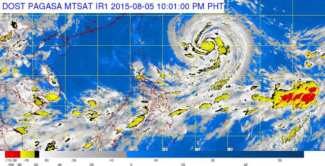
MANILA, Philippines - State weather bureau PAGASA said that Typhoon Hanna (international name: Soudelor) has weakened while continuously moving in west northwest direction as stated on its 11:00pm update Wednesday, August 5, 2015.
At 10:00 PM today, the eye of Typhoon Hanna was located based on all available data at 1,060 km East of Basco, Batanes (20.1°N, 132.1°E).
It has maximum sustained winds of 175 kph near the center and gustiness of up to 210 kph and forecast to move West Northwest at 20 kph.
Forecast Positions:
Impacts of the wind:
The estimated rainfall amount is from moderate to heavy within the 650 km diameter of the typhoon.
Fisher folk are advised not to venture out over the Northern and Eastern seaboards of Luzon, the seaboards of Palawan, of Visayas and of Mindanao.
The public and the disaster risk reduction and management council concerned are advised to take appropriate actions and watch for the next bulletin.
At 10:00 PM today, the eye of Typhoon Hanna was located based on all available data at 1,060 km East of Basco, Batanes (20.1°N, 132.1°E).
It has maximum sustained winds of 175 kph near the center and gustiness of up to 210 kph and forecast to move West Northwest at 20 kph.
Forecast Positions:
- 24 hour (Tomorrow evening, August 6): 605 km East Northeast of Itbayat, Batanes
- 48 hour (Friday evening): 260 km North Northeast of Itbayat, Batanes
- 72 hour (Saturday evening): Outside PAR or 650 km North Northwest of Itbayat, Batanes
- 96 hour (Sunday evening): at 1200 km North Northwest of Itbayat, Batanes
Impacts of the wind:
- Very light or no damage to high risk structures,
- Light damage to medium to low risk structures
- Slight damage to some houses of very light materials or makeshift structures in exposed communities. Some banana plants are tilted, a few downed and leaves are generally damaged
- Twigs of small trees may be broken.
- Rice crops, however, may suffer significant damage when it is in its flowering stage.
- Wave Height: (Open Sea) 1.25-4.0 meters
The estimated rainfall amount is from moderate to heavy within the 650 km diameter of the typhoon.
Fisher folk are advised not to venture out over the Northern and Eastern seaboards of Luzon, the seaboards of Palawan, of Visayas and of Mindanao.
The public and the disaster risk reduction and management council concerned are advised to take appropriate actions and watch for the next bulletin.


